Situation Summary
Finland maintains a composite threat score of 6 (global rank #null), reflecting a low overall security risk profile. No discrete security events have been confirmed in the last 24–48 hours. The most recent confirmed operational development—airspace and maritime restrictions near the Russian border due to drone risk—dates to 28 July 2026 and remains in effect, though no escalation or new incident has been reported since that time.
Key Developments
No confirmed discrete security events have been verified in Finland during the last 24–48 hours. The most recent confirmed operational measure was implemented on 28 July 2026 in the Gulf of Finland / Southern Finland region, where Finnish military authorities closed part of the airspace and imposed maritime traffic restrictions adjacent to the Russian border in response to persistent drone activity. This restriction remains in place pending further notice. No new incidents, border incursions, criminal events, or security alerts have been corroborated within the current reporting window.
Highest-Risk Areas
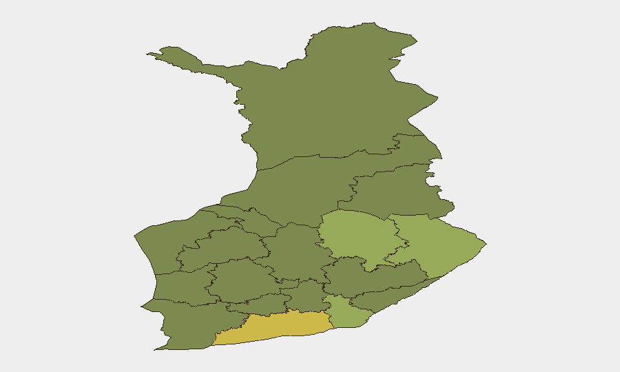
Uusimaa (risk score 65) dominates Finland's sub-national risk profile and accounts for the majority of the national composite threat score. North Karelia (44), Kymenlaakso (42), and North Savo (40) represent secondary risk concentrations, with all four regions significantly above the national mean. Uusimaa's elevation reflects its status as Finland's largest metropolitan and economic hub (Helsinki, Espoo, Vantaa); concentration of population, critical infrastructure, and economic activity naturally elevates exposure across multiple threat vectors. Eastern border regions—including North Karelia and Kymenlaakso—carry elevated risk tied to proximity to the Russian frontier and the ongoing closed-border posture (in effect since 4 June 2026). Southern regions including Uusimaa and Kymenlaakso also reflect maritime-adjacency exposure related to Gulf of Finland drone and border-security operations.
How GeoBit Would Assist
Security teams managing personnel or assets in Finland should deploy AOI (Area of Interest) Monitoring & Early Warning watches on Uusimaa, the Gulf of Finland maritime zone, and the eastern border corridor (North Karelia, Kymenlaakso) to capture any escalation in drone activity, border restrictions, or military posture changes with automated alerting. Intel Sweep, multi-language search, X/Twitter & Telegram OSINT, and sentiment analysis enable continuous near-real-time monitoring of Finnish-language security reporting, official government channels, and regional emergency services; this is particularly valuable given the current information lag in English-language sources. Routing & Network Analysis can assist duty-of-care teams in pre-positioning alternative travel routes and contingency logistics plans for high-risk regions, especially those dependent on eastern or maritime corridors.
7-Day Outlook
No near-term escalation is indicated by available intelligence. The 28 July drone-related restrictions appear to reflect tactical management rather than strategic shift and remain the dominant operational fact in the Finnish security picture. Continued monitoring of the closed eastern border and Gulf of Finland airspace is warranted; any change in restriction status, military posture, or official government guidance should be treated as a trigger for rapid escalation review.
Highest-Risk Areas — Ranked
| # | State / Region | Risk |
|---|---|---|
| 1 | Uusimaa | 65 |
| 2 | North Karelia | 44 |
| 3 | Kymenlaakso | 42 |
| 4 | North Savo | 40 |
| 5 | South Karelia | 38 |
| 6 | Kainuu | 36 |
| 7 | Päijät-Häme | 35 |
| 8 | South Savo | 32 |
| 9 | Kanta-Häme | 30 |
| 10 | Pirkanmaa | 28 |
| 11 | Central Finland | 26 |
| 12 | Southwest Finland | 25 |
Sources
Previous Daily Briefs
A new Finland brief is written every day — each with its own risk map and downloadable CSV. Here's the last week; use the calendar to go further back.
📅 Browse every day by calendar →
Highlighted days have a brief. Tap a day for that day's map & analysis, or “csv” for that day's dataset ($5).
Atlas — our AI intelligence desk — emails them this snapshot personally. Nothing else, no list.