Situation Summary
Georgia remains a stable, low-incident environment as of 14 June 2026, with no major security, conflict, civil-unrest, or infrastructure failures reported in the last 24–48 hours. Border regions adjacent to Abkhazia and South Ossetia show no new military activity or ceasefire violations, though they retain structurally elevated risk profiles. An unverified flood event is currently the primary operational concern; its precise location and damage extent require field confirmation. The national security trajectory remains routine, with standard duty-of-care vigilance sufficient for most corporate operations.
Key Developments
- Nationwide (Georgia) – 12–13 June 2026: No new major security incidents, attacks, unrest events, or infrastructure failures detected across open-source and real-time monitoring feeds.
- De facto border regions (Abkhazia- and South Ossetia-adjacent areas) – 12–13 June 2026: No new military activity, ceasefire violations, or hostile troop movements reported along lines of control during this window.
- Urban centers (Tbilisi, Batumi, Kutaisi) – 12–13 June 2026: No active protests, demonstrations, civil unrest, or targeted attacks against foreign nationals, businesses, or critical infrastructure confirmed.
- Regional transport corridors (Gori–Zugdidi axis, Batumi border crossings, Stepantsminda–Dariel Pass) – 12–13 June 2026: All major travel routes reported fully operational; no closures, checkpoint changes, or conflict-related disruptions detected.
- Weather-related disruption – ~12–13 June 2026: One flood event flagged in Georgia; location, timing, and damage extent remain unverified and require field assessment for organizations with assets in affected watersheds or transport routes.
Highest-Risk Areas
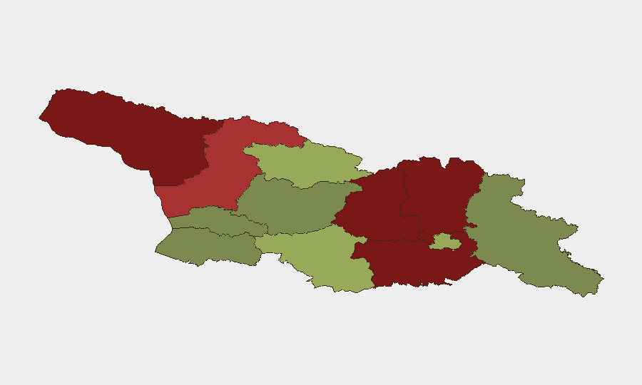
Abkhazia (risk 95), Shida Kartli (88), and Lower Kartli (85) dominate the sub-national risk profile. Abkhazia's elevation reflects the ongoing frozen conflict and de facto separation; Shida Kartli and Lower Kartli face risk from proximity to South Ossetia's line of control and historical conflict patterns. Samegrelo-Upper Svaneti (78) carries significant risk due to border proximity and infrastructure vulnerability. Tbilisi (45), despite its status as capital and primary business hub, ranks mid-tier; localized demonstrations and petty crime remain the principal concerns for international staff and assets there. Samtskhe-Javakheti (48) and southern border zones require attention for cross-border crime and smuggling activity, though not currently acute.
How GeoBit Would Assist
AOI Monitoring & Early Warning paired with OSINT fusion (multi-language feeds, X/Telegram monitoring, news aggregation) would provide continuous alerting on border-region military activity, civil unrest, and infrastructure disruption. Routing & Network Analysis enables security teams to identify alternative travel corridors and supply-chain routes in real time if primary transport axes close. Satellite & Imagery analysis and GIS & Spatial Analysis support damage assessment of the unverified flood event and ongoing monitoring of disputed-territory infrastructure.
7-Day Outlook
No significant escalation is anticipated over the next 7 days based on current trajectories. The flood event will likely dominate operational planning; its effects on transport and power grids should be clarified within 24–48 hours. Routine vigilance in Tbilisi and compliance with standard border-crossing procedures remain the baseline posture for corporate operations.
Highest-Risk Areas — Ranked
| # | State / Region | Risk |
|---|---|---|
| 1 | Autonomous Republic of Abkhazia | 95 |
| 2 | Shida Kartli | 88 |
| 3 | Lower Kartli | 85 |
| 4 | Mtskheta-Mtianeti | 82 |
| 5 | Samegrelo-Upper Svaneti | 78 |
| 6 | Samtskhe-Javakheti | 48 |
| 7 | Tbilisi | 45 |
| 8 | Racha-Lechkhumi and Kvemo Svaneti | 42 |
| 9 | Kakheti | 38 |
| 10 | Autonomous Republic of Adjara | 35 |
| 11 | Imereti | 32 |
| 12 | Guria | 28 |
Sources
Previous Daily Briefs
A new Georgia brief is written every day — each with its own risk map and downloadable CSV. Here's the last week; use the calendar to go further back.
📅 Browse every day by calendar →
Highlighted days have a brief. Tap a day for that day's map & analysis, or “csv” for that day's dataset ($5).