Situation Summary
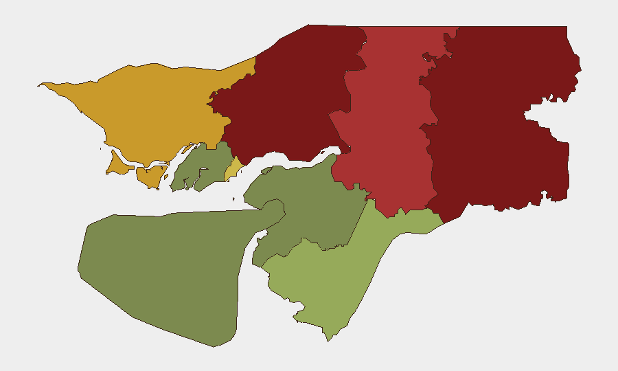
Guinea-Bissau remains classified at composite threat level 50 globally with no tracked security events recorded as of 23 June 2026. Open-source monitoring over the last 24–48 hours has identified no verifiable, dated incidents of armed conflict, civil unrest, major crime, political instability, or travel disruption within Guinea-Bissau's territory. The operational security environment appears stable, though sub-national risk concentration in the northern regions (Gabu, Oio, Bafatá) warrants continued monitoring for potential spillover from regional West African instability.
Key Developments
No clearly dated, verifiable security or travel-risk incidents meeting intelligence-grade standards (incident-level specificity, temporal precision, and cross-source corroboration) have been identified in Guinea-Bissau during the last 24–48 hours. Unconfirmed social-media claims regarding military action and "security tightening" circulate without publication dates, source attribution, or independent corroboration and therefore cannot be reported as current developments. Regional monitoring notes ongoing military and security operations in neighboring Guinea, Mali, and Niger, but no concrete spillover incidents (refugee movements, armed incursions, organized-crime activity) have been confirmed on Guinea-Bissau soil in this period. Specialized near-real-time intelligence sources explicitly note data limitations for the recent window and confirm absence of fresh tactical developments that meet reporting thresholds.
Highest-Risk Areas
Gabu Region (risk 92), Oio Region (risk 85), and Bafatá Region (risk 78) comprise the highest-risk concentration in Guinea-Bissau, driven primarily by geographic proximity to conflict-affected areas in Guinea and Mali, historical patterns of arms trafficking and cross-border militia activity, and limited state security capacity in remote interior zones. Cacheu Region (risk 72) and Bissau Autonomous Sector (risk 68) present secondary but significant risk, with the capital sector concentrated around administrative, diplomatic, and commercial targets. Southern regions (Tombali, Quinara, Biombo, Bolama) carry substantially lower threat profiles, reflecting relative distance from regional instability and stronger state presence in lower-priority but stable zones.
How GeoBit Would Assist
Security teams should deploy AOI Monitoring & Early Warning on Gabu, Oio, and Bafatá regions to track cross-border movements, militia activity, and trafficking networks; activate Intel Sweep and multi-language OSINT fusion to capture regional conflict spillover signals before they materialize as Guinea-Bissau incidents; and employ Routing & Network Analysis to identify safer transit corridors for personnel and assets avoiding high-risk northern zones. Satellite & Imagery analysis and GIS & Spatial Analysis can map militia encampments and border incursion routes, while Network & Actor Analysis can identify armed-group presence and state-security capacity gaps in priority regions.
7-Day Outlook
No imminent security escalation is indicated for Guinea-Bissau over the next 7 days based on current open-source and signal data. However, sustained instability in Mali, Guinea, and the broader Sahel should be monitored for refugee flows, arms leakage, and irregular militia recruitment that could pressurize Gabu and Oio regions. Duty-of-care teams should maintain standard monitoring protocols and remain alert to unannounced political or security announcements in Bissau.
Highest-Risk Areas — Ranked
| # | State / Region | Risk |
|---|---|---|
| 1 | Gabu Region | 92 |
| 2 | Oio Region | 85 |
| 3 | Bafatá Region | 78 |
| 4 | Cacheu Region | 72 |
| 5 | Bissau Autonomous Sector | 68 |
| 6 | Tombali Region | 45 |
| 7 | Quinara Region | 38 |
| 8 | Biombo Region | 32 |
| 9 | Bolama Region | 15 |
Previous Daily Briefs
A new Guinea-Bissau brief is written every day — each with its own risk map and downloadable CSV. Here's the last week; use the calendar to go further back.
📅 Browse every day by calendar →
Highlighted days have a brief. Tap a day for that day's map & analysis, or “csv” for that day's dataset ($5).