Situation Summary
Guyana remains in a stable security baseline with no confirmed incidents in the last 24–48 hours. The national composite threat score of 13 reflects a low overall risk environment, though significant geographic variance exists—coastal urban centers and interior mining/border zones carry elevated exposure. Corporate and field personnel should maintain routine situational awareness protocols, particularly in Demerara-Mahaica and mining regions, where localized crime and informal-economy volatility persist.
Key Developments
- No discrete security or civil-unrest events confirmed in Guyana during 19–20 June 2026. Available media coverage from Georgetown focused on diplomatic and UN-candidacy narratives; no transport, border, or violent-crime incidents were reported.
- Intelligence sweep and web-OSINT monitoring over the last 24–48 hours yielded no corroborated travel-risk alerts, protest activity, or infrastructure disruption affecting corporate operations or supply chains.
- Routine crime patterns and informal-sector activity in Georgetown and coastal zones remain consistent with baseline conditions. No spike or novel threat vector is indicated in current reporting.
Highest-Risk Areas
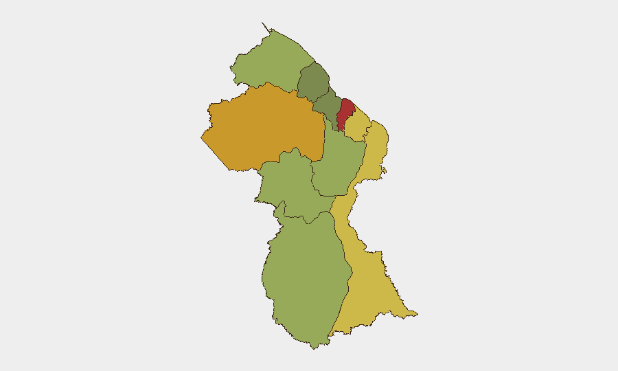
Demerara-Mahaica (risk 78) and Cuyuni-Mazaruni (risk 72) drive the sub-national risk profile. Demerara-Mahaica encompasses Georgetown and the populated coastal strip, where street crime, armed robbery, and gang activity concentrate; Cuyuni-Mazaruni, in the interior, reflects exposure to informal mining, border instability, and limited law-enforcement reach. Mahaica-Berbice and East Berbice-Corentyne follow closely, indicating that coastal and near-interior zones—particularly those linked to extraction and transshipment—carry persistent but manageable risk. Upper interior regions (Potaro-Siparuni, Upper Takutu-Upper Essequibo) and maritime zones (Essequibo Islands) show lower composite scores, though remoteness and jurisdictional complexity warrant site-specific assessment for operations in those areas.
How GeoBit Would Assist
Corporate security teams operating in Guyana should deploy AOI Monitoring & Early Warning on Georgetown, key mining corridors, and border zones to detect emerging unrest, supply-chain disruption, or criminal activity in near-real time. Multi-language web and social-media OSINT (including X/Twitter, local news, and Telegram channels) combined with sentiment and temporal analysis will flag localized crime spikes, gang activity, or protest formations before they escalate. GIS and spatial analysis, coupled with alternative routing and network planning, allows security teams to map safe transit corridors and identify high-risk checkpoints or informal roadblocks, particularly in mining regions and along interior routes.
7-Day Outlook
No material change in the baseline threat posture is anticipated over the next seven days. Guyana's political environment remains stable, and no significant economic, weather, or security trigger is evident. Standard duty-of-care vigilance—staff briefings, transport vetting, and incident-reporting discipline—remains the appropriate operational posture for all corporate personnel in-country.
Next update: 2026-06-21 | For urgent threat updates or AOI alerts, contact GeoBit Operations.
Highest-Risk Areas — Ranked
| # | State / Region | Risk |
|---|---|---|
| 1 | Demerara-Mahaica | 78 |
| 2 | Cuyuni-Mazaruni | 72 |
| 3 | Mahaica-Berbice | 65 |
| 4 | East Berbice-Corentyne | 62 |
| 5 | Upper Demerara-Berbice | 58 |
| 6 | Potaro-Siparuni | 48 |
| 7 | Barima-Waini | 45 |
| 8 | Upper Takutu-Upper Essequibo | 42 |
| 9 | Pomeroon-Supenaam | 38 |
| 10 | Essequibo Islands | 35 |
Sources
Previous Daily Briefs
A new Guyana brief is written every day — each with its own risk map and downloadable CSV. Here's the last week; use the calendar to go further back.
📅 Browse every day by calendar →
Highlighted days have a brief. Tap a day for that day's map & analysis, or “csv” for that day's dataset ($5).