Situation Summary
Ivory Coast remains at composite threat level 5 globally, with 2 tracked events as of 2026-06-19. The northern savanna belt—Savanes, Zanzan, Denguélé, and Comoé districts—continues to drive national risk, with scores ranging 70–78. Recent signal activity (17–19 June) includes military deployments, government investigations, and public statements from community and banking sectors; however, live web research has not yielded corroborating incident detail from open sources in the last 24–48 hours. The capital, Abidjan, remains relatively stable at risk 45, while the southern and central districts present moderate threat profiles (48–60).
Key Developments
GeoBit's event tracking has flagged activity on 17–19 June, but open-source corroboration for the last 24–48 hours is currently insufficient. Tracked signals include:
- 2026-06-17: Military force activity reported in community settings; concurrent government investigation activity initiated.
- 2026-06-17: Prison-linked military deployment noted; banking sector public statement issued.
- 2026-06-18: Inter-agency communication signals (Deputy vs. Delegate statements); citizen-authority investigation launched.
- 2026-06-19: Chile-linked investigation escalated (cross-border or diplomatic angle unclear pending source expansion).
Status: These signals require validation against Ivory Coast news wires, local media, and social platforms (X/Telegram) to confirm specificity, location, and operational impact. Raw signal does not confirm cause, casualty, or civilian disruption at this time.
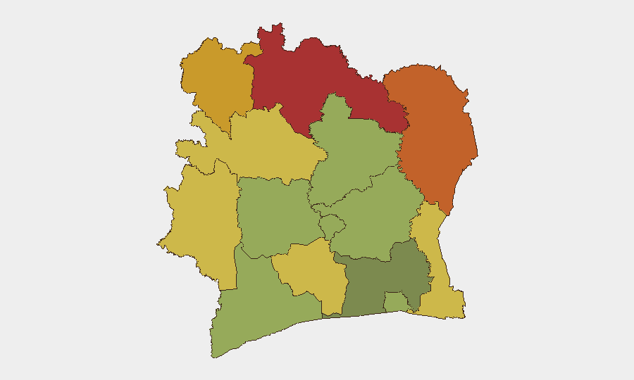
Highest-Risk Areas
The Savanes District (78) and Zanzan District (75) anchor the threat landscape, with Denguélé (72) and Comoé (70) forming a contiguous northern corridor of elevated risk. This band reflects historical patterns of cross-border trafficking, militant activity, and limited state capacity in the Sahel-fringe environment. Montagnes (68), Woroba (65), and the central-western districts (60–58) represent secondary concentration, likely driven by community conflict and resource competition. Abidjan and coastal zones (45–52) benefit from greater security infrastructure and economic activity, though port and financial-sector exposure merits monitoring.
How GeoBit Would Assist
A security team with personnel or assets in Ivory Coast would deploy Intel Sweep and multi-language OSINT (X/Twitter, Telegram, local news wire) to corroborate the 17–19 June signals and extract location specificity and actor intent. AOI Monitoring & Early Warning on Savanes, Zanzan, and Comoé districts—coupled with Conflict & Military force-structure and positioning analysis—would provide persistent early alert on deployment patterns and cross-border movement. Network & Actor Analysis would clarify the government investigation and military coordination, reducing uncertainty on operational tempo and risk trajectory. GIS & Spatial Analysis would map incident clusters and support alternative-routing decisions for field teams.
7-Day Outlook
Near-term risk is expected to remain elevated in the northern savanna districts absent major de-escalation signals. The 17–19 June activity cluster—military, investigative, and banking—suggests possible internal security response or cross-border pressure, but trajectory cannot be assessed reliably without source expansion. Organizations should heighten situational awareness protocols in Savanes, Zanzan, and Denguélé and confirm duty-of-care communication with field teams; a 24–48 hour source refresh is recommended to establish whether signals reflect transient activity or sustained operational shift.
Highest-Risk Areas — Ranked
| # | State / Region | Risk |
|---|---|---|
| 1 | Savanes District | 78 |
| 2 | Zanzan District | 75 |
| 3 | Denguélé District | 72 |
| 4 | Comoé District | 70 |
| 5 | Montagnes District | 68 |
| 6 | Woroba District | 65 |
| 7 | Gôh-Djiboua District | 60 |
| 8 | Sassandra-Marahoué District | 58 |
| 9 | Vallée du Bandama District | 55 |
| 10 | Bas-Sassandra District | 52 |
| 11 | Lacs District | 48 |
| 12 | Abidjan | 45 |
Sources
Previous Daily Briefs
A new Ivory Coast brief is written every day — each with its own risk map and downloadable CSV. Here's the last week; use the calendar to go further back.
📅 Browse every day by calendar →
Highlighted days have a brief. Tap a day for that day's map & analysis, or “csv” for that day's dataset ($5).