Situation Summary
Lebanon remains at elevated threat level (#13 globally, 88.3 composite score) with military strikes emerging as the primary driver of risk across 226 tracked events. A U.S.-brokered Israel-Lebanon ceasefire was announced during recent Washington talks, though implementation details remain under negotiation and Israeli strike activity in southern Lebanon has continued through implementation discussions. The security environment is characterized by cross-border military tension, internal political fragmentation, and competing actors operating with overlapping territorial claims.
Key Developments
- 2026-06-11 · Conventional Military Force (MILITARY vs LEBANON) — Active military operations reported; specific location and target classification under clarification. Reflects broader pattern of state-level force deployment.
- 2026-06-11 · Conventional Military Force (LEBANON) — Lebanese military or proxy force movement/activity recorded; scope and location consistent with force posture adjustments during ceasefire negotiation phase.
- 2026-06-11 · Threat (LEBANON vs ISLAMIC) — Lebanese state or officials issued threat statement toward Islamic actor (likely Iran-linked entity); timing suggests escalation response to 2026-06-08 Iranian military signals.
- 2026-06-11 · Rejection (LEBANESE vs LEBANON) — Internal political rejection or opposition to Lebanese government position or policy; indicates domestic consensus fracturing on ceasefire or military posture terms.
- 2026-06-10 · High Court Demand (HIGH COURT vs LEBANON) — Lebanese judicial authority issued binding demand on government; likely related to military operations transparency, detainee release, or ceasefire implementation oversight.
- 2026-06-09 · Artillery/Tanks (LEBANON vs ISRAEL) — Cross-border direct fire or armor engagement reported by Lebanese forces toward Israeli positions; suggests active rather than observational posture despite ceasefire talks.
- 2026-06-08 · Artillery/Tanks (IRAN vs LEBANON) — Iranian military or proxy force artillery activity within or directed at Lebanese territory; indicates IRGC/Hezbollah operational presence and potential pressure on Lebanese government during ceasefire negotiations.
Highest-Risk Areas
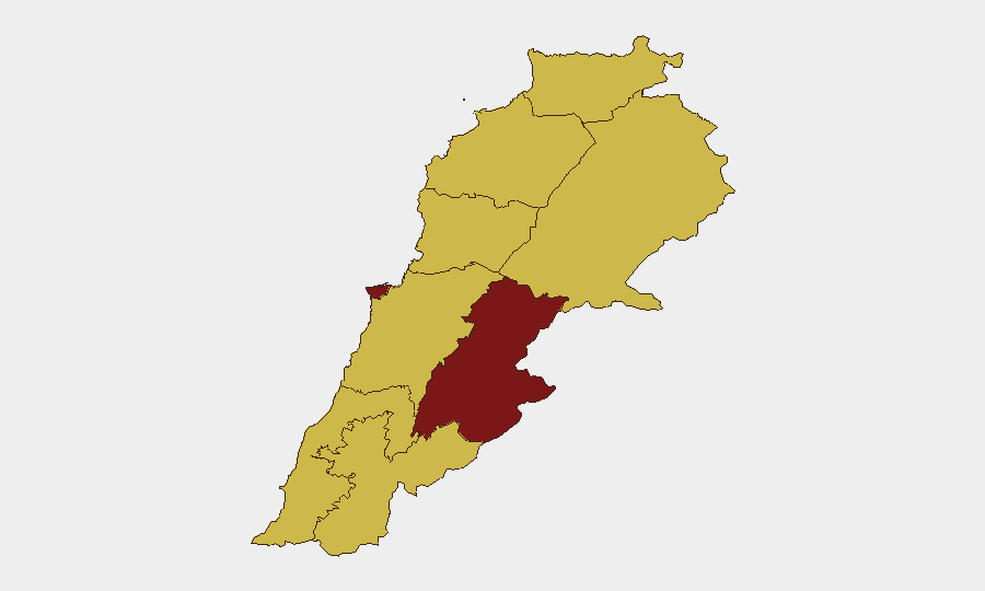
The Beqaa Governorate (91.8 risk score) dominates threat profile, reflecting its role as primary corridor for Iran-Syria-Hezbollah military logistics and command infrastructure; it remains highest-exposure zone for military strikes and cross-border activity. Beirut Governorate (82.5) carries compounded risk from government seat concentration, critical infrastructure density, and civil-military leadership fragmentation visible in the 2026-06-10 and 2026-06-11 court/rejection signals. Nabatieh and South Governorates (64.2, 63.5) reflect active Israel-Lebanon border engagement zone where ceasefire implementation will be most fragile and military incident probability highest. Secondary risk in North, Mount Lebanon, Keserwan-Jbeil, and Akkar Governorates (61.8–62.9) reflects weapons storage, supply-route vulnerability, and Sunni-aligned political actor concentration.
How GeoBit Would Assist
Teams protecting people and assets in Lebanon should use AOI Monitoring & Early Warning on Beqaa Governorate and south-Lebanon military positions to detect force repositioning and strike preparation hours before impact; Conflict & Military tracking (force structure, weapons-capability assessment) to model ceasefire compliance and defection risk; and multi-language OSINT (X/Telegram, radio SIGINT) to capture real-time Hezbollah, Iranian military, and Lebanese government communications signaling intent shifts. Routing & Network Analysis enables alternative journey planning for personnel in high-risk governorates to avoid active fire zones during implementation volatility.
7-Day Outlook
Ceasefire formalization remains pending; implementation risk is acute over next 7 days as military actors on both sides test commitment and internal Lebanese political actors contest terms. Expect continued low-intensity artillery probing, demand cycles from Lebanese courts, and potential renewed escalation if either Israel or Iran-linked forces perceive ceasefire erosion by the other party.
Highest-Risk Areas — Ranked
| # | State / Region | Risk |
|---|---|---|
| 1 | Beqaa Governorate | 91.8 |
| 2 | Beirut Governorate | 82.5 |
| 3 | Nabatieh Governorate | 64.2 |
| 4 | South Governorate | 63.5 |
| 5 | North Governorate | 62.9 |
| 6 | Akkar Governorate | 61.8 |
| 7 | Keserwan-Jbeil Governorate | 61.8 |
| 8 | Mount Lebanon Governorate | 61.8 |
| 9 | Baalbek-Hermel Governorate | 61.8 |
Sources
Previous Daily Briefs
A new Lebanon brief is written every day — each with its own risk map and downloadable CSV. Here's the last week; use the calendar to go further back.
📅 Browse every day by calendar →
Highlighted days have a brief. Tap a day for that day's map & analysis, or “csv” for that day's dataset ($5).