Situation Summary
Lesotho presents a contained but localized security environment on 2026-08-01, with no acute incidents detected in the last 24–48 hours. The country's composite threat score of 4 reflects endemic urban crime and governance fragility concentrated in the capital and surrounding districts, rather than active conflict or widespread instability. Risk is heavily weighted toward Maseru District (78) and secondary urban centers, while remote southern and eastern districts remain lower-threat. The trajectory is stable absent new political or criminal catalysts.
Key Developments
No verified security, civil-unrest, crime, political-instability, or travel-risk incidents were detected in Lesotho during the last 24–48 hours (2026-07-30 to 2026-08-01).
Recent government and civil-society announcements on cybersecurity policy and a major infrastructure investment (late July) are administrative in nature and do not constitute acute security developments.
Ongoing monitoring note: A single GEOBIT event signal ("2026-07-30 · Disapprove · AFRICA vs LESOTHO") lacks sufficient detail and corroboration to assess operational significance at this time. Further clarification from regional sources is warranted.
Highest-Risk Areas
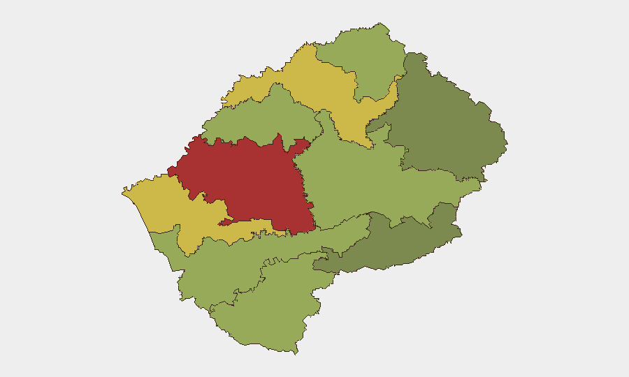
Maseru District dominates the risk profile (78), driven by urban crime, informal-settlement vulnerability, and concentration of government and commercial assets. Mafeteng (65), Leribe (62), and Berea (58) districts form a secondary tier of concern, reflecting petty crime, road-safety hazards, and limited state presence in peripheral areas. Southern and eastern districts (Qacha's Nek, Mokhotlong) show markedly lower composite scores (28–38), indicating reduced incident density and operational activity. Corporate teams with personnel in Maseru should maintain heightened situational awareness; those transiting or based in remote districts face lower acute risk but sustained logistics and medical-evacuation constraints.
How GeoBit Would Assist
Security teams should employ AOI Monitoring & Early Warning on Maseru District and key transport corridors to detect emerging crime clusters or civil disorder in real time. Intel Sweep and multi-language OSINT (local media, police announcements, X/Telegram) will provide faster detection of police operations, gang violence, or unrest than manual monitoring alone. Routing & Network Analysis can identify secure alternative routes for personnel movements, especially during periods of heightened street crime or roadway incidents. Periodic Risk & Threat Assessment updates will flag shifts in the threat landscape as political or economic conditions evolve.
7-Day Outlook
No significant changes to Lesotho's security posture are anticipated over the next seven days absent new political or criminal triggers. Routine urban crime in Maseru and secondary cities will remain the primary exposure for corporate personnel. Monitoring of government statements and regional developments (South African labor unrest, Eswatini political dynamics) should continue, as cross-border criminal activity and political spillover remain latent risks.
Highest-Risk Areas — Ranked
| # | State / Region | Risk |
|---|---|---|
| 1 | Maseru District | 78 |
| 2 | Mafeteng District | 65 |
| 3 | Leribe District | 62 |
| 4 | Berea District | 58 |
| 5 | Mohale's Hoek District | 52 |
| 6 | Butha-Buthe District | 48 |
| 7 | Thaba-Tseka District | 45 |
| 8 | Quthing District | 42 |
| 9 | Mokhotlong District | 38 |
| 10 | Qacha's Nek District | 28 |
Sources
Previous Daily Briefs
A new Lesotho brief is written every day — each with its own risk map and downloadable CSV. Here's the last week; use the calendar to go further back.
📅 Browse every day by calendar →
Highlighted days have a brief. Tap a day for that day's map & analysis, or “csv” for that day's dataset ($5).
Atlas — our AI intelligence desk — emails them this snapshot personally. Nothing else, no list.