Situation Summary
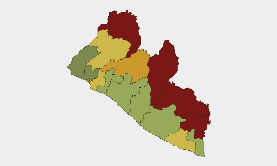
Liberia remains a low-threat environment in absolute terms (composite score 6/100) with no verified security incidents, civil unrest, armed clashes, or violent crime reported in the last 24–48 hours. The country's risk profile is heavily concentrated in remote northern and southeastern counties—Nimba, Lofa, and Grand Gedeh—where border porosity, weak state presence, and transnational criminal activity create persistent vulnerabilities. The capital and primary business hub, Monrovia, remains stable, though recent policy attention to anti-corruption and anti-smuggling operations signals government focus on institutional capacity and border security.
Key Developments
No discrete, location-specific security incidents have been corroborated in Liberia within the last 24–48 hours. Open-source monitoring across news feeds, social media, and government sources confirms absence of new protests, armed clashes, violent crime, or infrastructure emergencies in that window.
Historical context (outside 24–48h window, cited for background): Major cocaine seizures and related security-force investigations occurred July 21–24; cabinet-level anti-corruption announcements and border-enforcement policy statements emerged in late July; no incidents of this scale have recurred in the most recent 24–48-hour period.
Highest-Risk Areas
Northern and southeastern border regions drive Liberia's threat concentration. Nimba County (risk 92) and Lofa County (risk 88)—both contiguous with Guinea and Sierra Leone—face endemic challenges: porous borders, limited state policing capacity, and vulnerability to transnational drug trafficking and small-arms smuggling. Grand Gedeh County (85) and River Gee County (83) on the eastern frontier present similar vulnerabilities. Bong County (72), inland but also border-proximate, rounds the high-risk tier. By contrast, Montserrado County (64), which includes the capital Monrovia, and coastal counties rank substantially lower, reflecting stronger state presence and economic activity. Corporate operations in Monrovia and other urban centers face manageable baseline risk; field activities in Nimba, Lofa, or Grand Gedeh require heightened due diligence and local security liaison.
How GeoBit Would Assist
AOI (Area-of-Interest) Monitoring & Early Warning would provide persistent surveillance of Nimba, Lofa, and other high-risk counties, with automated alerts on emerging civil unrest, cross-border movement, or security incidents—critical for duty-of-care teams with personnel or assets in remote regions. OSINT Fusion & Corroboration across news, social media, government announcements, and radio signals would identify reliable signals of political instability, trafficking activity, or crime trends before they escalate. Routing & Network Analysis would enable security teams to plan compliant travel corridors in high-risk areas, accounting for real-time checkpoints, border crossings, and local conflict nodes. Conflict & Military monitoring—including force-structure and weapons-capability tracking—would track any changes in government or non-state armed capacity affecting overall stability.
7-Day Outlook
No imminent escalation is anticipated in the 7-day horizon. Liberia's institutional focus on anti-corruption and border security is likely to continue without major disruption to commercial or diplomatic activity. Northern and southeastern border counties will remain zones of elevated baseline risk requiring standard precautions; no acute trigger is currently visible to drive rapid deterioration in the capital or major business centers.
Highest-Risk Areas — Ranked
| # | State / Region | Risk |
|---|---|---|
| 1 | Nimba County | 92 |
| 2 | Lofa County | 88 |
| 3 | Grand Gedeh County | 85 |
| 4 | River Gee County | 83 |
| 5 | Bong County | 72 |
| 6 | Gbarpolu County | 68 |
| 7 | Grand Kru County | 65 |
| 8 | Montserrado County | 64 |
| 9 | Rivercess County | 58 |
| 10 | Sinoe County | 55 |
| 11 | Margibi County | 52 |
| 12 | Grand Bassa County | 48 |
Sources
Previous Daily Briefs
A new Liberia brief is written every day — each with its own risk map and downloadable CSV. Here's the last week; use the calendar to go further back.
📅 Browse every day by calendar →
Highlighted days have a brief. Tap a day for that day's map & analysis, or “csv” for that day's dataset ($5).
Atlas — our AI intelligence desk — emails them this snapshot personally. Nothing else, no list.