Situation Summary
Saint Lucia remains a stable jurisdiction with a composite threat score of 4 and no tracked security incidents in the current assessment window (June 15–17, 2026). Open-source reporting and social-media monitoring confirm absence of verified crime spikes, civil unrest, infrastructure disruption, or acute travel risks in the last 24–48 hours. Baseline organized-crime risks persist, concentrated in urban centers, but no new incident-level developments have emerged to alter the country's overall security posture.
Key Developments
- No new security incidents reported (June 15–17, national). Regional incident-tracking feeds explicitly note stable conditions with no new crimes, protests, infrastructure failures, or travel-risk events in the last 48 hours.
- Diplomatic communication flagged (June 15, regional context). A public statement involving Costa Rica and Saint Lucia was noted in open-source feeds; assessment indicates administrative/diplomatic character rather than security incident, with no associated unrest or disruption.
- Infrastructure and water-security messaging (mid-June, Castries/national level). Government communications emphasize funding efforts for water resilience and CARICOM engagement; no reports of protest, sabotage, or security-related disruption tied to these initiatives.
- CARICOM chairmanship preparation (mid-June, regional). Official statements confirm Saint Lucia's upcoming assumption of CARICOM leadership role; communications focus on regional economic and security challenges with no indication of domestic emergency measures or instability.
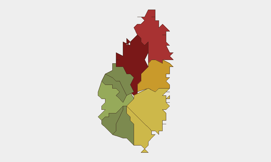
Highest-Risk Areas
Castries (risk 95) and Gros Islet (risk 78) account for the majority of sub-national threat concentration, driven by organized-crime activity, gang presence, and street-level violence typical of urban commercial and residential hubs. Dennery (72), Vieux Fort (68), and Micoud (65) represent secondary risk clusters, reflecting ongoing gang-related and property-crime patterns in semi-urban and rural settlement areas. Rural western and southern districts (Choiseul, Laborie, Canaries) carry substantially lower risk profiles. Staffing concentrations and critical assets located in Castries should remain the primary focus of duty-of-care planning.
How GeoBit Would Assist
Intel Sweep and global event feeds supply continuous baseline monitoring to detect any sudden departure from current stability; X/Twitter and Telegram OSINT provide real-time social-media sentiment and early signals of emerging unrest or crime clusters. AOI Monitoring & Early Warning on high-risk districts (Castries, Gros Islet, Dennery) enables persistent watch with alerting thresholds for incident escalation. Network & Actor Analysis maps organized-crime and gang structures to support asset-protection routing and personnel-safety protocols.
7-Day Outlook
No foreseeable acute security events are indicated for the next seven days. Water-infrastructure and CARICOM-related political activity will likely continue without incident-level disruption. Baseline crime risks in urban centers remain consistent with historical patterns; standard corporate security and duty-of-care protocols are sufficient to mitigate exposure for personnel and assets in Saint Lucia.
Highest-Risk Areas — Ranked
| # | State / Region | Risk |
|---|---|---|
| 1 | Castries | 95 |
| 2 | Gros Islet | 78 |
| 3 | Dennery | 72 |
| 4 | Vieux Fort | 68 |
| 5 | Micoud | 65 |
| 6 | Soufrière | 42 |
| 7 | Laborie | 38 |
| 8 | Choiseul | 35 |
| 9 | Anse La Raye | 28 |
| 10 | Canaries | 12 |
Sources
Previous Daily Briefs
A new Saint Lucia brief is written every day — each with its own risk map and downloadable CSV. Here's the last week; use the calendar to go further back.
📅 Browse every day by calendar →
Highlighted days have a brief. Tap a day for that day's map & analysis, or “csv” for that day's dataset ($5).