Situation Summary
Saint Vincent and the Grenadines remains a low-threat jurisdiction globally (rank #166, composite score 5), but concentrated urban crime—particularly in the capital region—creates localized risk that warrants active monitoring. Police operations and investigations into officer conduct are ongoing, signaling internal institutional scrutiny. No verified security incidents have occurred in the past 24 hours; the most recent activity (police investigations into Middle Street incidents from August 15) falls outside the immediate reporting window.
Key Developments
- No verified incidents in the last 24–48 hours. Web research and available intelligence sources have not confirmed any new security, crime, infrastructure, or civil-unrest events in Saint Vincent and the Grenadines for August 17–18, 2026.
- Police investigation ongoing (reported August 17). The Royal SVGPF launched an inquiry into firearm incidents near a bar on Middle Street, Kingstown, with shootings occurring between Friday night and Saturday morning, August 15–16. Status and outcomes remain unconfirmed.
- Earlier incident: Homicide in Rockies (August 8). Akeem Ferdinand, released from prison on July 3, 2026, was shot and killed inside a residence in Rockies. The case remains open; no arrests have been reported.
- Police conduct investigation (reported August 13). The SVGPF initiated a criminal investigation into allegations that a serving police officer engaged in illegal sexual conduct, prompted by a viral video. Outcome and disciplinary status unknown.
Highest-Risk Areas
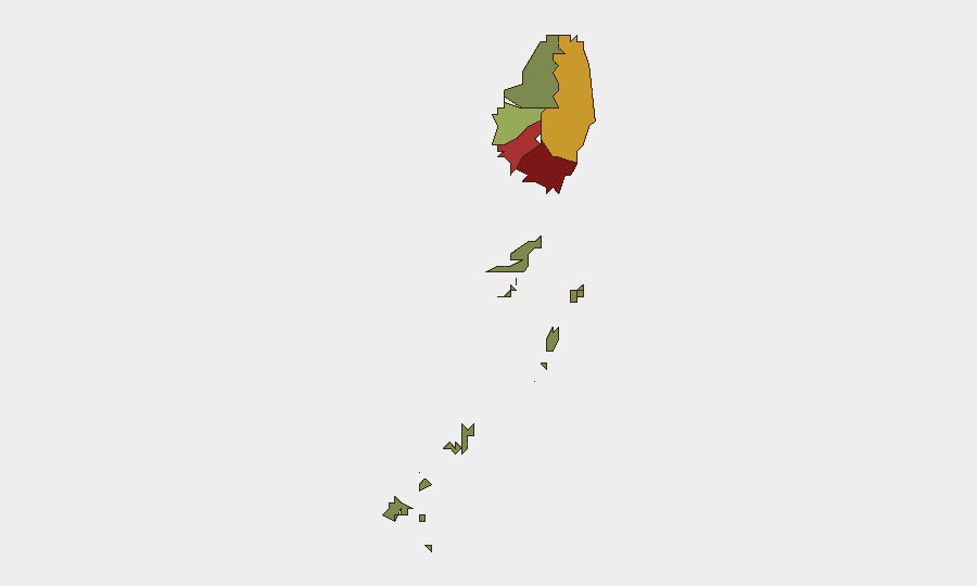
Saint George (risk 92) and Saint Andrew (risk 78) are the primary drivers of national risk, with Charlotte (71) also contributing significantly. These three parishes account for the majority of recorded violent crime and firearms incidents in the jurisdiction, concentrated in Kingstown and its immediate surroundings. The Grenadines (risk 12) present minimal threat. Risk in outer parishes (Saint Patrick, Saint David) remains moderate to low, suggesting crime and gang activity are geographically clustered in the capital and northern urban corridor. Corporate assets and personnel operating in Saint George should prioritize movement planning and incident-response protocols.
How GeoBit Would Assist
AOI Monitoring & Early Warning can establish persistent watch over Saint George and Saint Andrew parishes, triggering alerts on crime reports, police operations, and civil-unrest indicators before they escalate. Multi-language OSINT (web, X/Twitter, Telegram, YouTube) and sentiment & temporal analysis enable real-time detection of emerging threats—gang activity, protests, or police actions—in local media and social channels. Routing & Network Analysis supports duty-of-care teams in identifying alternative movement corridors within Kingstown and between key facilities, minimizing exposure to highest-risk neighborhoods. Entity extraction and network analysis can map connections between known crime actors and police investigations, supporting risk assessment for personnel and asset locations.
7-Day Outlook
No imminent security deterioration is forecast. However, outcomes of the ongoing police investigations (officer conduct, Rockies homicide, Middle Street shootings) will shape near-term institutional credibility and potential community response. Routine urban crime in Saint George and Saint Andrew should be assumed to continue at historical levels; monitoring for gang retaliation or escalation following the recent homicide is warranted.
Highest-Risk Areas — Ranked
| # | State / Region | Risk |
|---|---|---|
| 1 | Saint George | 92 |
| 2 | Saint Andrew | 78 |
| 3 | Charlotte | 71 |
| 4 | Saint Patrick | 58 |
| 5 | Saint David | 34 |
| 6 | Grenadines | 12 |
Sources
Previous Daily Briefs
A new Saint Vincent brief is written every day — each with its own risk map and downloadable CSV. Here's the last week; use the calendar to go further back.
- August 16, 2026
- August 14, 2026
- August 12, 2026
- August 10, 2026
- August 8, 2026
- August 6, 2026
- August 5, 2026
📅 Browse every day by calendar →
Highlighted days have a brief. Tap a day for that day's map & analysis, or “csv” for that day's dataset ($5).
Atlas — our AI intelligence desk — emails them this snapshot personally. Nothing else, no list.