Situation Summary
Samoa remains a low-threat environment with a composite threat score of 54 globally and no verified security incidents, civil unrest, major crime, or infrastructure disruption reported in the last 24–48 hours. However, GeoBit event signals from 17–19 June indicate scattered small-arms incidents, diplomatic friction with airlines and Papua New Guinea, and police–gang interactions, suggesting underlying tensions that warrant monitoring. Tuamasaga district (risk 85) and Ātua (risk 71) carry elevated exposure relative to the national baseline, driven by concentration of economic activity and historical incident density. The overall trajectory remains stable absent new triggering events.
Key Developments
- Tuamasaga / Nationwide (17 Jun): Multiple small-arms incidents recorded across Samoa, including police–gang interactions and armed clashes involving NSW actors; specific locations and casualty figures not confirmed in open-source reporting.
- Nationwide (17 Jun): Government disapproval statement issued regarding airline operations; details and sectoral impact remain unspecified.
- Prime Minister (17 Jun): Official disapproval statement released; context and policy implications not detailed in available reporting.
- Nationwide (18 Jun): Secondary disapproval event recorded; nature and scope unconfirmed.
- Papua New Guinea vs. Apia (19 Jun): PNG diplomatic rejection statement targeting Apia; substantive cause and escalation risk not yet clarified.
- Nationwide (18 Jun): Government public statement issued; content and intended audience not specified.
Note: No independently verified incidents of conflict, civil unrest, critical-infrastructure disruption, or travel complications were confirmed in Samoa during 15–19 June by open-source news, verified social-media accounts, or government alerts.
Highest-Risk Areas
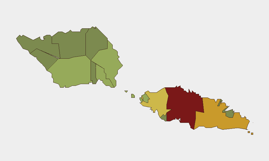
Tuamasaga (score 85) and Ātua (score 71) are the primary risk drivers, reflecting Apia's capital status, port and aviation infrastructure concentration, and historical clustering of small-arms incidents and gang activity. Aʻana (62) and Aiga-i-le-Tai (55) show moderate secondary exposure. The remaining districts exhibit significantly lower scores (23–48), indicating risk is geographically concentrated rather than nationwide. This pattern suggests that duty-of-care protocols should prioritize asset and personnel monitoring in the capital district, with standard vigilance applied elsewhere.
How GeoBit Would Assist
Security teams with personnel or assets in Samoa should employ AOI Monitoring & Early Warning on Tuamasaga and Ātua to detect re-escalation of small-arms activity or gang-related incidents in real time. Intel Sweep and OSINT fusion (X/Twitter, Telegram, multi-language local reporting) combined with sentiment and temporal analysis will clarify the diplomatic dimensions of current government statements and PNG friction, enabling risk classification. Routing & Network Analysis and Maritime & Aviation tracking will help identify safe transit corridors and departure windows if rapid movement of personnel becomes necessary.
7-Day Outlook
No imminent large-scale security deterioration is indicated by current data; however, the cluster of small-arms and diplomatic signals in mid-June suggests latent tension that could escalate if a trigger event (gang violence escalation, transport disruption, further PNG–Samoa friction) materializes. Teams should maintain standard awareness protocols and ensure communication channels with in-country contacts remain active. Reassessment warranted if incident frequency or severity increases in the coming week.
Highest-Risk Areas — Ranked
| # | State / Region | Risk |
|---|---|---|
| 1 | Tuamasaga | 85 |
| 2 | Ātua | 71 |
| 3 | Aʻana | 62 |
| 4 | Aiga-i-le-Tai | 55 |
| 5 | Faʻasaleleaga | 48 |
| 6 | Palauli | 42 |
| 7 | Satupaʻitea | 38 |
| 8 | Gagaʻemauga | 35 |
| 9 | Gagaʻifomauga | 32 |
| 10 | Vaisigano | 28 |
| 11 | Vaʻa-o-Fonoti | 23 |
Sources
Previous Daily Briefs
A new Samoa brief is written every day — each with its own risk map and downloadable CSV. Here's the last week; use the calendar to go further back.
📅 Browse every day by calendar →
Highlighted days have a brief. Tap a day for that day's map & analysis, or “csv” for that day's dataset ($5).