Situation Summary
Solomon Islands remains in a low-intensity, chronic-risk posture with no acute security incidents documented in the last 24–48 hours. The security environment is characterized by urban crime concentration, governance fragility, and diplomatic activity rather than active civil unrest, terrorism, or infrastructure disruption. No significant change in overall risk trajectory is anticipated in the immediate near term. Cross-checked open-source monitoring (national broadcaster SIBC, regional outlets, and official channels) confirms an incident-free period across all provinces and at key transport nodes.
Key Developments
- National level, 11–12 June 2026: No reports of protests, riots, curfews, states of emergency, or major political violence posted to official government, embassy, or media channels; diplomatic and travel-access discussions dominate recent statements.
- Honiara, Guadalcanal Province, 11–12 June 2026: No documented acute security incidents, civil unrest, or targeting of foreigners; risk profile remains stable and concentrated in endemic urban crime and institutional capacity constraints rather than active conflict.
- Solomon Islands (general), 11–12 June 2026: No major crime incidents targeting foreign nationals, terrorism activity, or infrastructure disruption reported across monitored news sources and intelligence feeds; transport networks (airports, seaports) operationally stable.
- Seismic activity, mid-June 2026: Magnitude 4.7 earthquake recorded 132 km NW of Malango; no damage reports or tsunamis issued; event remains within the region's known seismic baseline and does not alter broader security posture.
- Diplomatic exchanges, 11 June 2026: Public statements from Solomon Islands government regarding China represent routine diplomatic engagement; no crisis indicators or escalatory rhetoric detected in official communications.
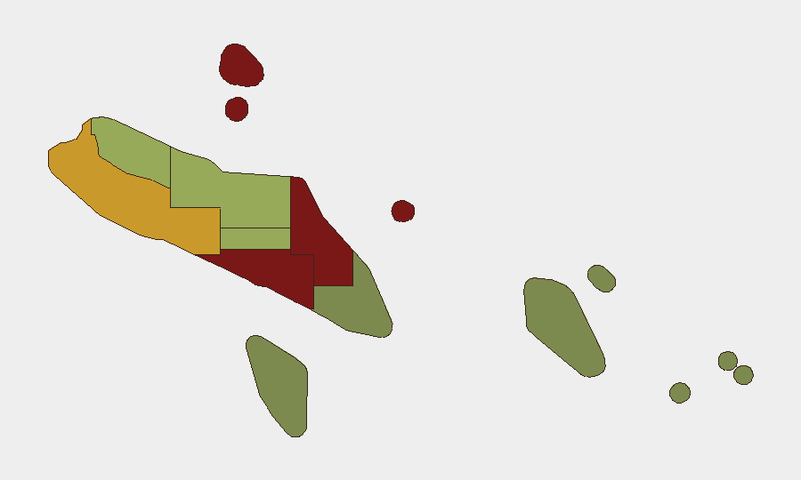
Highest-Risk Areas
Honiara (risk 92) and Guadalcanal Province (risk 88) account for the highest composite threat scores, driven primarily by urban crime, gang activity, and governance fragility rather than organized conflict or terrorism. Malaita (risk 85) follows as the third-highest-risk province, reflecting similar chronic crime and communal tension dynamics. Western Province (risk 72) and Choiseul (risk 58) carry moderate elevation. The remaining provinces—Isabel, Central, Makira-Ulawa, Rennell and Bellona, and Temotu—present significantly lower composite risks, reflecting lower population density, reduced criminal infrastructure, and greater stability. Risk concentration in the capital and larger urban centers is typical for Solomon Islands and reflects employment of personnel and asset presence rather than national-level instability.
How GeoBit Would Assist
Security teams with personnel or assets in Solomon Islands should employ AOI Monitoring & Early Warning on Honiara and Guadalcanal to detect emerging unrest, crime spikes, or civil disorder in real time; Intel Sweep and multi-language OSINT to track local media, social platforms, and government statements for policy shifts or security announcements; and Risk & Threat Assessment to establish baseline staffing, movement protocols, and duty-of-care thresholds tailored to sub-national risk tiers. Routing & Network Analysis is useful for journey planning and identification of alternative transport routes during any future disruption.
7-Day Outlook
No significant security escalation is forecast for the 7-day period ahead. The environment is expected to remain stable at current risk levels, with chronic urban crime and governance constraints continuing as primary drivers of concern rather than acute incidents. Continued monitoring of diplomatic communications and local news sources is advised as a precaution.
Highest-Risk Areas — Ranked
| # | State / Region | Risk |
|---|---|---|
| 1 | Honiara | 92 |
| 2 | Guadalcanal | 88 |
| 3 | Malaita | 85 |
| 4 | Western | 72 |
| 5 | Choiseul | 58 |
| 6 | Isabel | 52 |
| 7 | Central Province | 48 |
| 8 | Makira-Ulawa | 38 |
| 9 | Rennell and Bellona | 22 |
| 10 | Temotu | 18 |
Sources
Previous Daily Briefs
A new Solomon Islands brief is written every day — each with its own risk map and downloadable CSV. Here's the last week; use the calendar to go further back.
📅 Browse every day by calendar →
Highlighted days have a brief. Tap a day for that day's map & analysis, or “csv” for that day's dataset ($5).