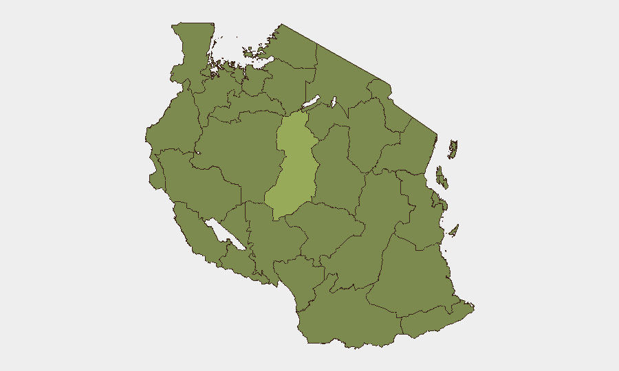
Situation Summary
Tanzania remains a mid-range regional security environment (global rank #52, composite threat score 36/100) with contained but geographically concentrated risks. The past 48 hours have not yielded confirmed, cross-verified incident reports from accessible sources; however, platform signals indicate ongoing diplomatic friction (Kenya border tension, African Union and European statements as of 19 June) and environmental stress from active wildfires. The overall trajectory is stable with localized volatility, particularly in pastoral and resource-extraction zones.
Key Developments
- 2026-06-18 | Border Tension | Kenya–Tanzania Dispute: Occupy Territory event recorded; nature and scale not independently confirmed in available web sources. Warrants close monitoring of Tanzanian-Kenyan border zones (northern regions: Kagera, Mara, Arusha) for escalation signals.
- 2026-06-19 | Diplomatic Statements | African Union & European Union: Public statements directed at Tanzania recorded; underlying cause and content not accessible in current research. Suggests potential governance, trade, or human-rights friction requiring context briefing from institutional channels.
- 2026-06-18 | Company-Level Rejection Event: Corporate entity on record as having rejected a proposal or engagement; operational context unclear and may fall outside security scope depending on nature.
- Recent | Environmental Hazard | Wildfires (Events 1028959, 1028919, 1028933): Multiple active wildfires detected; exact locations and threat-to-asset proximity not specified in current data. Likely to affect air quality, transport routes, and pastoral zones, particularly in central/western regions.
Note: No confirmed incidents of civil unrest, acute criminal activity, infrastructure failure, or travel impediment have been identified in the last 24–48 hours from publicly available, cross-verified sources. Security teams with on-ground presence should verify all diplomatic and environmental signals through local partners and institutional channels before modifying duty-of-care posture.
Highest-Risk Areas
Singida Region stands as the dominant risk driver (score 53.8), significantly outpacing the rest of the country; operational drivers (pastoralist tension, resource competition, or pre-existing conflict dynamics) are not detailed in available reporting and require targeted intelligence collection. Dar es-Salaam (26.1) reflects urban crime and maritime-adjacent risks typical of East Africa's largest port and commercial hub. Ten regions cluster at 23.8, including western border zones (Kigoma, Kagera, Geita, Katavi, Rukwa) and central/pastoral areas (Mwanza, Shinyanga, Tabora, Mara), suggesting distributed low-to-moderate risk rather than a single hotspot. Northern Singida's outlier status warrants dedicated area-of-interest monitoring.
How GeoBit Would Assist
Security teams should deploy AOI Monitoring & Early Warning with persistent satellite and OSINT watch on Singida Region, northern borders (Kagera, Mara), and Dar es-Salaam port to capture escalation signals before they mature into duty-of-care events. Intel Sweep (multi-language OSINT fusion, X/Telegram, sentiment analysis) coupled with Network & Actor Analysis would identify key stakeholders and rhetoric shifts around the Kenya dispute and diplomatic statements in near real time. Routing & Network Analysis enables alternative journey planning for staff transiting high-risk regions should wildfire or border activity restrict primary corridors.
7-Day Outlook
No major escalation is expected in the next seven days based on current signals, though the Kenya border friction and diplomatic statements warrant daily tracking. Wildfires are likely to persist in central/western zones, creating logistical friction rather than direct security threats. Singida Region remains the primary surveillance priority; any uptick in incident reporting there would signal a shift in the composite threat trajectory.
Highest-Risk Areas — Ranked
| # | State / Region | Risk |
|---|---|---|
| 1 | Singida Region | 53.8 |
| 2 | Dar es-Salaam | 26.1 |
| 3 | Kigoma Region | 23.8 |
| 4 | Kagera | 23.8 |
| 5 | Mwanza Region | 23.8 |
| 6 | Geita | 23.8 |
| 7 | Shinyanga Region | 23.8 |
| 8 | Tabora Region | 23.8 |
| 9 | Katavi Region | 23.8 |
| 10 | Rukwa Region | 23.8 |
| 11 | Songwe Region | 23.8 |
| 12 | Mara Region | 23.8 |
Sources
Previous Daily Briefs
A new Tanzania brief is written every day — each with its own risk map and downloadable CSV. Here's the last week; use the calendar to go further back.
📅 Browse every day by calendar →
Highlighted days have a brief. Tap a day for that day's map & analysis, or “csv” for that day's dataset ($5).