Situation Summary
Togo remains stable in the 24–48-hour window through 26 July 2026, with no independently verified security incidents (attacks, armed clashes, major unrest) reported in the last two days. The country's overall threat composite score of 26 reflects structural vulnerabilities rather than acute, active conflict; however, severe regional disparities persist, with the northern Savanes and Kara regions classified as high-risk due to sustained insurgent and militant pressure originating from the Sahel corridor. Corporate and field personnel should maintain heightened vigilance in the north while treating the southern and central regions as lower-risk, though not incident-free.
Key Developments
- No independently confirmed incident-level security events in Togo during the 24–48-hour window ending 26 July 2026 across open-source news feeds, regional security briefs, or OSINT platforms. The absence of reportable incidents reflects a period of relative operational quiet.
- Persistent Savanes and Kara Region risk. Underlying threat drivers in the northern two regions (ranked at risk scores 92 and 78, respectively) remain unresolved; long-running insurgent activity and cross-border militant spillover from Burkina Faso and Mali continue to elevate baseline risk, though no acute clashes or mass-casualty incidents have been time-stamped to the last 48 hours.
- Foreign security presence (longer-term context, not a 24–48h incident). Togo has hosted expanded foreign military support and Africa Corps deployments earlier in July; this structural development underpins the security posture but does not constitute a discrete incident in the current window.
Highest-Risk Areas
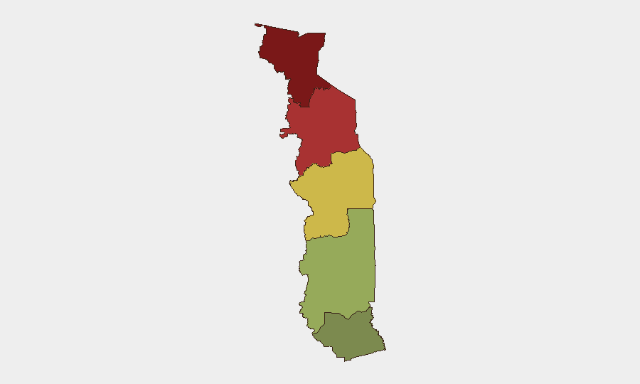
The Savanes Region (score 92) and Kara Region (score 78) account for the vast majority of Togo's residual threat. Both are contiguous to or proximate to active militant zones in Burkina Faso and Mali, creating sustained infiltration, recruitment, and weapon-smuggling vectors. The Centrale (65) and Plateaux (45) regions show moderate-to-low-moderate exposure, while the Maritime Region (28)—which includes the capital Lomé and commercial corridors—is the lowest-risk zone. Any escalation in northern Togo would likely originate in Savanes or Kara and propagate south over weeks to months, not hours.
How GeoBit Would Assist
Teams with personnel or assets in Togo should deploy Intel Sweep and multi-language OSINT feeds to monitor Savanes and Kara regions for early signals of cross-border incursion or militant activity; AOI Monitoring & Early Warning with persistent, geofenced watch on high-risk northern districts would provide automated alerting of new incidents or movement anomalies. Conflict & Military force-structure and battle-mapping tools allow near-real-time assessment of actor location and capability in the Sahel, enabling duty-of-care teams to anticipate risk before it materializes locally. Routing & Network Analysis can identify secure travel corridors and contingency evacuation paths, especially for road-based operations in the Centrale and Plateaux regions.
7-Day Outlook
Over the next seven days, Togo is expected to remain in a holding pattern—no acute triggers are visible on the horizon, but underlying northern instability and cross-border militant pressure will persist. Any significant deterioration would likely be preceded by 48–72 hours of precursor activity (weapons caches found, recruitment surge, opposition rhetoric escalation), for which persistent monitoring is essential. Corporate security postures should remain calibrated to the north-south risk gradient rather than shifted to widespread alert.
Highest-Risk Areas — Ranked
| # | State / Region | Risk |
|---|---|---|
| 1 | Savanes Region | 92 |
| 2 | Kara Region | 78 |
| 3 | Centrale Region | 65 |
| 4 | Plateaux Region | 45 |
| 5 | Maritime Region | 28 |
Sources
Previous Daily Briefs
A new Togo brief is written every day — each with its own risk map and downloadable CSV. Here's the last week; use the calendar to go further back.
📅 Browse every day by calendar →
Highlighted days have a brief. Tap a day for that day's map & analysis, or “csv” for that day's dataset ($5).
Atlas — our AI intelligence desk — emails them this snapshot personally. Nothing else, no list.