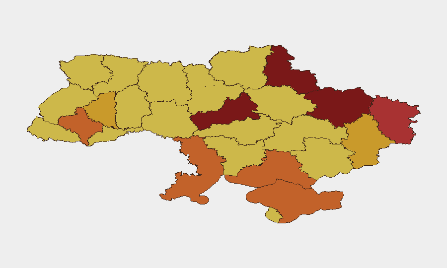
Situation Summary
Ukraine remains the world's second-highest-threat environment (composite score 100) with 556 tracked events in the current cycle, driven by sustained conventional and aerial warfare across multiple fronts. The past 24–48 hours have registered intensifying drone and missile strikes, tactical ground advances and reversals in eastern sectors, and rising civilian casualty trends. The conflict trajectory shows no sign of de-escalation; Russian forces continue large-scale strike operations while Ukrainian counterattacks demonstrate localized gains, sustaining a high-intensity, protracted war footing.
Key Developments
- Kharkiv Oblast, 14 Jun 2026: Russian forces conducted coordinated attacks on Kharkiv city and 12 surrounding settlements, injuring three civilians including a teenager and damaging residential infrastructure.
- Sumy city, 12 Jun 2026: Long-range Russian artillery shelling injured six residents and damaged buildings; this marks the third confirmed artillery strike on Sumy city in 2026, indicating sustained targeting of population centers.
- Nationwide, night of 11–12 Jun 2026: Russian forces launched 117 strike drones (Shahed, Gerbera, Italmas models) and decoy drones from Russian territory and occupied Crimea—one of the largest recent drone waves—striking targets across Ukraine.
- Kostyantynivka, Donetsk Oblast, 12 Jun 2026: Russian forces achieved tactical ground gains; Ukrainian defenses in the southeastern sections assessed as deteriorating, reflecting high-intensity ground combat.
- Kostyantynivka–Druzhkivka and Oleksandrivka directions, 12 Jun 2026: Ukrainian forces reported recent advances in both tactical areas, indicating localized counteroffensives and fluid front-line conditions.
- Nationwide, 12 Jun 2026: Ukrainian Air Force issued warning of "high probability" Russian Oreshnik intermediate-range ballistic missile (IRBM) launch from Kapustin Yar (Astrakhan Oblast) within 24–48 hours, elevating short-term nationwide missile-strike risk.
- Civilian casualties, May 2026: UN political chief reported that civilian casualties in May exceeded April levels, signaling intensifying drone and missile attacks and deadlier overall conflict environment.
Highest-Risk Areas
Kyiv (risk 100) remains the dominant threat driver due to its status as capital, political target, and population concentration; it faces sustained aerial and missile threat. The northeastern and eastern oblasts—Kharkiv (83.1), Sumy (80.5), Luhansk (77.7), and Donetsk (72.5)—dominate the operational landscape, hosting active front lines, ground combat, and civilian-area artillery/drone strikes. Cherkasy (85.3), though inland, ranks second owing to proximity to Russian-held territory and vulnerability to long-range strikes. The western and southern oblasts (Lviv, Ivano-Frankivsk, Odesa, Kherson) remain elevated but secondary to the eastern concentration of kinetic activity.
How GeoBit Would Assist
Security and risk teams would deploy AOI Monitoring & Early Warning on personnel locations and asset sites in high-risk oblasts (Kharkiv, Sumy, Kyiv, Donetsk) for persistent threat alerting tied to drone/missile launch patterns and ground advances. Battle Mapping, Force Structure, and Weapons-Capability Tracking provide real-time understanding of front-line positions and Russian strike asset deployment, enabling duty-of-care route planning and evacuation decisions. Intel Sweep and multi-language OSINT fusion (Telegram, Ukrainian state emergency service feeds, Ukrainian Air Force advisories) supply corroborated tactical warning of specific strikes 24–48 hours in advance, as exemplified by the Oreshnik IRBM alert.
7-Day Outlook
Expect continued large-scale drone and missile strikes nationwide, with elevated probability of IRBM employment in the next 48 hours. Ground combat will likely remain intense in the eastern sectors (Kostyantynivka–Druzhkivka, Oleksandrivka), with tactical shifts but no major front-line collapse forecast. Civilian casualty trends and infrastructure damage will persist, maintaining operational constraints on movement and shelter availability across high-risk oblasts.
Highest-Risk Areas — Ranked
| # | State / Region | Risk |
|---|---|---|
| 1 | Kyiv | 100 |
| 2 | Cherkasy Oblast | 85.3 |
| 3 | Kharkiv Oblast | 83.1 |
| 4 | Sumy Oblast | 80.5 |
| 5 | Luhansk Oblast | 77.7 |
| 6 | Kherson Oblast | 75.2 |
| 7 | Ivano-Frankivsk Oblast | 74.1 |
| 8 | Odesa Oblast | 74.1 |
| 9 | Autonomous Republic of Crimea | 73.6 |
| 10 | Donetsk Oblast | 72.5 |
| 11 | Ternopil Oblast | 71.2 |
| 12 | Lviv Oblast | 70.8 |
Sources
Previous Daily Briefs
A new Ukraine brief is written every day — each with its own risk map and downloadable CSV. Here's the last week; use the calendar to go further back.
📅 Browse every day by calendar →
Highlighted days have a brief. Tap a day for that day's map & analysis, or “csv” for that day's dataset ($5).