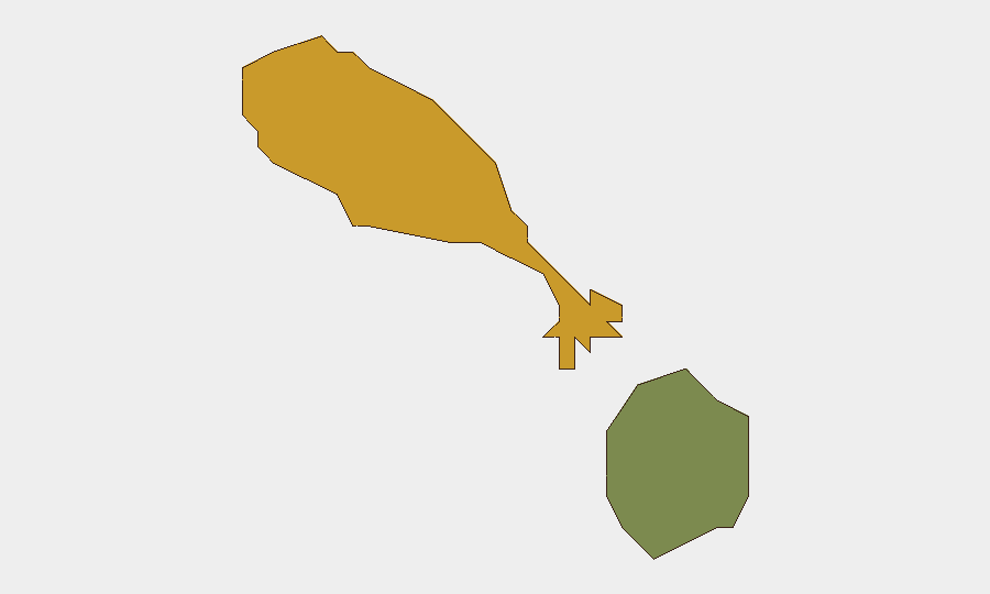
Situation Summary
Saint Kitts and Nevis remains a low-threat jurisdiction (#123 globally) with crime and gang activity as the primary security driver. No domestic violent crime, civil unrest, or travel disruption events were substantiated during October 6–13. The federation's security posture appears stable, though Saint Kitts island carries substantially elevated risk (72) compared to Nevis (28), reflecting persistent underlying crime patterns.
Key Developments
- October 7, Nevis — Power Outage: An emergency blackout began at approximately 4:16 a.m. following detection of a fault at the island's power plant. Scope and restoration timeline were not detailed in available reporting.
- October 7–9, Saint Kitts (NEMA Compound) — Disaster Preparedness Training: National Emergency Management Agency authorities conducted field-hospital setup and mass-casualty response training, signaling active contingency planning for potential public-health or disaster scenarios.
- October 5, reported October 8–12 — Maritime Incident (Black Sea/Romania): The Saint Kitts and Nevis–flagged cargo vessel *Royad Mammadov* was struck, caught fire, and sank while transiting from Ukraine to Italy; two crew members died and 11 were rescued. While the incident occurred outside the federation's waters, it carries reputational and maritime-registry implications.
- October 7–11, Saint Kitts and Nevis Government — Diplomatic Statement: The federation issued a formal call to the Organization of American States for restoration of civil liberties in Nicaragua, including release of political prisoners. This was a regional diplomatic action with no domestic security nexus.
Highest-Risk Areas
Saint Kitts (composite risk score 72) is the clear risk concentration, driven by underlying crime and gang activity; Nevis (28) is materially lower-risk. The disparity reflects Saint Kitts' larger population, urban density, and historical crime patterns. Security teams with personnel or assets on Saint Kitts should maintain heightened situational awareness and standard crime-mitigation protocols (restricted movement patterns, secure transportation, low profile); Nevis presents routine baseline risk suitable for standard duty-of-care measures.
How GeoBit Would Assist
Security teams should employ AOI Monitoring & Early Warning on Saint Kitts (and secondary watch on Nevis) to detect emerging violence, gang activity, or civil unrest in real time. Multi-language OSINT (X/Twitter, Telegram, local news feeds) combined with sentiment & temporal analysis enables early detection of community friction or protest activity before escalation. Maritime & Aviation tracking provides advance notice of vessel or personnel movements, supporting evacuation or asset-redeployment planning if domestic conditions deteriorate.
7-Day Outlook
No acute security deterioration is forecast for the next 7 days. The power outage on Nevis appears to have been a technical fault with no civil-unrest dimension. Underlying crime and gang activity in Saint Kitts are chronic rather than acute; no intelligence suggests imminent organized-violence clusters or gang-war escalation. Standard monitoring posture and duty-of-care protocols should remain in effect.
Highest-Risk Areas — Ranked
| # | State / Region | Risk |
|---|---|---|
| 1 | Saint Kitts | 72 |
| 2 | Nevis | 28 |
Sources
Previous Weekly Briefs
A new Saint Kitts and Nevis brief is written every Monday, covering the week — each with its own risk map and downloadable CSV. Use the calendar to go further back.
- October 6, 2026
- September 29, 2026
- September 22, 2026
- September 15, 2026
- September 8, 2026
- September 1, 2026
- August 29, 2026
📅 Browse past briefs by calendar →
Highlighted days have a brief. Tap a day for that day's map & analysis, or “csv” for that day's dataset ($5).
Atlas — our AI intelligence desk — emails them this snapshot personally. Nothing else, no list.