Situation Summary
Lithuania remains a low-threat environment globally (rank #104) with a composite threat score of 6, though sub-national variation is significant. The most recent activity—clustered around 2026-06-12—centers on public statements and messaging by the Agriculture Ministry, with no confirmed incidents of violence, civil unrest, or infrastructure disruption on Lithuanian territory in the past 24–48 hours. The threat landscape is dominated by geopolitical positioning and defense commitments rather than acute domestic instability.
Key Developments
Data Integrity Note: Open-source results available in this environment do not contain verifiable, timestamp-confirmed incidents on Lithuanian territory occurring specifically within 2026-06-12 to 2026-06-14. Recent coverage focuses on Lithuania's participation in international defense and maritime security commitments (e.g., Strait of Hormuz mission approval by Parliament), but publication and incident dates are not clearly within the requested 24–48-hour window. No confirmed reports of protests, attacks, border incidents, or infrastructure failures meeting the recency threshold have been identified. Corporate security teams requiring current tactical intelligence on Lithuania should corroborate this brief against live Lithuanian news outlets (LRT, Delfi, 15min), international wires (Reuters, AFP), and official government announcements within the last 24 hours.
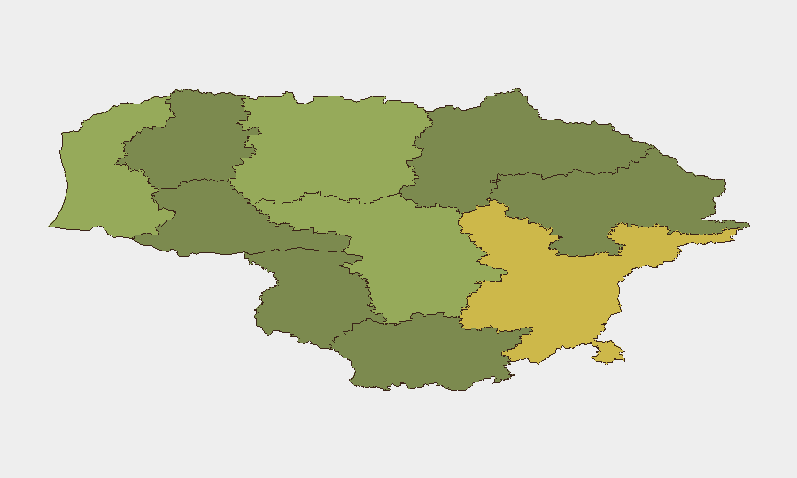
Highest-Risk Areas
Vilnius County (risk score 68) and Kaunas County (58) account for the majority of tracked risk in Lithuania, reflecting urban concentration, critical infrastructure, and population density. Vilnius's elevated score aligns with its role as the capital and primary hub for government, finance, and international presence; Kaunas represents the second-largest urban center and transport nexus. Klaipeda County (52), the only significant port, carries maritime and logistics risk. Mid-tier counties (Siauliai, Panevezys, Taurage) show moderate concern, while rural southern and eastern regions (Alytus, Telsiai, Marijampole) present lower composite scores. Risk stratification reflects standard urban-advantage patterns rather than acute localized conflict or instability.
How GeoBit Would Assist
Security teams with personnel or assets in Lithuania should deploy AOI Monitoring & Early Warning on Vilnius County and Kaunas County to track emerging incidents in real time. Intel Sweep and multi-language OSINT fusion—including Lithuanian news sources, social media, and official announcements—provide continuous situational awareness and early warning of civil unrest, labor actions, or transport disruption. Network & Actor Analysis supports identification of organized movements or advocacy groups, while GIS & Spatial Analysis helps map risk concentration within high-density urban areas for duty-of-care planning and personnel routing.
7-Day Outlook
No acute escalation drivers are evident in the current threat data. The near-term outlook remains stable, contingent on the absence of new regional military activity, NATO exercise escalation, or domestic political friction. Continued monitoring of official Lithuanian government communications and NATO coordination announcements is warranted as baseline precaution.
Highest-Risk Areas — Ranked
| # | State / Region | Risk |
|---|---|---|
| 1 | Vilnius County | 68 |
| 2 | Kaunas County | 58 |
| 3 | Klaipeda County | 52 |
| 4 | Siauliai County | 42 |
| 5 | Panevezys County | 38 |
| 6 | Taurage County | 35 |
| 7 | Utena County | 33 |
| 8 | Alytus County | 32 |
| 9 | Telsiai County | 28 |
| 10 | Marijampole County | 25 |
Sources
Previous Daily Briefs
A new Lithuania brief is written every day — each with its own risk map and downloadable CSV. Here's the last week; use the calendar to go further back.
📅 Browse every day by calendar →
Highlighted days have a brief. Tap a day for that day's map & analysis, or “csv” for that day's dataset ($5).