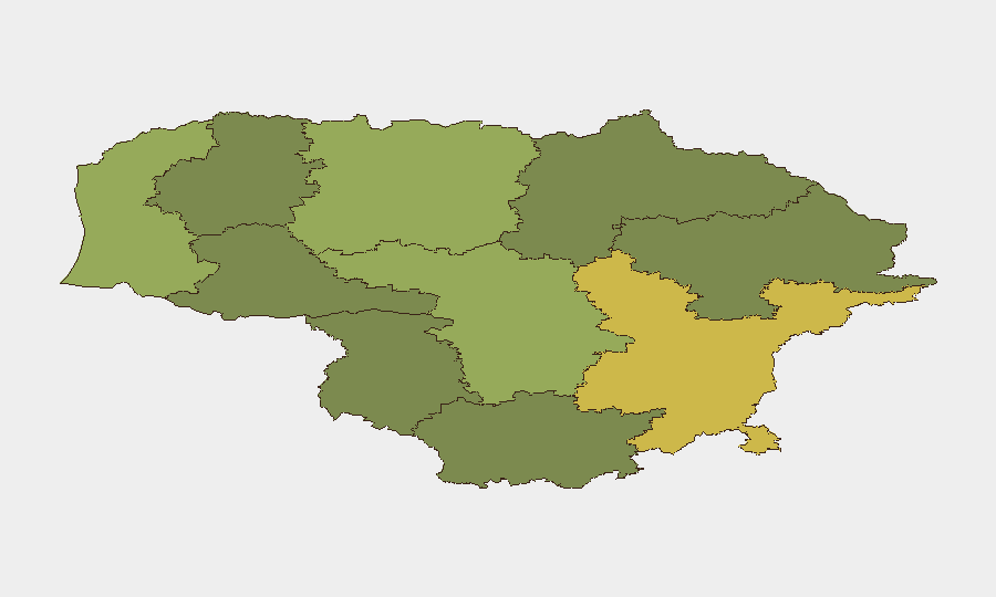
Situation Summary
Lithuania remains at low composite threat (rank #143 globally, score 11), with no tracked security incidents in the reporting week. However, border and airspace activity elevated this week in response to perceived Russian mobilisation concerns and aviation restrictions affecting Moscow-bound traffic. Risk remains concentrated in border counties and the capital region. The security posture reflects NATO membership deterrence and heightened vigilance rather than active internal instability.
Key Developments
- Kaliningrad Border — 7 October 2026: Lithuania approved deployment of up to 100 soldiers to augment border guard operations for several weeks in response to precautionary concerns about potential Russian mobilisation and possible hostile cross-border activity. Announcement reported by LRT with independent corroboration from TASS and The Moscow Times.
- Moscow-Bound Flight Diversions — 12–13 October 2026: Three flights from Turkey to Moscow reportedly reversed course over Lithuanian airspace following restrictions imposed at Moscow's Vnukovo Airport on 12 October; a fourth Antalya–Moscow service was reported to have diverted earlier the same day. Attribution sourced to TV3.lt; secondary confirmation pending.
- Vilnius County Airspace Closure — Prior Event (Background): An unidentified aerial object approached from Belarus on or around 3 October, triggering closure of Vilnius Airport (~50 minutes) and NATO fighter scramble; classified as strategic development in open reporting.
Highest-Risk Areas
Vilnius County (risk 68) and Kaunas County (risk 58) drive the majority of national composite risk, reflecting population density, critical infrastructure concentration, and proximity to Belarus and Russian Kaliningrad. Klaipeda County (risk 52) follows, likely reflecting Baltic Sea maritime exposure and NATO logistics activity. Border counties—particularly along the Belarus and Kaliningrad frontiers—face elevated risk from cross-border mobility, irregular migration pressure, and military activity; this week's soldier deployment to Kaliningrad-adjacent zones underscores operational concern in that corridor. Urban centres and transport hubs remain priority protection zones for corporate assets.
How GeoBit Would Assist
Security teams in Lithuania would leverage Intel Sweep and multi-language OSINT fusion to monitor border-region military activity and cross-border movement signals in near-real time. AOI Monitoring & Early Warning on Vilnius, Kaunas, and border crossings would provide persistent alerting on airspace restrictions, mobilisation indicators, and irregular entry patterns. Aviation tracking and Routing & Network Analysis capabilities enable duty-of-care teams to anticipate airspace closures and alternative flight/transit routing before passenger or supply-chain impact occurs.
7-Day Outlook
Border precautions are likely to remain in place through early-to-mid October pending clarification of Russian posture. Airspace restrictions affecting Moscow traffic may persist if Vnukovo operational issues continue. No significant escalation is forecast; the security environment reflects NATO deterrence and routine heightened awareness rather than imminent kinetic risk.
Highest-Risk Areas — Ranked
| # | State / Region | Risk |
|---|---|---|
| 1 | Vilnius County | 68 |
| 2 | Kaunas County | 58 |
| 3 | Klaipeda County | 52 |
| 4 | Siauliai County | 42 |
| 5 | Panevezys County | 38 |
| 6 | Taurage County | 35 |
| 7 | Utena County | 33 |
| 8 | Alytus County | 32 |
| 9 | Telsiai County | 28 |
| 10 | Marijampole County | 25 |
Sources
Previous Weekly Briefs
A new Lithuania brief is written every Monday, covering the week — each with its own risk map and downloadable CSV. Use the calendar to go further back.
- October 6, 2026
- September 29, 2026
- September 22, 2026
- September 15, 2026
- September 8, 2026
- September 1, 2026
- August 30, 2026
📅 Browse past briefs by calendar →
Highlighted days have a brief. Tap a day for that day's map & analysis, or “csv” for that day's dataset ($5).
Atlas — our AI intelligence desk — emails them this snapshot personally. Nothing else, no list.