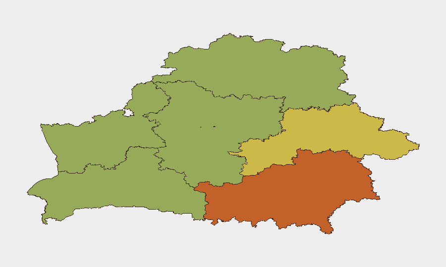
Situation Summary
Belarus remains a low-threat environment for general corporate security (global rank #147), but is experiencing elevated military and civil-defense activity driven by concurrent multinational CSTO exercises and a presidential readiness check. The exercises—counterterrorism, peacekeeping command-and-staff, and CBRN-defense drills—involve over 1,500 personnel, 300+ weapons systems, and approximately 80 drones across multiple regions. Border-area activity and the involvement of internal security forces alongside military units reflect a heightened operational posture, particularly in western and northern oblasts, though no incidents affecting civilian infrastructure or personnel have been reported this week.
Key Developments
- Minsk, Chizhovka Arena and Chizhovka Reservoir (7–8 October): The CIS–SCO Eurasia-Antiterror 2026 forum and live-exercise phase concluded, including simulated attacks on critical facilities, hostage rescue operations, and drone-activity scenarios over the reservoir. Security forces conducted counter-infiltration and anti-sabotage operations using both manned and unmanned systems.
- Vitsebsk Oblast, Losvid training area (11–12 October): The CSTO launched Indestructible Brotherhood 2026, a multinational peacekeeping command-and-staff exercise involving Belarus, Russia, Kazakhstan, Kyrgyzstan, and Tajikistan. The exercise expanded to over 1,500 personnel, 300+ weapons and equipment systems, and approximately 80 drones by 12 October.
- Staryya Darohi, Minsk Region (11–12 October): The CSTO initiated Barrier 2026, a specialized radiation, chemical, and biological-defense exercise involving protection and medical-support units across multiple nations.
- Belarus-wide, reported focus near Hrodna (12 October): President Lukashenka ordered a surprise readiness check of a battalion from the 6th Separate Guards Mechanized Brigade, with activity reported near the Belarus–Poland border, signaling heightened military preparedness in the western border zone.
- Vitsebsk Oblast (12 October): Concurrent CSTO drills expanded significantly, incorporating western and northern security areas with Belarusian riot police and internal troops operating alongside military units, adding a domestic civil-order component to exercises bordering Latvia and Lithuania.
Highest-Risk Areas
Homyel Region (risk 75) and Minsk (risk 68) remain the highest-risk sub-national areas, reflecting proximity to the Russian border and Ukraine conflict, combined with capital-city critical-infrastructure density. Mahilyow Region (risk 62) and Brest Region (risk 55) follow, while the exercise activity this week concentrated in Vitsebsk Oblast (risk 45, northern) and near Hrodna (Hrodna Region risk 52, western), both bordering NATO states. The western and northern zones appear to be the current operational focus for military readiness and drill activity, though the composite rankings reflect longer-term geopolitical and infrastructure factors rather than immediate incident likelihood.
How GeoBit Would Assist
Security and risk teams should deploy AOI Monitoring & Early Warning on Homyel Region, Minsk, and the active exercise zones (Vitsebsk, Hrodna) to track military and drill activity with persistent alerting. Conflict & Military capabilities—force structure, weapons-capability tracking, and battle mapping—provide real-time visibility into CSTO and Belarusian Armed Forces deployment and equipment during exercises. Satellite & Imagery Analysis and GIS & Spatial Analysis can identify critical infrastructure in high-risk regions and validate the geographic scope of operational activity for duty-of-care planning.
7-Day Outlook
The concurrent CSTO and domestic readiness exercises are scheduled to continue through mid-to-late October; no major civil disruptions are anticipated, but military activity will remain elevated in western and northern oblasts through the exercise cycle. Border-area monitoring and drone activity—demonstrated during the exercises—suggest sustained vigilance for airspace incursions; corporate operations near Hrodna, Vitsebsk, or the Lithuanian/Latvian borders should expect periodic military traffic and possible temporary airspace restrictions.
Highest-Risk Areas — Ranked
| # | State / Region | Risk |
|---|---|---|
| 1 | Homyel Region | 75 |
| 2 | Minsk | 68 |
| 3 | Mahilyow Region | 62 |
| 4 | Brest Region | 55 |
| 5 | Hrodna Region | 52 |
| 6 | Minsk Region | 48 |
| 7 | Vitsebsk Region | 45 |
Sources
Previous Weekly Briefs
A new Belarus brief is written every Monday, covering the week — each with its own risk map and downloadable CSV. Use the calendar to go further back.
- October 6, 2026
- September 29, 2026
- September 22, 2026
- September 15, 2026
- September 8, 2026
- September 1, 2026
- August 30, 2026
📅 Browse past briefs by calendar →
Highlighted days have a brief. Tap a day for that day's map & analysis, or “csv” for that day's dataset ($5).
Atlas — our AI intelligence desk — emails them this snapshot personally. Nothing else, no list.