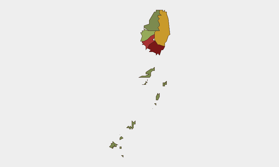
Situation Summary
Saint Vincent faces a dual security challenge this week: underlying violent crime (including a fatal mass shooting on 25 September and subsequent arrests) has been overshadowed by a severe natural-hazard event. Heavy rainfall from a tropical wave between 6–11 October triggered 154 verified incidents nationwide, including widespread flooding, landslides, and critical infrastructure damage. The National Emergency Management Organisation activated its Emergency Operations Center on 9–12 October. Overall threat ranking remains moderate globally (#136), but sub-national variation is pronounced, with Saint George posing significantly elevated risk.
Key Developments
- Saint Vincent (nationwide), 6–11 October: Tropical wave produced torrential rainfall exceeding 5 inches in 24 hours, triggering nationwide school closures and widespread flooding and landslides that blocked roads and isolated communities.
- Buccament, 6 October: Floodwaters trapped residential families; rescue operations successfully extracted residents and relocated them to safety.
- Saint Vincent (nationwide), 9–12 October: National Emergency Management Organisation activated the National Emergency Operations Center following 154 verified incidents across the country stemming from the tropical weather event.
- Saint Vincent (nationwide), 6 October: A flooded hospital and multiple school closures were reported as critical infrastructure sustained water damage; continued rainfall prolonged disruption through 11 October.
- Green Hill, 25 September (background context): A mass shooting killed four civilians and wounded four others; incident remains under active investigation. On 26 September, police arrested two suspects, recovered a Glock 19 pistol and ammunition, and both were denied bail pending adjournment.
- Riviere, 8 October: Police arrested and charged a 26-year-old office clerk with property damage; the alleged incident itself occurred on 23 July, so does not represent new criminal activity this week.
- Saint Vincent (nationwide), 6 October: National Security Minister St Clair Leacock publicly stated that government finances are constrained and called for greater transparency in public spending and infrastructure management, signalling potential capacity limits for emergency response.
Highest-Risk Areas
Saint George (risk 92) is the dominant flashpoint, followed by Saint Andrew (78) and Charlotte (71), collectively accounting for the majority of tracked violent incidents and property crime. The 25 September mass shooting near Green Hill (in Saint George) and subsequent arrest operations underscore persistent gun violence in the capital region. Saint Patrick (58) poses moderate risk. The Grenadines, by contrast, register minimal risk (12), suggesting that security concerns are concentrated on mainland Saint Vincent's urban and periurban zones.
How GeoBit Would Assist
Teams managing personnel or assets in Saint Vincent should employ AOI Monitoring & Early Warning to track Saint George, Saint Andrew, and Charlotte for emerging crime signals; Environmental & Health capabilities to integrate tropical weather alerts with infrastructure vulnerability; and Risk & Threat Assessment to correlate flooding disruption with potential crime upticks during recovery phases. GIS & Spatial Analysis can map flooded zones, landslide corridors, and alternative routing for supply chains and personnel movement.
7-Day Outlook
Weather systems are expected to clear by mid-week; however, secondary hazards (flooded roadways, compromised utilities, landslide debris) will persist. Recovery operations may strain local security resources, and isolated or damaged infrastructure could create transient security gaps in high-risk parishes. Monitoring for opportunistic crime and civil unrest during the recovery phase is advisable.
Highest-Risk Areas — Ranked
| # | State / Region | Risk |
|---|---|---|
| 1 | Saint George | 92 |
| 2 | Saint Andrew | 78 |
| 3 | Charlotte | 71 |
| 4 | Saint Patrick | 58 |
| 5 | Saint David | 34 |
| 6 | Grenadines | 12 |
Sources
Previous Weekly Briefs
A new Saint Vincent brief is written every Monday, covering the week — each with its own risk map and downloadable CSV. Use the calendar to go further back.
- October 5, 2026
- September 28, 2026
- September 21, 2026
- September 14, 2026
- September 7, 2026
- September 1, 2026
- August 30, 2026
📅 Browse past briefs by calendar →
Highlighted days have a brief. Tap a day for that day's map & analysis, or “csv” for that day's dataset ($5).
Atlas — our AI intelligence desk — emails them this snapshot personally. Nothing else, no list.