Situation Summary
The Bahamas remains a stable destination with moderate underlying crime challenges concentrated in Nassau and Freeport. National crime statistics are trending downward year-to-date, though isolated violent incidents—including a shooting in Fox Hill on 2026-08-24—persist in high-risk urban pockets. Illegal firearms trafficking is acknowledged by national security officials as the primary driver of localized violence, with ongoing law-enforcement operations targeting weapons removal from circulation.
Key Developments
- Nassau, Fox Hill (Reeves Street) — 2026-08-24: Armed assailants fired on a group outside a residential building, resulting in two men hospitalized. This incident exemplifies the sporadic but recurring gun violence affecting inner-city Nassau neighborhoods.
- Bahamas-wide — 2026-08-27: The National Security Minister publicly identified illegal firearms trafficking as a critical threat multiplier during a regional workshop on criminal investigations and prosecutions, signaling continued governmental focus on weapons interdiction.
- Bahamas-wide — 2026-08-25 to 2026-08-27: Official statements confirmed that overall crime counts remain below year-prior levels despite a weekend that included three homicides, suggesting volatile but statistically improving conditions.
- Grand Cay, Abaco — 2026-08-27 to 2026-08-28: Bahamas Power and Light restored electricity after three weeks of outages in this Family Islands community and issued customer credits. While not a security incident, infrastructure disruptions can amplify operational and duty-of-care risks for corporate assets and personnel.
Highest-Risk Areas
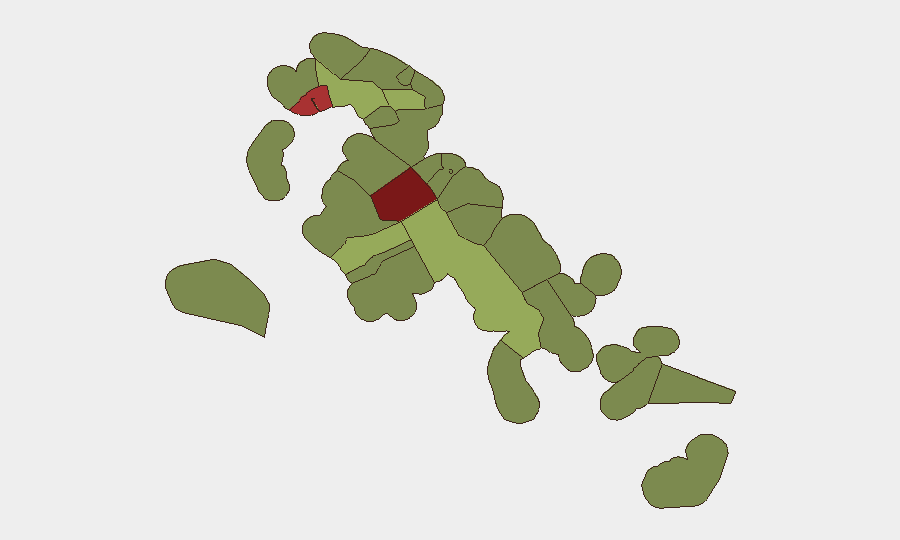
New Providence (composite risk 92) and the City of Freeport (78) account for the vast majority of documented criminal activity and carry substantially elevated risk relative to the rest of the archipelago. Central Abaco (52) shows secondary concern, driven by spillover effects and geographic isolation that can complicate response times. The Family Islands and outer settlements—Exuma, Eleuthera, Cat Island, and the Andros chain—present significantly lower risk profiles (28–45), though infrastructure vulnerabilities and distance from major medical and emergency services remain operational considerations for dispersed teams.
How GeoBit Would Assist
GeoBit's AOI Monitoring & Early Warning capability would enable persistent watch over New Providence and Freeport, with automated alerting on emerging crime clusters or weapons-trafficking activity. Intel Sweep (X/Twitter, Telegram OSINT, YouTube intelligence, and multi-language feeds) combined with Network & Actor Analysis would track trafficking networks and criminal organization movements in real time. For personnel and asset protection, Routing & Network Analysis supports alternative journey planning and congestion avoidance in high-incident neighborhoods, while Environmental & Health monitoring flags infrastructure disruptions—such as power outages—that could degrade security posture or emergency response capability.
7-Day Outlook
No specific escalation indicators are present for the next seven days. Seasonal patterns and holiday periods (if applicable) should be monitored for upticks in transient crime or opportunistic theft. Continued focus by national law enforcement on firearms seizures and trafficking networks may temporarily increase police visibility in New Providence and Freeport, which could suppress reported incidents or displace risk to adjacent areas; sustained vigilance is warranted rather than assumption of improvement.
Highest-Risk Areas — Ranked
| # | State / Region | Risk |
|---|---|---|
| 1 | New Providence | 92 |
| 2 | City of Freeport | 78 |
| 3 | Central Abaco | 52 |
| 4 | Central Andros | 48 |
| 5 | Exuma | 45 |
| 6 | East Grand Bahama | 42 |
| 7 | South Andros | 38 |
| 8 | North Abaco | 35 |
| 9 | North Eleuthera | 33 |
| 10 | South Abaco | 32 |
| 11 | Cat Island | 30 |
| 12 | Mangrove Cay | 28 |
Sources
Previous Daily Briefs
A new Bahamas brief is written every day — each with its own risk map and downloadable CSV. Here's the last week; use the calendar to go further back.
- August 27, 2026
- August 25, 2026
- August 23, 2026
- August 21, 2026
- August 19, 2026
- August 17, 2026
- August 15, 2026
📅 Browse every day by calendar →
Highlighted days have a brief. Tap a day for that day's map & analysis, or “csv” for that day's dataset ($5).
Atlas — our AI intelligence desk — emails them this snapshot personally. Nothing else, no list.