Situation Summary
Barbados remains a low-threat jurisdiction globally (rank #183, composite score 4) with no tracked discrete security events in the current reporting period. However, localized violence—primarily homicide and traffic fatalities—continues in high-density urban parishes, particularly Saint Michael and Saint George. The absence of organized criminal events, terrorism indicators, or major civil unrest suggests the operating environment remains permissive for business and personnel movement, though street-level incident risk warrants parish-level awareness.
Key Developments
- Six Roads, Saint Philip — 27 September, 02:30 hrs: Fatal shooting of a driver in a parked vehicle; police investigation ongoing and witnesses sought. This represents the only confirmed lethal violence event in the seven-day window.
- Deacons Farm, Saint Michael — 23 September: Police arrested Jason Errol Chapman on cannabis cultivation charges following discovery of approximately 2 kg of cannabis in his backyard (estimated street value BDS$10,000). Indicates continued low-level drug cultivation activity in urban parishes.
- Highway 2A–Ronald Mapp Highway, Saint Thomas — 22–29 September, overnight hours: Southbound lane closure and traffic diversion during milling and paving works; project expected to continue approximately three weeks. Relevant for route planning and personnel commute disruption.
- Walkers Road, Saint George — 22 September, 18:15 hrs (boundary date): A 61-year-old pedestrian fatally struck by a public-service vehicle; police investigation opened. *Note: incident date falls outside the seven-day window but is included as a recent fatality indicator in high-risk Saint George.*
Highest-Risk Areas
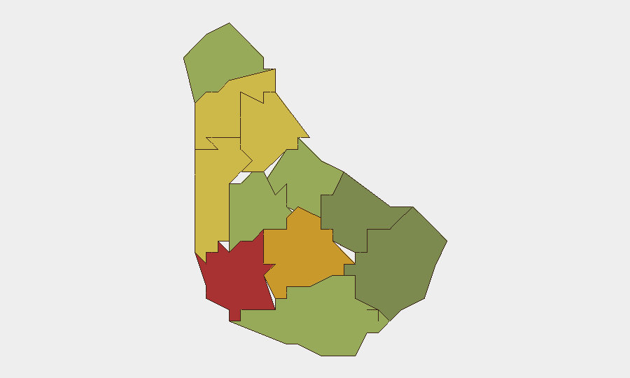
Saint Michael (risk 78) and Saint George (risk 72) are the primary drivers of Barbados's sub-national threat profile, followed by Saint James (68) and Saint Andrew (65). All four parishes are concentrated in the western urban corridor, where population density, street-level violence (primarily homicide), and traffic fatality rates are elevated. Saint Michael, home to the capital Bridgetown, accounts for a disproportionate share of reported incidents. Conversely, southern and eastern parishes (Saint Philip, Saint John, Christ Church) show markedly lower risk scores, reflecting lower population density and reduced incident frequency. Risk concentration in the northwest urban band suggests targeted precautions for personnel or assets in those parishes.
How GeoBit Would Assist
Security teams operating in Barbados should employ AOI Monitoring & Early Warning to establish persistent watch on high-risk parishes (Saint Michael, Saint George, Saint James) with automated alerting on new homicide, armed robbery, or traffic incidents. Intel Sweep and X/Twitter & Telegram OSINT capabilities enable continuous monitoring of local criminal activity and civil sentiment, filling gaps in official reporting. Routing & Network Analysis tools allow security personnel to plan alternative commute and asset-movement routes that minimize exposure to high-risk parishes during transit.
7-Day Outlook
No indicators suggest escalation of organized violence, civil unrest, or external security threats in the near term. Localized street-level incidents (homicide, traffic fatalities) are expected to continue at baseline rates in urban parishes. Personnel and asset movements should remain feasible with standard duty-of-care precautions, parish-specific risk awareness, and adaptive routing in Saint Michael and Saint George.
Highest-Risk Areas — Ranked
| # | State / Region | Risk |
|---|---|---|
| 1 | Saint Michael | 78 |
| 2 | Saint George | 72 |
| 3 | Saint James | 68 |
| 4 | Saint Andrew | 65 |
| 5 | Saint Peter | 62 |
| 6 | Saint Joseph | 58 |
| 7 | Saint Thomas | 52 |
| 8 | Saint Lucy | 48 |
| 9 | Christ Church | 42 |
| 10 | Saint John | 35 |
| 11 | Saint Philip | 28 |
Sources
Previous Weekly Briefs
A new Barbados brief is written every Monday, covering the week — each with its own risk map and downloadable CSV. Use the calendar to go further back.
- September 22, 2026
- September 15, 2026
- September 8, 2026
- September 2, 2026
- August 30, 2026
- August 27, 2026
- August 24, 2026
📅 Browse past briefs by calendar →
Highlighted days have a brief. Tap a day for that day's map & analysis, or “csv” for that day's dataset ($5).
Atlas — our AI intelligence desk — emails them this snapshot personally. Nothing else, no list.