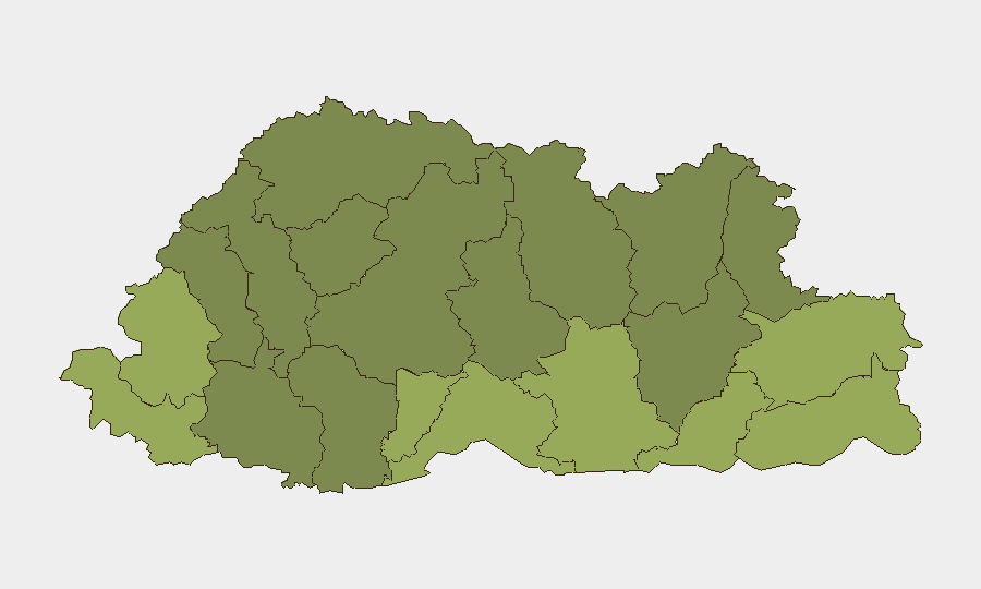
Situation Summary
Bhutan maintains a stable security environment with no confirmed incidents of civil unrest, conflict, or infrastructure disruption reported in the last 24–48 hours. The composite national threat score remains low (7/100), consistent with Bhutan's historical trajectory as one of South Asia's most stable states. Four tracked events across religion, community, and bilateral business sentiment are under monitoring but have not escalated to security-relevant incidents. The security picture is expected to remain steady absent new developments.
Key Developments
No specific, corroborated security incidents meeting duty-of-care relevance have been reported in Bhutan in the last 24–48 hours. Open-source reporting across Bhutanese government media, regional South Asian security feeds, and major international news outlets contains no reports of protests, detentions with security implications, terrorist activity, curfews, or infrastructure failures in that window. Four event signals flagged by GeoBit—including a 23 June religion-related investigation and a community-level arrest—remain under review; public reporting does not yet provide sufficient detail to confirm operational risk. Major foreign ministries have issued no new travel advisories or threat-level changes for Bhutan. Routine security caution remains standard; situational changes will be flagged if confirmed.
Highest-Risk Areas
Samtse, Sarpang, and Haa districts (risk scores 58, 55, and 52 respectively) account for the majority of sub-national threat concentration and warrant priority monitoring for corporate and NGO footprints. All three border sensitive zones—Samtse and Sarpang adjoin India; Haa borders China—and historical cross-border activity patterns, including intermittent encroachment tensions and trade-route security, elevate their composite risk profiles. Samdrup Jongkhar, Pemagatshel, and Tsirang districts follow as secondary concern areas. Central and northern districts (Lhuntse, Gasa, Lhuntse) carry materially lower risk but remain subject to seasonal access constraints and limited emergency response infrastructure.
How GeoBit Would Assist
Security teams with personnel or assets in Bhutan should deploy AOI Monitoring & Early Warning on Samtse, Sarpang, and Haa districts, paired with multi-language OSINT and social-media intelligence (X, Telegram, local forums) to detect protest activity, administrative actions, or cross-border incidents before mainstream reporting. Conflict & Military tracking, border & disputed-territory search, and satellite imagery analysis of sensitive zones provide early signals of encroachment or security force repositioning. Routing & Network Analysis supports contingency planning for personnel evacuation or asset relocation if district-level risk escalates.
7-Day Outlook
No acute security triggers are visible on the near-term horizon. Seasonal monsoon conditions (June–August) may affect road access in northern and eastern districts but pose no direct security risk. Monitoring of the four tracked events will continue; if any escalate to confirmed unrest, detention of foreign nationals, or infrastructure impact, alert protocols will activate immediately.
Highest-Risk Areas — Ranked
| # | State / Region | Risk |
|---|---|---|
| 1 | Samtse District | 58 |
| 2 | Sarpang District | 55 |
| 3 | Haa District | 52 |
| 4 | Pemagatshel District | 50 |
| 5 | Samdrup Jongkhar District | 48 |
| 6 | Tsirang District | 45 |
| 7 | Zhemgang District | 42 |
| 8 | Trashigang District | 40 |
| 9 | Mongar District | 38 |
| 10 | Gasa District | 35 |
| 11 | Lhuntse District | 32 |
| 12 | Wangdue Phodrang District | 30 |
Previous Daily Briefs
A new Bhutan brief is written every day — each with its own risk map and downloadable CSV. Here's the last week; use the calendar to go further back.
📅 Browse every day by calendar →
Highlighted days have a brief. Tap a day for that day's map & analysis, or “csv” for that day's dataset ($5).