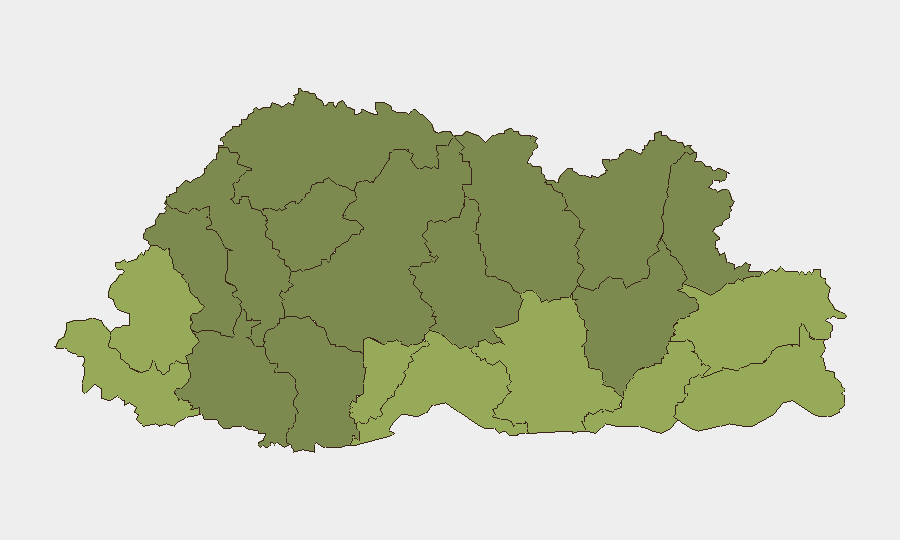
Situation Summary
Bhutan remains a low-threat environment (global rank #185, composite score 4) with no confirmed security events recorded during the reporting week. The country continues to benefit from stable governance, low crime rates, and strong border management protocols. However, environmental hazards—particularly glacial lake outburst flood (GLOF) risk in high-altitude regions—constitute an emerging operational concern requiring heightened monitoring and contingency planning.
Key Developments
- Bhutan (national)—October 13, 2026: Bhutanese authorities identified 17 potentially dangerous glacial lakes and issued warnings of elevated GLOF probability comparable to recent catastrophic flooding in Uttarakhand (India). The assessment underscores climate-driven hydrological risk in border and high-altitude zones; further operational detail and affected district specificity remain unavailable in open sources.
- Thimphu—October 10, 2026 (publication; meeting date discrepancy noted): India and Bhutan held bilateral security discussions addressing border management, mobile-signal spillover, integrated check posts, boundary-pillar maintenance, and police capacity-building. The meeting reflects ongoing coordination on transnational operational issues; no incidents or tensions were reported.
Highest-Risk Areas
Southern border districts—Samtse (risk 58), Sarpang (55), and Haa (52)—drive the national risk ranking, reflecting historical cross-border movement patterns, geographic permeability, and infrastructure concentration. Southeastern districts including Pemagatshel (50), Samdrup Jongkhar (48), and Tsirang (45) sustain elevated composite scores, likely linked to remote terrain, limited state presence, and historical smuggling corridors. Northern high-altitude regions (Gasa, Lhuntste, Wangdue Phodrang) rank lower but now warrant consideration of GLOF and avalanche hazards given the October 13 glacial-lake warning. Risk concentration in border zones reflects Bhutan's geographic position and existing security architecture.
How GeoBit Would Assist
Security and duty-of-care teams operating in Bhutan should deploy AOI Monitoring & Early Warning to track southern border districts and high-altitude zones for emerging incidents, cross-border movement anomalies, and environmental hazards; combine this with Satellite & Imagery Analysis to assess GLOF risk in identified glacial-lake clusters and infrastructure vulnerability. Intel Sweep (global event feeds, multi-language OSINT, entity extraction) provides real-time corroboration of official alerts and cross-border developments, while Risk & Threat Assessment and Environmental & Health data models contextualize seasonal and climate-driven hazards. Routing & Network Analysis supports contingency planning and identification of alternative supply/evacuation corridors in high-risk southern districts.
7-Day Outlook
No acute security deterioration is anticipated in the near term; Bhutan's political and institutional stability remains robust. Environmental monitoring—particularly GLOF early-warning systems and monsoon-season infrastructure assessments—should dominate operational planning through Q4 2026. Routine border-management coordination between Bhutan and India is expected to continue; any material shifts in regional stability or cross-border incidents will be captured in subsequent reporting cycles.
Highest-Risk Areas — Ranked
| # | State / Region | Risk |
|---|---|---|
| 1 | Samtse District | 58 |
| 2 | Sarpang District | 55 |
| 3 | Haa District | 52 |
| 4 | Pemagatshel District | 50 |
| 5 | Samdrup Jongkhar District | 48 |
| 6 | Tsirang District | 45 |
| 7 | Zhemgang District | 42 |
| 8 | Trashigang District | 40 |
| 9 | Mongar District | 38 |
| 10 | Gasa District | 35 |
| 11 | Lhuntse District | 32 |
| 12 | Wangdue Phodrang District | 30 |
Sources
Previous Weekly Briefs
A new Bhutan brief is written every Monday, covering the week — each with its own risk map and downloadable CSV. Use the calendar to go further back.
- October 6, 2026
- September 29, 2026
- September 22, 2026
- September 15, 2026
- September 8, 2026
- September 1, 2026
- August 29, 2026
📅 Browse past briefs by calendar →
Highlighted days have a brief. Tap a day for that day's map & analysis, or “csv” for that day's dataset ($5).
Atlas — our AI intelligence desk — emails them this snapshot personally. Nothing else, no list.