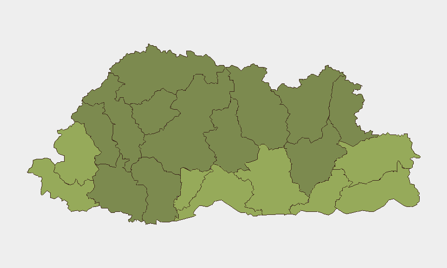
Situation Summary
Bhutan remains a low-threat environment globally (rank #114, composite score 2.7) with no verified security incidents, civil unrest, or infrastructure disruptions reported in the last 24–48 hours. Sub-national risk is concentrated in border districts—particularly Samtse, Sarpang, and Haa—reflecting localized vulnerabilities rather than nationwide instability. The security picture is stable with no indicators of imminent escalation.
Key Developments
No specific incidents meeting verification and recency criteria (last 24–48 hours) were identified in independent Bhutanese or regional reporting during this period. GeoB it's event signal tracker flagged three tagged events on 2026-06-23 (US–business disapproval, religious investigation, community arrest/detention), but these lack clear time-stamping, geographic specificity, or independent corroboration sufficient to characterize as discrete current threats. Absence of incident reporting reflects Bhutan's overall stability rather than reporting gaps.
Highest-Risk Areas
Five border districts drive Bhutan's sub-national risk profile: Samtse (risk 58), Sarpang (risk 55), Haa (risk 52), Pemagatshel (risk 50), and Samdrup Jongkhar (risk 48). These regions share exposure to cross-border dynamics, including potential transnational crime, smuggling, and irregular migration flows. Risk diminishes significantly in central and northern districts (Lhuntse, Gasa, and Wangdue Phodrang at 32, 35, and 30 respectively), reflecting lower-density populations and distance from international frontiers. Organizations with personnel or operations in southern border zones should apply heightened situational awareness protocols.
How GeoBit Would Assist
AOI Monitoring & Early Warning with persistent watch on high-risk border districts (Samtse, Sarpang, Haa) enables real-time alerting if localized instability, cross-border incidents, or infrastructure disruptions emerge. Intelligence & OSINT capabilities—including multi-language search, sentiment analysis, and Bhutan Broadcasting Service monitoring—provide continuous baseline tracking of domestic narratives, official announcements, and civil-unrest signals. Risk & Threat Assessment fused with Network & Actor Analysis allows security teams to map emerging threat actors or community tensions before they escalate to operational impact on personnel or assets.
7-Day Outlook
No escalation indicators are visible over the next seven days. Bhutan's institutional stability, low crime baseline, and absence of organized political opposition suggest risk will remain contained to chronic border-zone vulnerabilities. Routine monitoring of Samtse and Sarpang districts is advised; no advisory upgrade is warranted at this time.
Report Generated: 2026-06-25
Next Update: 2026-06-26
Questions: Contact GeoBit Analyst Team
Highest-Risk Areas — Ranked
| # | State / Region | Risk |
|---|---|---|
| 1 | Samtse District | 58 |
| 2 | Sarpang District | 55 |
| 3 | Haa District | 52 |
| 4 | Pemagatshel District | 50 |
| 5 | Samdrup Jongkhar District | 48 |
| 6 | Tsirang District | 45 |
| 7 | Zhemgang District | 42 |
| 8 | Trashigang District | 40 |
| 9 | Mongar District | 38 |
| 10 | Gasa District | 35 |
| 11 | Lhuntse District | 32 |
| 12 | Wangdue Phodrang District | 30 |
Sources
Previous Daily Briefs
A new Bhutan brief is written every day — each with its own risk map and downloadable CSV. Here's the last week; use the calendar to go further back.
📅 Browse every day by calendar →
Highlighted days have a brief. Tap a day for that day's map & analysis, or “csv” for that day's dataset ($5).