Situation Summary
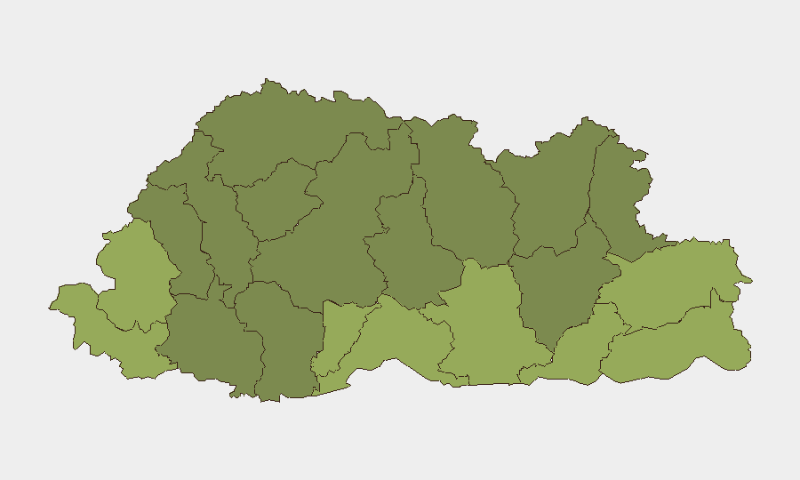
Bhutan remains a low-threat environment globally (rank #183, composite score 3) with minimal organized security incidents. Two tracked events have been flagged in the platform as of 13 July 2026, though corroborating detail from independent sources has not yet been confirmed. The southern border districts—Samtse, Sarpang, Haa, and Pemagatshel—carry elevated composite risk scores (50–58) relative to the rest of the country, likely reflecting cross-border exposure and terrain factors rather than active conflict.
Key Developments
Current 24–48-hour event signals cannot be reliably attributed to specific incidents without independent confirmation. The GeoBit platform has registered three event signals dated 11–13 July (one public statement, one community-related investigation, one disapproval statement), all tagged to Bhutan, but available open-source reporting does not yet corroborate the underlying details, locations, or operational significance. Until corroborating reporting is available, these signals should be treated as alerts pending verification rather than confirmed incidents. Corporate security teams with personnel or assets in Bhutan are advised to request additional OSINT depth on these three signals if operational decisions hinge on them.
Highest-Risk Areas
Samtse, Sarpang, Haa, and Pemagatshel districts represent the highest composite risk tier (50–58), all located in southern Bhutan along the Indian border. Risk concentration in these districts reflects proximity to cross-border movement, terrain vulnerability, and population density patterns rather than presently active armed conflict. The remaining eight tracked districts (Samdrup Jongkhar through Wangdue Phodrang) show lower but measurable risk scores (30–48), with mountain and eastern regions (Lhuntse, Gasa) at the lower end of the scale. For corporate operations, southern border zones warrant enhanced situational awareness protocols; central and northern regions present lower baseline threat.
How GeoBit Would Assist
GeoBit's AOI Monitoring & Early Warning capability would enable persistent watch on Samtse, Sarpang, and Haa districts with real-time alerting tied to X/Telegram OSINT, local news feeds, and cross-border movement signals. Intel Sweep and OSINT fusion would corroborate and contextualize the three pending 11–13 July signals, establishing whether they represent localized community incidents, border activity, or administrative actions with operational relevance to corporate duty of care. GIS & Spatial Analysis and alternative route/journey planning support can help security teams model safe transit corridors and identify real-time detours around elevated-risk zones for personnel movement.
7-Day Outlook
No specific incident escalation is forecasted for the next seven days based on current signal density and global Bhutan threat trajectory. Seasonal monsoon conditions and cross-border labor migration may generate routine administrative activity in southern districts; these should not be automatically conflated with security deterioration. Recommended posture: maintain standard corporate security protocols, monitor the three pending signals through GeoBit and news feeds, and activate enhanced briefing if any independent reporting validates operational impact to corporate presence.
Highest-Risk Areas — Ranked
| # | State / Region | Risk |
|---|---|---|
| 1 | Samtse District | 58 |
| 2 | Sarpang District | 55 |
| 3 | Haa District | 52 |
| 4 | Pemagatshel District | 50 |
| 5 | Samdrup Jongkhar District | 48 |
| 6 | Tsirang District | 45 |
| 7 | Zhemgang District | 42 |
| 8 | Trashigang District | 40 |
| 9 | Mongar District | 38 |
| 10 | Gasa District | 35 |
| 11 | Lhuntse District | 32 |
| 12 | Wangdue Phodrang District | 30 |
Sources
Previous Daily Briefs
A new Bhutan brief is written every day — each with its own risk map and downloadable CSV. Here's the last week; use the calendar to go further back.
📅 Browse every day by calendar →
Highlighted days have a brief. Tap a day for that day's map & analysis, or “csv” for that day's dataset ($5).
Atlas — our AI intelligence desk — emails them this snapshot personally. Nothing else, no list.