Situation Summary
East Timor remains in a stable security baseline with no confirmed acute incidents reported in the past 24–48 hours. However, an urgent presidential meeting convened on 19 June by President José Ramos-Horta with government and UN/development partners signals active attention to unspecified national issues. Sub-national risk remains concentrated in Dili and western districts (Liquiçá, Baucau), though the absence of discrete event reporting in the current window suggests no imminent escalation is evident to open sources.
Key Developments
- Dili – 19 June 2026 – Presidential emergency coordination meeting: President Ramos-Horta convened an urgent meeting with government ministers and representatives of UN agencies and development partners. The official presidency read-out does not disclose specific triggering incidents (violence, infrastructure failure, or unrest), leaving the exact subject matter unclear from available open sources.
- No confirmed security incidents nationwide (last 48 hours): Cross-check of international news wires, regional outlets, and social media detected no verified reports of civil unrest, armed clashes, significant crime, infrastructure disruption, or political shocks with reliable time-stamps within the reporting window.
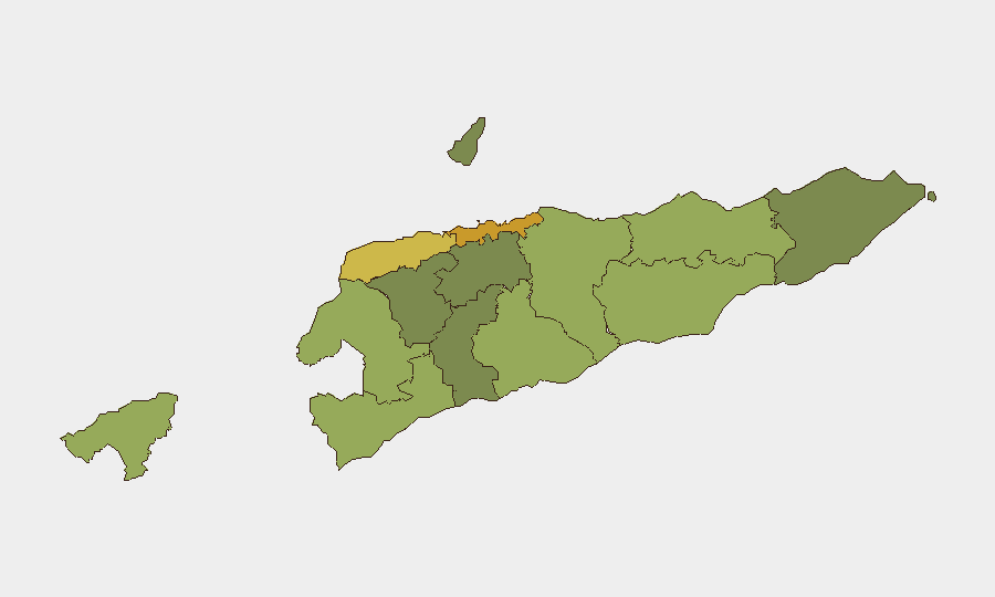
- Dili risk profile elevated in baseline assessment: Dili continues to rank as the highest-risk district (score 72) in GeoBit's sub-national model, consistent with its role as the capital and densest urban center; no new localized triggers have emerged in recent reporting.
- Western maritime/border zone remains secondary focus: Liquiçá (risk 62) and Baucau (risk 58) remain the second and third highest-risk districts, reflecting historical patterns of inter-community tensions and border-adjacent dynamics, though no acute incidents are reported in the current window.
- Monitoring posture heightened pending clarification: The absence of a detailed presidential statement on the 19 June meeting creates an information gap; corporate teams with personnel in Dili should remain alert to official statements or subsidiary reporting that may clarify the meeting's subject and any follow-on directives.
Highest-Risk Areas
Dili dominates risk exposure (score 72), reflecting concentration of government, commercial, and international presence in a capital where densely packed informal settlements, inter-community friction, and occasional gang activity create a persistently elevated baseline. The western crescent—Liquiçá and Baucau—registers the second and third highest risks, driven by historical border tensions with Indonesia, periodic communal disputes, and weaker state presence. Cova Lima (score 55) and Bobonaro (score 53) add incremental risk in the southwest; eastern and southern districts (Manatuto, Ainaro, Ermera, Aileu) register lower baseline scores and are generally assessed as lower-priority areas for corporate security planning.
How GeoBit Would Assist
Security and duty-of-care teams should deploy AOI Monitoring & Early Warning on Dili's CBD and main residential/commercial clusters, paired with X/Twitter & Telegram OSINT and multi-language search to detect emerging protest activity, security force mobilization, or incident chatter before mainstream reporting surfaces. Routing & Network Analysis can identify alternative transit routes and safe zones should mobility in Dili become constrained. A structured watchlist covering Dili-based local media, UN agency situation reports, and historical protest flashpoints will provide real-time trending on the government's current priorities and any subsequent incidents.
7-Day Outlook
No imminent escalation is signaled by available evidence; the presidential meeting suggests active governance response rather than crisis management. Risk trajectory over the next week remains dependent on the clarification and follow-on actions emerging from the 19 June meeting; teams should monitor official statements and UN/diplomatic reporting for guidance on whether this was a routine coordination session or response to a developing issue. Standard vigilance posture in Dili and western districts is warranted.
Highest-Risk Areas — Ranked
| # | State / Region | Risk |
|---|---|---|
| 1 | Dili | 72 |
| 2 | Liquiçá | 62 |
| 3 | Baucau | 58 |
| 4 | Cova Lima | 55 |
| 5 | Bobonaro | 53 |
| 6 | Oecussi-Ambeno | 48 |
| 7 | Manufahi | 45 |
| 8 | Viqueque | 42 |
| 9 | Manatuto | 40 |
| 10 | Ainaro | 38 |
| 11 | Ermera | 36 |
| 12 | Aileu | 32 |
Sources
Previous Daily Briefs
A new East Timor brief is written every day — each with its own risk map and downloadable CSV. Here's the last week; use the calendar to go further back.
📅 Browse every day by calendar →
Highlighted days have a brief. Tap a day for that day's map & analysis, or “csv” for that day's dataset ($5).