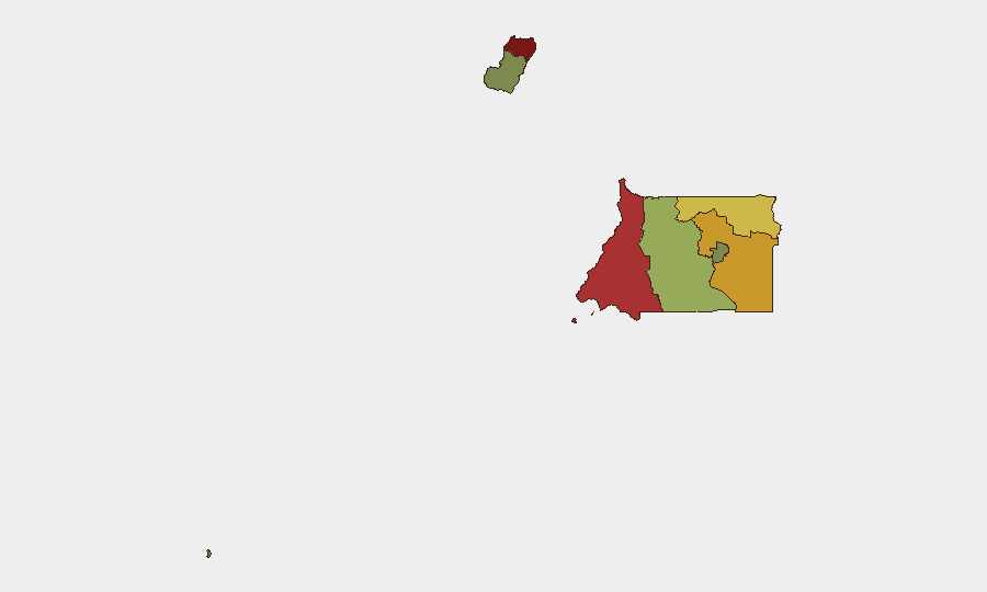
Situation Summary
Equatorial Guinea presents a low-frequency, structurally elevated security environment with no acute incidents reported in the last 24–48 hours. The country ranks #164 globally on composite threat metrics; however, significant sub-national variance persists, with Bioko Norte and Litoral Province carrying substantially higher risk profiles than southern and island regions. The security picture reflects persistent baseline vulnerabilities—organized crime, trafficking networks, and governance constraints—rather than active conflict or destabilization trajectories.
Key Developments
No discrete security, crime, civil unrest, infrastructure, or travel-risk incidents with confirmed date, location, and detail were reported in Equatorial Guinea during July 6–7, 2026. Open-source monitoring across news, social media, and web sources yielded no corroborated event reports meeting incident-level criteria for this 48-hour window.
Highest-Risk Areas
Bioko Norte (risk score 85) and Litoral Province (risk 78) dominate the sub-national risk landscape, together accounting for the majority of structural vulnerability. Bioko Norte's elevated score reflects port and maritime trafficking exposure, as well as cross-border facilitation vectors; Litoral Province compounds this with active smuggling corridors and limited law-enforcement capacity in remote border zones. Wele-Nzas Province (72) extends the northern risk belt, driven by porous frontier controls and criminal network presence. By contrast, Djibloho (15) and Annobón Province (8) present minimal acute risk, reflecting lower population density, reduced criminal infrastructure, and geographic isolation.
How GeoBit Would Assist
Security teams operating in Equatorial Guinea should employ AOI Monitoring & Early Warning on Bioko Norte and Litoral Province to detect trafficking activity, port disruptions, or cross-border incidents in real time. OSINT fusion across local media, Telegram, and X/Twitter would provide multi-language detection of emerging crime spikes, civil unrest, or regime-stability shifts before they escalate. Routing & Network Analysis supports duty-of-care teams in planning secure travel corridors and identifying trafficking checkpoints or bandit-prone transit zones, particularly in Wele-Nzas and Kié-Ntem border regions.
7-Day Outlook
No imminent acute security shock is signaled by current reporting or baseline patterns. Persistent structural risks—maritime smuggling, border criminality, and governance gaps—will continue to elevate Bioko Norte and northern provinces; monitoring for incremental escalation in trafficking activity or transnational crime coordination remains the primary forward indicator. Corporate and NGO teams should maintain standard duty-of-care protocols and area-specific contingency planning without elevated immediate alert posture.
Highest-Risk Areas — Ranked
| # | State / Region | Risk |
|---|---|---|
| 1 | Bioko Norte | 85 |
| 2 | Litoral Province | 78 |
| 3 | Wele-Nzas Province | 72 |
| 4 | Kié-Ntem Province | 68 |
| 5 | Centro Sur Province | 45 |
| 6 | Bioko Sur | 38 |
| 7 | Djibloho | 15 |
| 8 | Annobón Province | 8 |
Sources
Previous Daily Briefs
A new Equatorial Guinea brief is written every day — each with its own risk map and downloadable CSV. Here's the last week; use the calendar to go further back.
📅 Browse every day by calendar →
Highlighted days have a brief. Tap a day for that day's map & analysis, or “csv” for that day's dataset ($5).
Atlas — our AI intelligence desk — emails them this snapshot personally. Nothing else, no list.