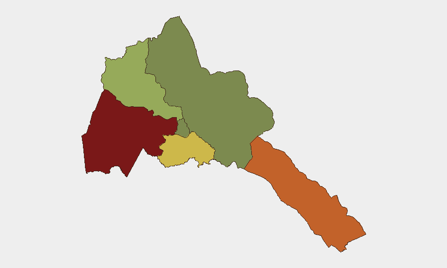
Situation Summary
Eritrea remains a low-frequency threat environment (global rank #80; composite score 24) with no discrete security incidents recorded inside the country during the past week. However, the October 1–2 diplomatic rupture between Eritrea and Ethiopia, coupled with allegations of Eritrean military involvement in Ethiopia's renewed Tigray conflict, has materially elevated regional escalation and spillover risk. The severing of diplomatic relations and closure of embassy channels removes a key conflict-containment mechanism and signals potential direct Eritrean participation in Ethiopian internal fighting. The immediate threat to Eritrea itself remains contained to its border zones and Red Sea access points; however, the trajectory is towards heightened interstate tension and potential cross-border military activity.
Key Developments
- Asmara, October 1: Eritrea severed diplomatic relations with Ethiopia after Ethiopia's government closed Eritrea's embassy in Addis Ababa, expelled 10 Eritrean diplomats, and accused Eritrea of hostile activity linked to renewed fighting in northern Ethiopia. Eritrea's Ministry of Information confirmed the reciprocal diplomatic break.
- Asmara–Ethiopia diplomatic missions, October 1–2: The collapse of bilateral diplomatic channels eliminated a key communication pathway during active conflict. The African Union issued a restraint appeal, underscoring concern over the loss of direct negotiation channels.
- Afar Region, Ethiopia–Eritrea border, October 1: Ethiopia's Afar governor alleged direct Eritrean military participation in ongoing fighting and claimed Eritrean forces were attempting to sever the strategic Djibouti–Eritrea transport corridor. Eritrea has not publicly responded to these allegations, and independent verification remains unavailable.
- Eritrea Red Sea coastline, October 1–2: Regional analysts assessed that Eritrea may be providing Red Sea access to forces involved in Ethiopia's conflict, increasing risk of fighting spillover into Eritrean territory and disruption to Horn of Africa maritime routes. No independent confirmation of new military activity inside Eritrea was documented.
- Eritrea–Ethiopia–Sudan border area, October 2: Security analysts flagged the diplomatic collapse and alleged Eritrean military involvement as a significant escalation vector, with potential for conflict expansion into Eritrea and Sudan. No active ground engagement inside Eritrea was reported during the week.
Highest-Risk Areas
Gash-Barka (score 92) and Southern Red Sea Region (score 75) dominate Eritrea's sub-national risk profile, both directly adjacent to the Ethiopia border and zones of alleged military activity. Gash-Barka's elevated score reflects its proximity to renewed Tigray fighting and cross-border military claims; Southern Red Sea faces risk from both alleged Eritrean military involvement in Ethiopian operations and potential retaliatory activity. Debub Region (score 68) presents secondary risk from border instability, while Maekel Region (score 18) and Northern Red Sea Region (score 0) remain substantially lower-risk. Organizations with personnel or assets in Gash-Barka and Southern Red Sea should heighten monitoring of cross-border movement and diplomatic developments.
How GeoBit Would Assist
Security teams should employ AOI Monitoring & Early Warning focused on Gash-Barka and Southern Red Sea border zones to detect cross-border military movement or infrastructure disruption. Conflict & Military capabilities (battle mapping, force structure tracking) combined with Network & Actor Analysis and regional OSINT (social media, local reporting, radio SIGINT) would provide real-time visibility into Eritrean military posture and alleged Ethiopian operations. Routing & Network Analysis supports contingency planning for alternative supply and personnel movement routes if the Djibouti–Eritrea corridor or other transport nodes are disrupted.
7-Day Outlook
The diplomatic rupture is likely to harden over the near term absent direct African Union mediation. Risk of cross-border incursion or Eritrean military escalation in border zones remains elevated, particularly if Ethiopia's Tigray offensive expands. Organizations should maintain heightened alert posture for travel disruptions, asset access limitations, and potential regional destabilization through mid-October.
Highest-Risk Areas — Ranked
| # | State / Region | Risk |
|---|---|---|
| 1 | Gash-Barka | 92 |
| 2 | Southern Red Sea Region | 75 |
| 3 | Debub Region | 68 |
| 4 | Anseba | 55 |
| 5 | Maekel Region | 18 |
| 6 | Northen Red Sea Region | 0 |
Sources
Previous Weekly Briefs
A new Eritrea brief is written every Monday, covering the week — each with its own risk map and downloadable CSV. Use the calendar to go further back.
- September 29, 2026
- September 22, 2026
- September 15, 2026
- September 8, 2026
- September 2, 2026
- August 31, 2026
- August 29, 2026
📅 Browse past briefs by calendar →
Highlighted days have a brief. Tap a day for that day's map & analysis, or “csv” for that day's dataset ($5).
Atlas — our AI intelligence desk — emails them this snapshot personally. Nothing else, no list.