Situation Summary
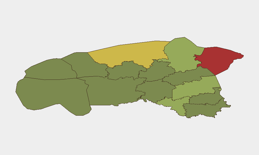
Estonia remains a low-threat environment globally (composite score 6/100), with no active security incidents tracked in the current reporting window. The nation's security posture is stable; recent state activity reflects routine defense modernization and scheduled commemorative events rather than emerging instability. However, sub-national risk concentration in northeastern counties—particularly Ida-Viru (78) and Harju (68)—warrants continuous monitoring by organizations operating in those zones.
Key Developments
- Rapla, 2026-06-23: Estonia held its Victory Day parade with approximately 1,000 personnel. This was a planned commemorative event with no reported security disruptions.
- Tallinn, 2026-06-23: Estonia's foreign minister issued Victory Day messaging on X reaffirming national sovereignty themes. Standard political communications; no incident component.
- Nationwide rail network, 2026-06-23: Eesti Raudtee and Elron conducted a joint drone-emergency drill, testing train stoppage and passenger protection procedures. This represents preparedness activity and confirms infrastructure resilience planning rather than operational disruption.
- Estonia (national), 2026-06-23: Estonia received delivery of its first IRIS-T SLM air-defense system. This reflects ongoing NATO-aligned defense capability enhancement; no threat event.
- No discrete crime, civil unrest, infrastructure failure, or travel-safety incidents confirmed in the last 24–48 hours across available open-source channels.
Highest-Risk Areas
Ida-Viru and Harju counties dominate the risk profile, together accounting for the majority of Estonia's sub-national threat concentration. Ida-Viru's elevated risk (78) reflects its proximity to the Russian border, historical industrial-era infrastructure vulnerabilities, and ongoing cyber-targeting of critical systems in the region. Harju (68), which encompasses Tallinn and the nation's primary economic and governmental hub, carries risk tied to its role as a digital-services and administrative center, making it a persistent focus for nation-state and cybercriminal reconnaissance. Tartu County (58) and Valga County (55) show elevated risk, likely reflecting secondary concentration near borders and transport corridors. Southern and western counties show substantially lower risk profiles.
How GeoBit Would Assist
Organizations with personnel or assets in Ida-Viru and Harju should deploy AOI (Area-of-Interest) Monitoring & Early Warning on critical facilities and transport nodes to detect emerging incidents in real time. Intel Sweep and multi-source OSINT (X/Twitter, Telegram, local news feeds, and radio SIGINT) will surface early indicators of cyber campaigns, civil unrest, or infrastructure disruption before they escalate. For cross-border or sensitive supply-chain operations, Routing & Network Analysis can identify alternative transport and communication paths to mitigate exposure to high-risk corridors.
7-Day Outlook
No material deterioration in Estonia's security environment is anticipated over the next seven days. Planned state activities (defense drills, NATO exercises, and infrastructure testing) will continue. Persistent baseline risks—cyber reconnaissance on critical infrastructure, border-zone monitoring, and supply-chain vulnerabilities in the northeast—remain unchanged and should be assumed as constant operational background.
Highest-Risk Areas — Ranked
| # | State / Region | Risk |
|---|---|---|
| 1 | Ida-Viru County | 78 |
| 2 | Harju County | 68 |
| 3 | Tartu County | 58 |
| 4 | Valga County | 55 |
| 5 | Lääne-Viru County | 52 |
| 6 | Pärnu County | 35 |
| 7 | Rapla County | 32 |
| 8 | Jõgeva County | 30 |
| 9 | Järva County | 28 |
| 10 | Viljandi County | 25 |
| 11 | Põlva County | 22 |
| 12 | Võru County | 18 |
Sources
Previous Daily Briefs
A new Estonia brief is written every day — each with its own risk map and downloadable CSV. Here's the last week; use the calendar to go further back.
📅 Browse every day by calendar →
Highlighted days have a brief. Tap a day for that day's map & analysis, or “csv” for that day's dataset ($5).