Situation Summary
Finland's security environment remains stable and low-risk as of 5 August 2026, with composite threat score of 6 globally and no active civil unrest, major crime incidents, or infrastructure disruption. A precautionary air and maritime traffic restriction in the eastern Gulf of Finland early on 4 August was lifted within two hours after no drone incursions materialized. The country presents routine operational conditions for corporate presence and asset management.
Key Developments
- Eastern Gulf of Finland – 4 August 0526–0713 hrs: Finnish Defence Forces implemented a temporary precautionary restriction on air traffic (beginning 0526 hrs) and maritime traffic (0540 hrs) in response to potential drone activity; restrictions were lifted at 0713 hrs with no confirmed airspace or territorial violations.[5]
- Nationwide – 4–5 August: Open-source monitoring across news outlets and social media detected no corroborated reports of civil unrest, protest activity, major crime spikes, or infrastructure failures meeting analytical thresholds; operational environment remains calm.[2]
- No discrete security events in the current 24–48-hour window beyond the precautionary maritime/air restriction; no terrorism, organized-crime, or regime-stability indicators present in recent reporting.
Highest-Risk Areas
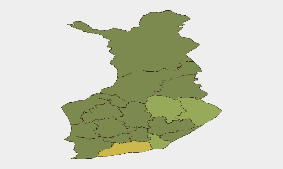
Uusimaa (composite risk 65) dominates Finland's sub-national risk profile, reflecting its status as the capital region and administrative, economic, and demographic center; North Karelia (44) and Kymenlaakso (42) follow, likely reflecting proximity to the Russian border and historical cross-border crime patterns. The eastern and south-eastern regions (North Karelia, South Karelia, North Savo, Kymenlaakso) collectively account for elevated risk scores consistent with border-adjacent vulnerabilities, though no acute incidents are currently active. Risk concentration in Uusimaa remains typical for a capital region and does not indicate imminent threat elevation.
How GeoBit Would Assist
Corporate security teams with personnel or assets in Finland should deploy AOI Monitoring & Early Warning capabilities on Uusimaa and North Karelia to detect emerging civil unrest, protest activity, or infrastructure incidents in real time. OSINT fusion (news, social media, radio SIGINT) across multi-language sources would provide 24–48-hour advance warning of escalating border-related or maritime incidents. Alternative route and network analysis for supply chains or staff movement would mitigate exposure to any future traffic restrictions in border regions or Gulf of Finland approaches.
7-Day Outlook
Finland's threat posture is expected to remain low and stable over the next seven days absent new cross-border incidents or maritime anomalies. The 4 August precautionary drone response suggests heightened situational awareness by Finnish Defence Forces; similar brief traffic restrictions may recur without strategic warning. Routine duty-of-care monitoring and standard travel-safety protocols remain sufficient for corporate operations in all regions.
Highest-Risk Areas — Ranked
| # | State / Region | Risk |
|---|---|---|
| 1 | Uusimaa | 65 |
| 2 | North Karelia | 44 |
| 3 | Kymenlaakso | 42 |
| 4 | North Savo | 40 |
| 5 | South Karelia | 38 |
| 6 | Kainuu | 36 |
| 7 | Päijät-Häme | 35 |
| 8 | South Savo | 32 |
| 9 | Kanta-Häme | 30 |
| 10 | Pirkanmaa | 28 |
| 11 | Central Finland | 26 |
| 12 | Southwest Finland | 25 |
Sources
Previous Daily Briefs
A new Finland brief is written every day — each with its own risk map and downloadable CSV. Here's the last week; use the calendar to go further back.
📅 Browse every day by calendar →
Highlighted days have a brief. Tap a day for that day's map & analysis, or “csv” for that day's dataset ($5).
Atlas — our AI intelligence desk — emails them this snapshot personally. Nothing else, no list.