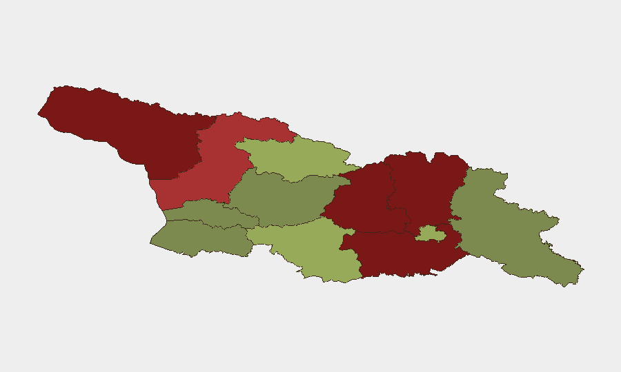
Situation Summary
Georgia remains a stable, low-incident environment with no confirmed major security, conflict, or civil-unrest events in the last 24–48 hours. All major urban centers and transport corridors are fully operational, and no ceasefire violations or hostile military activity has been reported along de facto border areas. A single unverified flood event has been flagged as a potential operational concern, but its exact location and impact remain unconfirmed and require field verification. The national composite threat score of 3 and stable 7-day outlook support routine duty-of-care protocols for corporate personnel and operations.
Key Developments
- De facto border regions (Abkhazia and South Ossetia-adjacent zones) – 12–13 June 2026: No new military activity, ceasefire violations, or hostile troop movements reported along administrative boundary lines, despite these areas retaining structurally elevated risk profiles.
- Major urban centers (Tbilisi, Batumi, Kutaisi) – 12–13 June 2026: Monitoring confirmed no active protests, demonstrations, targeted attacks, or significant civil unrest during the 48-hour window.
- Key transport corridors (Gori–Zugdidi axis, Batumi border crossings, Stepantsminda–Dariel Pass) – 12–13 June 2026: All major routes remain fully operational with no conflict-related closures, new checkpoints, or significant disruptions.
- Unspecified location, Georgia – ~12–13 June 2026: One flood event flagged by specialized monitoring; exact location, timing, and damage extent remain unverified and require field confirmation. No corroborating open-source reporting has clarified the scope or impact.
- National security posture – 14 June 2026: No significant escalation is anticipated over the next 7 days; routine corporate security measures remain appropriate.
Highest-Risk Areas
The Autonomous Republic of Abkhazia (risk 95) and the north-central regions of Shida Kartli (88) and Lower Kartli (85) drive Georgia's sub-national risk profile, driven primarily by structural proximity to de facto borders and historical conflict zones. Mtskheta-Mtianeti (82) and Samegrelo-Upper Svaneti (78) retain elevated scores linked to geographic isolation and limited state capacity in mountainous terrain. Tbilisi itself scores 45, reflecting its role as the capital and primary urban center; routine vigilance around public gatherings and transport hubs remains standard. All other regions score below 50 and present low to moderate baseline risk.
How GeoBit Would Assist
Teams with personnel or operations in Georgia should employ AOI Monitoring & Early Warning on the de facto border regions and key transport nodes to detect emerging military activity or unrest in near-real time. OSINT fusion and multi-language search across Georgian, Russian, and international sources will corroborate or clarify the unverified flood event and track secondary impacts on supply chains or travel. Routing & Network Analysis can identify alternative corridors and safe passage strategies should major routes experience unexpected disruption. Combined, these capabilities provide both strategic early warning and operational decision support for on-the-ground duty-of-care teams.
7-Day Outlook
No significant escalation is anticipated over the next 7 days. Weather and flooding remain the only identified non-security risk factor, and its impact appears localized and unverified. Standard corporate security posture—staff awareness, route planning, and local liaison—is sufficient to manage residual exposure in this stable environment.
Highest-Risk Areas — Ranked
| # | State / Region | Risk |
|---|---|---|
| 1 | Autonomous Republic of Abkhazia | 95 |
| 2 | Shida Kartli | 88 |
| 3 | Lower Kartli | 85 |
| 4 | Mtskheta-Mtianeti | 82 |
| 5 | Samegrelo-Upper Svaneti | 78 |
| 6 | Samtskhe-Javakheti | 48 |
| 7 | Tbilisi | 45 |
| 8 | Racha-Lechkhumi and Kvemo Svaneti | 42 |
| 9 | Kakheti | 38 |
| 10 | Autonomous Republic of Adjara | 35 |
| 11 | Imereti | 32 |
| 12 | Guria | 28 |
Sources
Previous Daily Briefs
A new Georgia brief is written every day — each with its own risk map and downloadable CSV. Here's the last week; use the calendar to go further back.
📅 Browse every day by calendar →
Highlighted days have a brief. Tap a day for that day's map & analysis, or “csv” for that day's dataset ($5).