Situation Summary
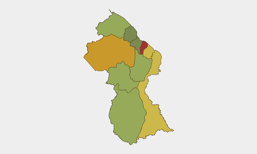
Guyana remains a low-threat environment globally (composite threat score 16), with no confirmed acute security incidents reported in the last 24–48 hours. Current diplomatic activity—notably the UN Secretary-General candidacy of Guyana's Ambassador and routine domestic outreach by senior officials—reflects normal governance operations rather than crisis response. The sub-national risk profile is concentrated in coastal regions, particularly Demerara-Mahaica and Cuyuni-Mazaruni, where organized crime, trafficking, and border-related activity drive elevated scores; interior and remote regions carry moderate baseline risk.
Key Developments
- No new security or civil-unrest incidents confirmed in Guyana within the last 24–48 hours from credible open sources or social media indexing. Coverage remains concentrated on diplomatic and domestic-policy matters.
- United Nations Headquarters, New York (18–19 June 2026): Guyana's Ambassador Carolyn Rodrigues-Birkett publicly announced candidacy for UN Secretary-General, with messaging centered on conflict prevention and international security architecture—reflective of Guyana's recent Security Council service and consistent with formal diplomatic outreach.
- Region Three, Guyana (mid-June, ongoing): Vice President Jagdeo conducted public outreach to residents addressing land allocation and service delivery; messaging frames engagement as socio-economic stabilization rather than crisis response.
- National, Social Protection Sector (mid-June): Ministry of Human Services promoted a "co-invest" initiative for child and family protection. This social-policy development has indirect implications for domestic stability but is not an active incident.
- Note on Border Context: The Guyana–Venezuela border dispute remains a persistent geopolitical backdrop; however, no escalation events are confirmed in the reporting window. Routine baseline monitoring of this area remains warranted given historical tensions.
Highest-Risk Areas
Demerara-Mahaica (risk 78) and Cuyuni-Mazaruni (risk 72) drive the national risk profile, with Mahaica-Berbice (65) and East Berbice-Corentyne (62) following. These coastal and interior regions are associated with drug-trafficking routes, organized-crime activity, and historical criminal operations; Cuyuni-Mazaruni's elevated score reflects proximity to Venezuela and remote-area governance challenges. Urban centers and mining zones within these regions concentrate personnel and asset vulnerability. The sharp drop in risk below the top four regions suggests that interior and western districts present lower immediate threat density, though they remain subject to baseline monitoring for border and remote-area incidents.
How GeoBit Would Assist
Security teams would deploy Intel Sweep and multi-language OSINT fusion to aggregate news, social media (X, Telegram), and local media feeds for real-time incident detection—particularly in Demerara-Mahaica and Cuyuni-Mazaruni, where crime and trafficking signals emerge early. Area-of-Interest Monitoring & Early Warning on these highest-risk regions, combined with border and disputed-territory search (Guyana–Venezuela), would surface escalation indicators before they mature into acute crises. For personnel movement, Routing & Network Analysis capabilities enable alternative journey planning around known crime and trafficking corridors.
7-Day Outlook
No imminent security escalation is evident. Diplomatic and domestic-policy activity will likely continue at current baseline. However, the persistent concentration of risk in coastal regions and the ongoing Guyana–Venezuela border context warrant sustained passive monitoring; any shift in regional rhetoric, military posture, or organized-crime activity could warrant rapid alert escalation. Teams with operations in Demerara-Mahaica and Cuyuni-Mazaruni should maintain current security protocols and situational awareness.
Highest-Risk Areas — Ranked
| # | State / Region | Risk |
|---|---|---|
| 1 | Demerara-Mahaica | 78 |
| 2 | Cuyuni-Mazaruni | 72 |
| 3 | Mahaica-Berbice | 65 |
| 4 | East Berbice-Corentyne | 62 |
| 5 | Upper Demerara-Berbice | 58 |
| 6 | Potaro-Siparuni | 48 |
| 7 | Barima-Waini | 45 |
| 8 | Upper Takutu-Upper Essequibo | 42 |
| 9 | Pomeroon-Supenaam | 38 |
| 10 | Essequibo Islands | 35 |
Sources
Previous Daily Briefs
A new Guyana brief is written every day — each with its own risk map and downloadable CSV. Here's the last week; use the calendar to go further back.
📅 Browse every day by calendar →
Highlighted days have a brief. Tap a day for that day's map & analysis, or “csv” for that day's dataset ($5).