Situation Summary
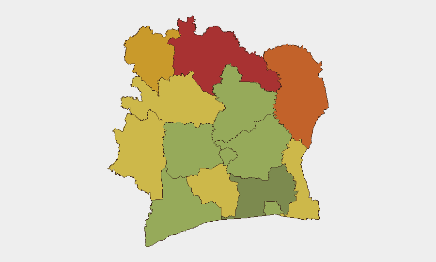
Ivory Coast remains at moderate global threat ranking (#79, composite score 15) with security conditions stable but fragmented by sub-national volatility. The most recent material security impact stems from late-June flooding in Abidjan, which caused approximately 20 deaths and ongoing infrastructure disruption; no corroborated new security incidents have surfaced in the last 24–48 hours. Northern and northeastern districts (Savanes, Zanzan, Denguélé) sustain elevated threat profiles driven by transnational crime, smuggling networks, and historical instability, while Abidjan and coastal zones face persistent crime and flood-related access risks.
Key Developments
- No corroborated new security incidents in Ivory Coast within the last 24–48 hours as of 01 August 2026. Open-source monitoring (news, social media, agency feeds) shows no verified reports of violent conflict, civil unrest, or crime surges in that window.
- Abidjan flood-impact assessment (ongoing from 27–29 June): Infrastructure damage, road closures, and search-and-rescue operations remain active in flood-affected communes (Attécoubé, Yopougon, Carrefour 09 Kilos sector). Motorist advisories remain in effect for inundated segments.
- Baseline crime and civil-unrest risk (standing advisory): Foreign travel advisories continue to flag elevated risk of violent street crime and potential unrest outside Abidjan, particularly in regions with weaker state presence. No spike reported in the last 48 hours, but risk posture remains "high caution."
- Northern district persistence (historical context): Savanes, Zanzan, and Denguélé districts maintain the highest composite threat scores (78, 75, 72 respectively), reflecting ongoing smuggling networks, cross-border movement, and limited law-enforcement capacity—conditions stable but chronic.
Highest-Risk Areas
The northern and northeastern districts—Savanes (risk 78), Zanzan (75), and Denguélé (72)—drive the majority of Ivory Coast's sub-national threat profile, primarily through transnational narcotics and arms trafficking, human smuggling, and weak state control near Mali and Burkina Faso borders. Comoé and Montagnes districts (70, 68) present secondary risk clusters linked to regional instability and criminal activity. Abidjan, while ranked lower (45), faces acute localized hazards: flood-related infrastructure failure, traffic-accident risk in damaged areas, and endemic street crime in high-density neighborhoods. Corporate assets and personnel in the capital should prioritize situational awareness around water-damaged transport corridors and crowd-gathering zones.
How GeoBit Would Assist
Security teams operating in Ivory Coast should deploy AOI (Area-of-Interest) Monitoring & Early Warning for Savanes, Zanzan, and border-crossing nodes to flag emerging trafficking activity and civil-order incidents in real time. Routing & Network Analysis can generate alternative transport corridors avoiding flood-damaged segments in Abidjan and assess safe passage through high-risk northern zones. Intel Sweep across regional news, Telegram/X channels, and local-language sources will provide 24–48-hour lead time on crime clusters, unrest, or checkpoint intensification—enabling duty-of-care teams to brief personnel and adjust movements proactively.
7-Day Outlook
Weather patterns and flood recovery are the primary near-term variables: secondary rainfall or drainage delays could re-activate access constraints in Abidjan through early August. Northern districts are expected to remain stable but under-monitored; any uptick in cross-border smuggling or security-force activity would likely surface first in regional social media and trader networks. No escalation in national-level political or civil unrest is signaled; current risk remains sub-national and crime-driven rather than conflict-driven.
Highest-Risk Areas — Ranked
| # | State / Region | Risk |
|---|---|---|
| 1 | Savanes District | 78 |
| 2 | Zanzan District | 75 |
| 3 | Denguélé District | 72 |
| 4 | Comoé District | 70 |
| 5 | Montagnes District | 68 |
| 6 | Woroba District | 65 |
| 7 | Gôh-Djiboua District | 60 |
| 8 | Sassandra-Marahoué District | 58 |
| 9 | Vallée du Bandama District | 55 |
| 10 | Bas-Sassandra District | 52 |
| 11 | Lacs District | 48 |
| 12 | Abidjan | 45 |
Sources
Previous Daily Briefs
A new Ivory Coast brief is written every day — each with its own risk map and downloadable CSV. Here's the last week; use the calendar to go further back.
📅 Browse every day by calendar →
Highlighted days have a brief. Tap a day for that day's map & analysis, or “csv” for that day's dataset ($5).
Atlas — our AI intelligence desk — emails them this snapshot personally. Nothing else, no list.