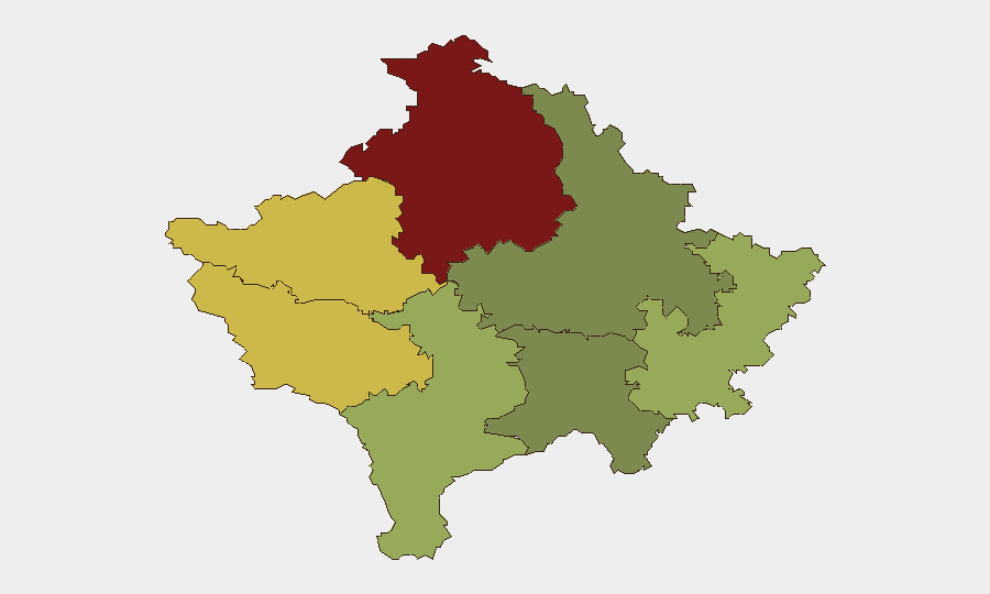
Situation Summary
Kosovo continues to face fragmented security pressures driven by widespread illegal firearms, organized property disputes, and sporadic violence against state and infrastructure workers. The national composite threat score of 11 reflects moderate overall risk, but sub-national disparities—particularly in Mitrovica district (risk 92)—indicate concentrated vulnerabilities in northern and western zones. The last 24–48 hours have seen a notable cluster of armed incidents, infrastructure attacks, and criminal enforcement operations, signaling persistent tension across multiple sectors rather than a single escalating threat.
Key Developments
- Mitrovica region, recent 24–48h: Armed attack on Regional Water Company "Mitrovica" inspection team conducting enforcement of illegal water connections; serious-crime investigation initiated by Kosovo Police.
- Multiple locations, one night (last 24–48h): Kosovo Police documented a large number of illegal firearms incidents and gunshot cases in a single night, including at least one bullet strike on a residential front door; shell seized and investigation opened. Reflects widespread illegal weapons proliferation across population.
- Peja (Peć), last 24–48h: Two men arrested after physically assaulting Kosovo Police officers who were issuing a traffic ticket; incident reported in latest police bulletin.
- Vuštrri/Vučitrn, last 24–48h: 18-year-old arrested on suspicion of starting field fire that burned large wheat-field area; arrest reported in current police update.
- Orahovac/Rahovec municipality, recent afternoon: Human remains discovered following citizen notification to police at 17:42; investigation opened into circumstances.
- Ujman area (north Kosovo), last 24–48h: Kosovo Police operation conducted to assist public company "Ibër–Lepenci" in reclaiming usurped property; ongoing land-enforcement action.
- National level, 24h police report: 79 traffic accidents with material damage, 37 with injuries, 2,763 traffic fines, 14 arrests, and 9 persons held in custody documented across Kosovo in latest 24-hour police bulletin.
Highest-Risk Areas
Mitrovica district dominates the risk landscape at score 92, driven by armed attacks on state/infrastructure workers, illegal firearms density, and ongoing property disputes—particularly in the Ujman area. Peja (68) and Gjakova (65) follow, reflecting violent resistance to law enforcement and organized criminality. In contrast, Prishtina district (28) presents significantly lower risk, making the capital and surrounding areas considerably safer for personnel and operations. Northern districts remain the primary concern for duty-of-care teams; security protocols should reflect heightened vigilance in Mitrovica and graduated caution through Peja and Gjakova.
How GeoBit Would Assist
GeoBit's AOI Monitoring & Early Warning capability enables persistent watch on highest-risk districts (Mitrovica, Peja, Gjakova) with real-time alerting on armed incidents, infrastructure attacks, and police operations affecting corporate assets. Intel Sweep and multi-language OSINT fusion track Kosovo Police bulletins, regional media, and Telegram/X crime reporting to surface emerging patterns—such as the current firearms cluster—before they escalate. Routing & Network Analysis supports journey planning and alternative-route identification for personnel transiting Mitrovica and northern zones, reducing exposure to documented incident zones.
7-Day Outlook
The clustering of firearms incidents, infrastructure attacks, and enforcement operations suggests sustained baseline tension rather than imminent major escalation. However, illegal-weapons density and armed resistance to state authority create conditions for sporadic, high-consequence incidents—particularly in Mitrovica and surrounding zones. Security teams should anticipate continued police enforcement activity and maintain heightened awareness in northern districts over the coming week.
Highest-Risk Areas — Ranked
| # | State / Region | Risk |
|---|---|---|
| 1 | District of Mitrovica | 92 |
| 2 | District of Peja | 68 |
| 3 | District of Gjakova | 65 |
| 4 | District of Prizren | 55 |
| 5 | District of Gjilan | 52 |
| 6 | District of Ferizaj | 38 |
| 7 | District of Prishtina | 28 |
Sources
Previous Daily Briefs
A new Kosovo brief is written every day — each with its own risk map and downloadable CSV. Here's the last week; use the calendar to go further back.
📅 Browse every day by calendar →
Highlighted days have a brief. Tap a day for that day's map & analysis, or “csv” for that day's dataset ($5).
Atlas — our AI intelligence desk — emails them this snapshot personally. Nothing else, no list.