Situation Summary
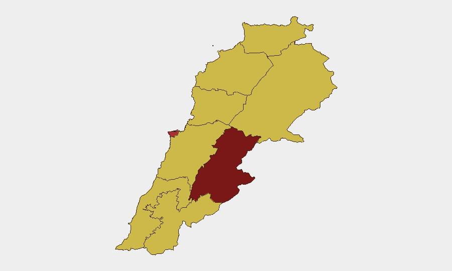
Lebanon remains under sustained military pressure along its southern border, with Israeli airstrikes and cross-border exchanges continuing despite a formal ceasefire framework. The Beqaa Governorate dominates the national threat profile (risk 90.8), while southern border zones experience active displacement, unexploded ordnance hazards, and enforced no-return zones extending 8–12 km into Lebanese territory. Regional actors—Iran, Yemen, and Israel—are signaling competing commitments to the ceasefire, creating uncertainty about escalation risk and the durability of current security assumptions.
Key Developments
- Southern Lebanon (South & Nabatieh Governorates), 16–17 June – Israeli airstrikes killed at least four people on 16 June, targeting Hezbollah launcher positions after rocket fire toward IDF forces; Lebanese Army issued standing advisories against civilian return to border villages due to sustained IDF operations in declared buffer zones.
- Southern border villages (8–12 km buffer zone), 16–17 June – Israeli "no-return" orders remain actively enforced across dozens of communities, with residents barred via social media from crossing designated lines; humanitarian monitors report ongoing mass displacement and heightened travel-restriction risk.
- Cross-border military posture (general front line), 15–17 June – Israeli air and ground operations and cross-border projectile/drone exchanges between Israeli forces and Hezbollah persisted without de-escalation indicators; risk of further escalation and civilian infrastructure impact assessed as elevated.
- Unexploded ordnance and civilian safety (South Lebanon), 16–17 June – Lebanese authorities and international monitors warned of structural damage and ordnance hazards in areas where some families have begun cautiously returning, heightening movement and travel risk in these zones.
- National political posture (Lebanon-wide), 16 June – Presidential and official statements signaled active engagement on security responses; concurrent Iranian and Yemeni messaging pressured or threatened around the southern front, increasing political instability and regional escalation uncertainty.
- Iran–Israel ceasefire signaling (regional), 16–17 June – Iranian military and political messaging warned Israel against continued southern Lebanon operations, framed recent strikes as ceasefire violations, and threatened "strong response" if attacks persist—undermining confidence in the US-Iran framework anchoring current security assumptions.
- Israeli force posture (southern Lebanon), ongoing through 17 June – Intelligence monitoring indicates Israeli forces continue preparing for prolonged presence in parts of southern Lebanon; Hezbollah maintains attack patterns on Israeli positions, sustaining high travel risk near border regions.
Highest-Risk Areas
Beqaa Governorate (90.8) and Beirut Governorate (79.7) drive Lebanon's composite threat score, reflecting military strike capability and political instability affecting the capital. Southern border governorates—South, Nabatieh, and South Lebanon's interface with Israeli buffer zones—experience the most acute acute displacement, ordnance, and cross-border exchange hazards. Mount Lebanon, North, Akkar, and Keserwan-Jbeil each carry elevated risk (60.8–60.9) tied to spillover from southern operations and regional political volatility.
How GeoBit Would Assist
Security teams would employ AOI Monitoring & Early Warning to track real-time movement, ordnance risk, and displacement patterns in South and Beqaa governorates; Conflict & Military mapping to monitor Israeli and Hezbollah positioning and escalation indicators; and Alternative Route/Journey Planning to identify safe corridors and avoid active buffer zones. Intelligence Sweep and multi-language OSINT fusion on Iranian, Israeli, and Hezbollah signaling would provide early warning of ceasefire stress and escalation risk.
7-Day Outlook
Absent visible de-escalation dialogue or ceasefire reinforcement, Israeli operations and Hezbollah exchanges are likely to persist at current or elevated tempo over the coming week. Regional actors' public pressure on the ceasefire framework increases the risk of incident-driven escalation. Displacement, ordnance contamination, and travel restrictions in southern zones should be assumed to remain in effect through late June.
Highest-Risk Areas — Ranked
| # | State / Region | Risk |
|---|---|---|
| 1 | Beqaa Governorate | 90.8 |
| 2 | Beirut Governorate | 79.7 |
| 3 | Mount Lebanon Governorate | 60.9 |
| 4 | North Governorate | 60.8 |
| 5 | Akkar Governorate | 60.8 |
| 6 | Keserwan-Jbeil Governorate | 60.8 |
| 7 | South Governorate | 60.8 |
| 8 | Nabatieh Governorate | 60.8 |
| 9 | Baalbek-Hermel Governorate | 60.8 |
Sources
Previous Daily Briefs
A new Lebanon brief is written every day — each with its own risk map and downloadable CSV. Here's the last week; use the calendar to go further back.
📅 Browse every day by calendar →
Highlighted days have a brief. Tap a day for that day's map & analysis, or “csv” for that day's dataset ($5).