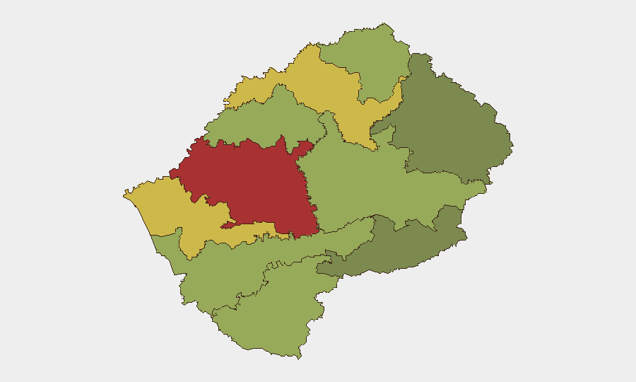
Situation Summary
Lesotho remains stable with no reported armed conflict, civil unrest, or major crime spikes in the last 48 hours. The security environment is characterized by baseline challenges in Maseru District and other urban centers, with current operational disruptions driven by severe weather rather than violence or instability. Government focus is on anticipatory risk reduction through new cybersecurity and disaster-preparedness frameworks rather than crisis response.
Key Developments
- Qacha's Nek Port of Entry (SA–Lesotho border), July 30–August 1, 2026: South Africa's Border Management Authority temporarily suspended cross-border operations due to heavy snowfall, redirecting travellers via Telle Bridge and halting routine movement between the two countries. No security incidents reported; closure is a weather-driven safety measure.
- Maseru (Avani Lesotho Hotel), July 29, 2026: The Ministry of Information formally launched the interim Lesotho National Computer Security Incident Response Team (LesComCSIRT) and the first National Cybersecurity Forum, signalling institutional investment in cyber-incident handling and digital-infrastructure protection.
- Nationwide, July–August 2026: Government launched a disaster preparedness campaign expanding community training, early-warning systems, and multi-agency coordination (disaster management, healthcare, local councils, security personnel) ahead of the severe-weather season.
- Lesotho border region (Eastern Cape/Free State, South Africa), July 31–August 1, 2026: Heavy snow blanketed border areas, creating hazardous road conditions and prompting official advisories against non-essential travel; affects access to and from Lesotho.
- Ramabitsa travel-risk update, July 30, 2026: Composite risk assessment rated the area "moderate risk" (42/100) with no specific new incidents, no active major disaster alerts, and continued application of the US Level-2 travel advisory for Lesotho.
Highest-Risk Areas
Maseru District (risk 78) and Mafeteng District (risk 65) drive the national risk profile, primarily reflecting baseline urban crime, informal-settlement vulnerabilities, and economic-marginalization factors rather than organized violence or conflict. Leribe, Berea, and Mohale's Hoek districts represent the second tier of elevated risk. The southern and eastern districts (Qacha's Nek, Mokhotlong, Quthing) carry lower composite scores, suggesting more dispersed populations and less concentrated criminal activity, though border-proximity and weather-related access challenges remain operational considerations for asset and personnel movement.
How GeoBit Would Assist
Security teams operating in Lesotho should leverage AOI Monitoring & Early Warning capabilities to track Maseru District and other high-risk urban centers for emerging unrest or crime-pattern shifts, with persistent alerting on political, economic, or public-safety triggers. Routing & Network Analysis and GIS & Spatial Analysis are essential for real-time rerouting of personnel or supply chains around weather-disrupted border crossings and hazardous road zones. Intel Sweep (global event feeds, X/Twitter OSINT, multi-language search) provides continuous early warning on cyber threats, given Lesotho's recent national cybersecurity infrastructure investments and the environment's vulnerability to digital incidents during disaster-response operations.
7-Day Outlook
Heavy snowfall is expected to clear within 72 hours, likely allowing Qacha's Nek to resume operations early next week; routine cross-border movement should normalize. Disaster-preparedness activity will continue, and cyber-incident reporting frameworks will become more active, increasing visibility into digital-security incidents that may have previously gone undocumented. No significant escalation in armed conflict, political instability, or organized crime is anticipated over the next seven days absent major external shocks.
Highest-Risk Areas — Ranked
| # | State / Region | Risk |
|---|---|---|
| 1 | Maseru District | 78 |
| 2 | Mafeteng District | 65 |
| 3 | Leribe District | 62 |
| 4 | Berea District | 58 |
| 5 | Mohale's Hoek District | 52 |
| 6 | Butha-Buthe District | 48 |
| 7 | Thaba-Tseka District | 45 |
| 8 | Quthing District | 42 |
| 9 | Mokhotlong District | 38 |
| 10 | Qacha's Nek District | 28 |
Sources
Previous Daily Briefs
A new Lesotho brief is written every day — each with its own risk map and downloadable CSV. Here's the last week; use the calendar to go further back.
📅 Browse every day by calendar →
Highlighted days have a brief. Tap a day for that day's map & analysis, or “csv” for that day's dataset ($5).
Atlas — our AI intelligence desk — emails them this snapshot personally. Nothing else, no list.