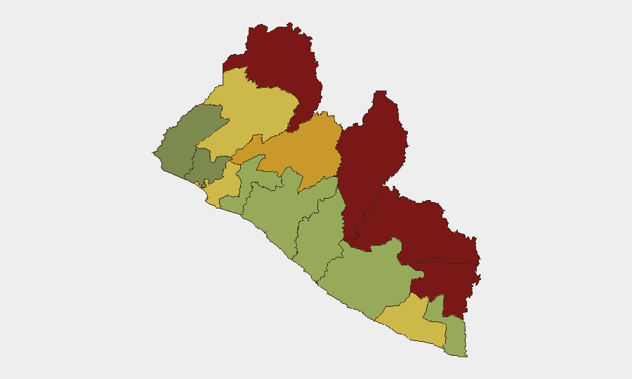
Situation Summary
Liberia remains at composite threat level 14 with no verified security incidents, civil unrest, or conflict clashes reported in the last 48 hours. The security environment is dominated by ongoing government and law-enforcement discourse around recent narcotics enforcement actions and related public statements rather than active ground-level threats. Sub-national risk remains concentrated in the northern border counties (Nimba, Lofa, Grand Gedeh, River Gee), where composite scores range from 83–92, while Monrovia and coastal regions present lower acute risk. The country's trajectory is stable in the immediate term, though institutional capacity challenges persist.
Key Developments
- Government narcotics response — Monrovia, 2026-07-31: Liberian authorities issued public statements rejecting allegations that a diplomatic pouch was involved in a recent cocaine seizure case; no new on-the-ground incident confirmed, but reflects active official messaging and institutional stress-testing.
- Police reform and accountability messaging — Monrovia, 2026-07-31: Liberia National Police leadership announced reform priorities and public accountability initiatives; positioning rather than operational incident, but indicates institutional focus on internal legitimacy.
- No verified unrest cluster — Nationwide, 2026-07-30 to 2026-07-31: Open-source monitoring and corroboration checks found no protests, strikes, riots, clashes, or civil disorder incidents in the last 48 hours.
- No infrastructure disruption confirmed — Nationwide, 2026-07-30 to 2026-07-31: No verified road closures, airport disruptions, power outages, port stoppages, or telecom failures reported in the observation window.
- Narcotics enforcement discourse continues — Monrovia, 2026-07-31: Local media outlets remain active in publishing government and police statements related to prior cocaine interdiction; ongoing narrative management rather than new incident activity.
Highest-Risk Areas
Northern border counties dominate the risk profile: Nimba (92), Lofa (88), Grand Gedeh (85), and River Gee (83) together represent the acutest concentration of composite threat factors. These counties' exposure reflects historical cross-border trafficking patterns, porous security perimeters, and limited state enforcement capacity in remote areas. Bong County (72) and Gbarpolu County (68) extend this northern/northwestern risk corridor. Montserrado County (64), which includes Monrovia, remains moderate in rank but merits focused attention owing to its population density, international business presence, and government/institutional activity; risk here is primarily institutional or crowd-related rather than armed-group driven. Southern and coastal counties (Sinoe, Margibi, Grand Bassa) score lower but remain on active watch.
How GeoBit Would Assist
Security teams should leverage persistent area-of-interest (AOI) monitoring and early-warning alerting on Nimba, Lofa, and Grand Gedeh counties to detect emerging cross-border trafficking, movement, or unrest signals before they escalate. Intel Sweep, X/Twitter and Telegram OSINT, and multi-language search capabilities enable continuous tracking of government statements, police messaging, and institutional instability indicators—critical given Liberia's current focus on narcotics and police reform discourse. Conflict, crime, and regime-stability search functions support rapid corroboration and attribution when new incidents surface, reducing false-positive risk and enabling targeted duty-of-care response for personnel or assets in high-risk counties.
7-Day Outlook
No acute near-term escalation is forecast; the security posture is expected to remain stable over the next week absent major international or domestic political shock. Continued government messaging on narcotics and police reform will likely occupy official bandwidth and media attention. Security teams should maintain routine monitoring of northern counties and track any uptick in cross-border or trafficking-related activity, particularly around port and transit nodes.
Highest-Risk Areas — Ranked
| # | State / Region | Risk |
|---|---|---|
| 1 | Nimba County | 92 |
| 2 | Lofa County | 88 |
| 3 | Grand Gedeh County | 85 |
| 4 | River Gee County | 83 |
| 5 | Bong County | 72 |
| 6 | Gbarpolu County | 68 |
| 7 | Grand Kru County | 65 |
| 8 | Montserrado County | 64 |
| 9 | Rivercess County | 58 |
| 10 | Sinoe County | 55 |
| 11 | Margibi County | 52 |
| 12 | Grand Bassa County | 48 |
Sources
- geobit.ai
- smartnewsliberia.com
- micat.gov.lr
- prensalibre.com
- thenewsnewspaperonline.com
- liberianinvestigator.com
- smartnewsliberia.com
- liberianinvestigator.com
- liberianinvestigator.com
- fpa.news
- liberianinvestigator.com
- openwatch.io
- smartnewsliberia.com
- liberianinvestigator.com
- thenewdawnliberia.com
- thenewsnewspaperonline.com
- emansion.gov.lr
- thenewdawnliberia.com
Previous Daily Briefs
A new Liberia brief is written every day — each with its own risk map and downloadable CSV. Here's the last week; use the calendar to go further back.
📅 Browse every day by calendar →
Highlighted days have a brief. Tap a day for that day's map & analysis, or “csv” for that day's dataset ($5).
Atlas — our AI intelligence desk — emails them this snapshot personally. Nothing else, no list.