Situation Summary
Montenegro remains a low-threat environment (global rank #157, composite threat score 6) with no tracked security incidents in the current 24–48-hour window. The country's security posture is stable, characterized by routine law-enforcement operations and seasonal wildfire risk rather than civil unrest, organized violence, or infrastructure disruption. Northern municipalities bordering Serbia and Albania continue to carry elevated administrative and cross-border risk profiles, though no active incidents are reported in those zones at this time.
Key Developments
- Tuzi (near Podgorica) – 24 August 2026. Four individuals were charged with misdemeanors for displaying an Albanian flag and placing it on a police vehicle. The incident was processed as a public-order offense with no reports of violence or broader unrest.
- Podgorica – 22–24 August 2026. Police arrested two men suspected of selling heroin over an extended period; one suspect attempted to dispose of drugs by throwing a package onto a neighboring roof. The case remains under investigation.
- Podgorica, Mareza neighborhood – 22 August 2026. Law enforcement and prosecutors inspected a residence where more than 50 foreign nationals (predominantly Ukrainian, with Moldovan and Slovak citizens) and significant quantities of digital equipment and cash were recovered. Authorities are investigating possible cyber-crime or fraud-related activity; no specific charges have been filed.
- National – 22 August 2026. Montenegro's Interior Ministry announced a €500,000 reward for information leading to the arrest of Radoje Zvicer, a fugitive wanted in connection with alleged drug trafficking. No new arrests or raids related to this operation have been reported in the last 48 hours.
- Coastal and mountain regions – 12–22 August 2026. A series of wildfires across multiple municipalities (Herceg Novi, Baošići, Danilovgrad, Kolašin, Ulcinj) required deployment of firefighting aircraft and ground teams. Power outages affected nearby settlements in some areas; all reported fires have been brought under control. Wildfire conditions remain the primary operational hazard across the country.
Highest-Risk Areas
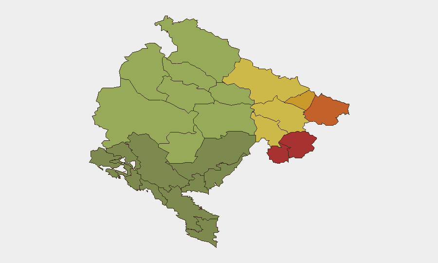
The northern municipalities of Plav (78), Gusinje (76), Rožaje (74), Petnjica (72), and Andrijevica (68) drive the sub-national risk ranking. These areas, situated along the Serbia–Montenegro and Albania–Montenegro borders, carry elevated scores principally due to historical cross-border smuggling networks, informal arms trafficking, and clan-based governance structures rather than active current violence. No acute incidents are reported in these zones in the last 48 hours. Central and southern municipalities show progressively lower risk as proximity to coastal and administrative centers increases.
How GeoBit Would Assist
Security teams operating in Montenegro should employ AOI (Area-of-Interest) Monitoring & Early Warning on northern border municipalities and key transport corridors to detect emerging organized-crime or cross-border activity before it reaches operational scale. Entity & Network Analysis on fugitive tracking (e.g., Radoje Zvicer) and multi-language OSINT fusion of local police reporting and regional feeds will maintain real-time awareness of law-enforcement operations and their proximity to corporate assets. Environmental & Health monitoring combined with GIS spatial analysis enables predictive wildfire-risk assessment for coastal and mountain operational areas.
7-Day Outlook
No significant security escalation is anticipated over the next seven days. Routine law-enforcement operations (organized crime, narcotics, border control) will likely continue at current tempo. Wildfire risk will remain the primary operational hazard, particularly in elevated terrain and coastal zones; suppression capacity appears adequate and sustained.
Highest-Risk Areas — Ranked
| # | State / Region | Risk |
|---|---|---|
| 1 | Plav Municipality | 78 |
| 2 | Gusinje Municipality | 76 |
| 3 | Rožaje Municipality | 74 |
| 4 | Petnjica Municipality | 72 |
| 5 | Andrijevica Municipality | 68 |
| 6 | Bijelo Polje Municipality | 65 |
| 7 | Berane Municipality | 62 |
| 8 | Plužine Municipality | 58 |
| 9 | Pljevlja Municipality | 55 |
| 10 | Šavnik Municipality | 52 |
| 11 | Žabljak Municipality | 50 |
| 12 | Kolašin Municipality | 48 |
Sources
Previous Daily Briefs
A new Montenegro brief is written every day — each with its own risk map and downloadable CSV. Here's the last week; use the calendar to go further back.
- August 22, 2026
- August 20, 2026
- August 18, 2026
- August 15, 2026
- August 13, 2026
- August 11, 2026
- August 9, 2026
📅 Browse every day by calendar →
Highlighted days have a brief. Tap a day for that day's map & analysis, or “csv” for that day's dataset ($5).
Atlas — our AI intelligence desk — emails them this snapshot personally. Nothing else, no list.