Situation Summary
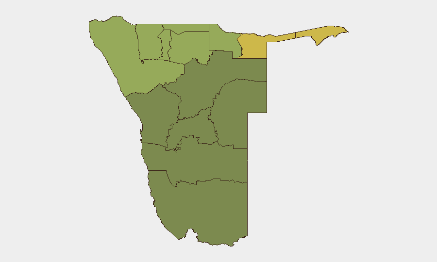
Namibia remains a low-threat environment with a composite risk score of 8 globally. Open-source reporting from the last 24–48 hours contains no verified major security, civil unrest, or infrastructure incidents. Risk is concentrated in the northern border regions (Zambezi, Kavango East/West, Kunene, Oshikoto), where cross-border activity, wildlife poaching, and resource competition historically drive elevated threat levels. The overall security posture remains stable, though regional disparities warrant targeted monitoring.
Key Developments
No credible, time-stamped security, conflict, or civil-unrest incidents meeting the 24–48-hour window have been identified in open web news or verified social media sources. Routine crime and minor incidents occur daily but are either unreported in accessible channels or lack precise publication dates. Two event signals appear in the system—an ALGERIA vs NAMIBIA reference (status: investigate) and a wildfire event (undated)—but neither is currently corroborated by mainstream security reporting. Corporate teams should treat this as a normal operational period absent acute triggers, while maintaining baseline vigilance in high-risk northern zones.
Highest-Risk Areas
Northern border regions dominate the risk ranking. Zambezi Region (risk 68) tops the list, followed by Kavango East (62) and Kavango West (58); these three areas are vulnerable to cross-border smuggling, poaching networks, and resource trafficking due to proximity to Angola and Botswana. Kunene Region (52) faces similar border-transit risks. Oshikoto (48) and Ohangwena (45) also reflect elevated northern risk. By contrast, southern and coastal regions (Hardap, Omaheke, Erongo) score 25–32, reflecting lower population density, fewer crime hotspots, and stable infrastructure. Central business hubs like Windhoek are not listed separately but historically feature petty crime and vehicle theft; asset teams should apply standard urban security protocols there.
How GeoBit Would Assist
AOI Monitoring & Early Warning on Zambezi and Kavango regions would detect emerging cross-border activity, smuggling patterns, or unrest before mainstream reporting. OSINT Fusion (X/Twitter, Telegram, local media) applied to northern constituencies and border towns provides rapid, corroborated signal of localized incidents. GIS & Spatial Analysis combined with Satellite & Imagery would track infrastructure disruption, unauthorized encampments, or resource-extraction hotspots in remote areas. Network & Actor Analysis maps poaching syndicates and smuggling nodes that affect site security and supply-chain risk in frontier zones.
7-Day Outlook
No acute escalation is forecast for the next week. Seasonal wildfire activity may increase in dry savanna zones, potentially affecting transportation and air quality in eastern regions; monitoring national fire-service alerts and regional meteorology is prudent. Northern border tension typically follows quiet rhythms interrupted by sporadic poaching arrests or informal cross-border movement; expect continued low-level baseline activity without major incidents unless external shocks (e.g., Angola instability, regional commodity spikes) materialize. Corporate teams should maintain standard duty-of-care protocols and refresh contingency routes for northern operations.
Highest-Risk Areas — Ranked
| # | State / Region | Risk |
|---|---|---|
| 1 | Zambezi | 68 |
| 2 | Kavango East | 62 |
| 3 | Kavango West | 58 |
| 4 | Kunene Region | 52 |
| 5 | Oshikoto | 48 |
| 6 | Ohangwena | 45 |
| 7 | Omusati | 42 |
| 8 | Oshana | 40 |
| 9 | Otjozondjupa | 35 |
| 10 | Erongo Region | 32 |
| 11 | Hardap | 28 |
| 12 | Omaheke | 25 |
Previous Daily Briefs
A new Namibia brief is written every day — each with its own risk map and downloadable CSV. Here's the last week; use the calendar to go further back.
📅 Browse every day by calendar →
Highlighted days have a brief. Tap a day for that day's map & analysis, or “csv” for that day's dataset ($5).