Situation Summary
Qatar remains at composite threat rank #38 globally (score 53), primarily driven by risk of military strikes stemming from regional Iranian escalation affecting neighboring states. Two critical incidents in the past 48 hours—a major industrial explosion at Ras Laffan LNG facility (13 dead, 66 injured) and direct spillover from regional military operations into Qatari territorial waters (1 fatality)—have elevated immediate operational and maritime safety risk. Concurrent Iranian missile and drone attacks on Bahrain and Kuwait, formally condemned by Qatar's government, signal sustained regional military tension with direct humanitarian and infrastructure consequences for Qatar.
Key Developments
- Ras Laffan Industrial City (northeast Qatar), 27–28 June 2026: An explosion and fire at the liquefied natural gas export facility killed at least 13 workers and injured 66 during operational restart. Authorities classified the incident as a "technical accident," but the timing follows Iranian strikes on the same facility in March, raising questions about infrastructure resilience and restart protocols.
- Qatari territorial waters (offshore), early Sunday 28 June 2026: A Qatari national was killed and an Arab resident injured when their vessel struck shrapnel from military operations in the area. The vessel was located in a search-and-rescue operation; the injured person is in stable condition. This represents direct penetration of Qatar's maritime domain by regional military activity.
- Ministry of Foreign Affairs (Doha), 27–28 June 2026: Qatar formally condemned renewed Iranian missile and drone attacks on Bahrain and Kuwait, characterizing them as violations of sovereignty and international law and warning of escalation risks.
- Dafna district (Doha), 27–28 June 2026: Police arrested 25 individuals following a mass brawl at a restaurant after social-media circulation of incident footage. A localized public-order response; reflects nightlife-area safety concern.
- Regional diplomatic positioning, 27–28 June 2026: Qatar joined Oman, Kuwait, and the UAE in public condemnation of Iranian attacks, signaling active diplomatic engagement and continued Gulf solidarity amid regional military tension.
Highest-Risk Areas
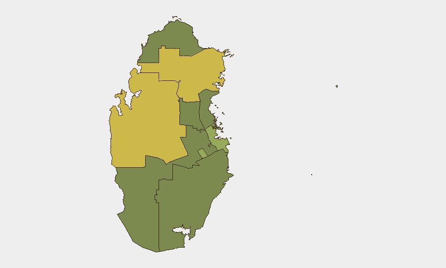
Al Shahaniya (67.3) and Al Khor/Al Thakhira (60.6) carry the highest composite sub-national risk, both driven by proximity to critical energy infrastructure (Ras Laffan LNG complex lies in Al Khor municipality) and strategic coastal exposure to maritime military activity. Doha (54.0) ranks third, reflecting government and diplomatic presence alongside dense population and infrastructure concentration; recent public-order incident in Dafna adds localized concern. Remaining municipalities (37.3–37.3) show moderate, distributed risk, suggesting that infrastructure and maritime/border exposure—not dispersed civil unrest—are the primary sub-national drivers.
How GeoBit Would Assist
Security teams should deploy AOI Monitoring & Early Warning on Ras Laffan and surrounding offshore waters to track operational restart progress and detect unusual military or drone activity near critical infrastructure. Maritime & Aviation tracking combined with Satellite & Imagery analysis would provide persistent visibility of vessel movements and military posture in Qatar's territorial and contiguous waters. Conflict & Military force-structure and weapons-capability tracking, linked to Early Warning & Prediction algorithms, would offer 72–168-hour escalation signals tied to Iranian or proxy activity affecting the Gulf.
7-Day Outlook
Regional military escalation involving Iran and neighboring states is likely to persist through early July, with sustained risk of spillover incidents into Qatari waters and airspace. Industrial recovery at Ras Laffan will remain a national priority and potential focus for further Iranian targeting. Diplomatic positioning will continue to evolve; monitor Qatar's medium-term alignment and any shift in regional mediation posture.
Highest-Risk Areas — Ranked
| # | State / Region | Risk |
|---|---|---|
| 1 | Al Shahaniya | 67.3 |
| 2 | Al Khor and Al Thakhira | 60.6 |
| 3 | Doha | 54 |
| 4 | Ash Shamal | 37.3 |
| 5 | Al Rayyan | 37.3 |
| 6 | Al-Daayen | 37.3 |
| 7 | Umm Salal | 37.3 |
| 8 | Al Wakrah | 37.3 |
Sources
Previous Daily Briefs
A new Qatar brief is written every day — each with its own risk map and downloadable CSV. Here's the last week; use the calendar to go further back.
📅 Browse every day by calendar →
Highlighted days have a brief. Tap a day for that day's map & analysis, or “csv” for that day's dataset ($5).