Situation Summary
Samoa remains in a stable, low-threat security environment with no reported incidents, civil unrest, infrastructure disruptions, or conflict activity in the past 24–48 hours. The composite national threat score of 4 reflects the absence of acute security drivers; the primary ongoing risk factor is a continuing dengue outbreak rather than political or civil instability. No change in trajectory is indicated by current reporting.
Key Developments
- Samoa (national) – 20–21 July 2026: Australian Smartraveller advisory reviewed and reaffirmed with no new security warnings or incident-driven changes, confirming stable conditions for the past 24–48 hours.
- Samoa (national) – 20–21 July 2026: Multi-source threat-assessment platforms report zero credible security incidents, civil disturbances, or infrastructure failures across the country; no imminent civil unrest or political instability forecasted for the coming week.
- Apia and wider Samoa – 19–21 July 2026: Centralized security-risk monitoring reports no acute security events, confirming the stability of the capital and provincial areas.
- Samoa–Australia diplomatic engagement – 20 July 2026: Regional reporting notes routine Samoa–Australia security and climate cooperation, framed as ongoing diplomatic engagement rather than crisis response.
- Samoa health context – 20–21 July 2026: Dengue outbreak remains the primary non-security risk factor; no acute health-system collapse or new outbreak escalation reported in the last 24–48 hours. This is a continuing situation, not newly emergent.
- Seismic activity – recent: A magnitude 5.0 earthquake was recorded 141 km south-southwest of Gataivai; no damage, casualties, or infrastructure impact has been reported. Samoa's exposure to seismic and tsunami hazards remains a baseline risk context.
Highest-Risk Areas
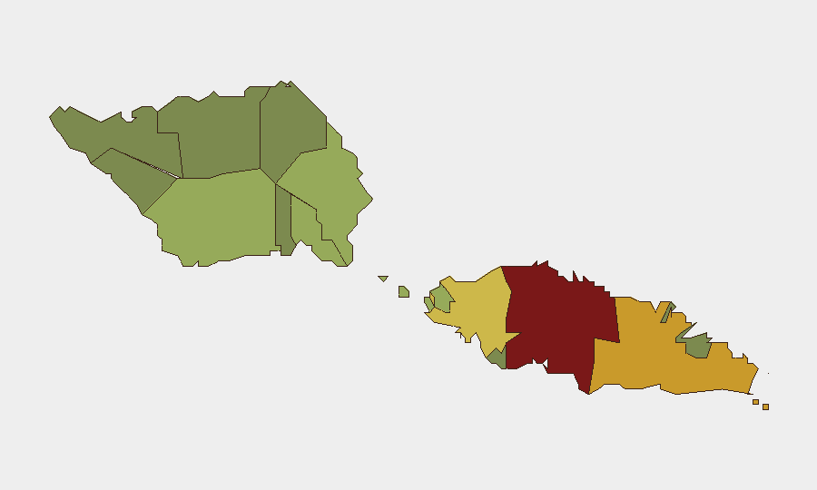
Tuamasaga (risk 85) and Ātua (risk 71) drive the sub-national ranking, followed by Aʻana (risk 62). Tuamasaga, which includes the capital Apia and surrounding urban and industrial zones, likely reflects concentration of population, economic activity, and cross-border movement; Ātua's elevated score may reflect similar demographic and infrastructure density. Lower-risk districts (Vaisigano, Vaʻa-o-Fonoti at 28 and 23 respectively) are less urbanized. None of these designations currently reflect active security incidents; rather, they represent exposure profiles based on structural risk factors.
How GeoBit Would Assist
Security teams with personnel or assets in Samoa would use AOI (Area-of-Interest) Monitoring & Early Warning to maintain continuous watch over Tuamasaga and Ātua for emerging civil unrest, infrastructure disruption, or political instability. OSINT fusion and multi-language search (including local media, social platforms, and Telegram channels) would provide early detection of workforce disputes, supply-chain disruptions, or localized unrest before mainstream reporting. Environmental & Health monitoring would track dengue case trajectories and health-system strain, informing duty-of-care decisions for employee wellbeing.
7-Day Outlook
No acute security deterioration is anticipated in the next seven days based on current reporting and political stability indicators. The dengue outbreak will remain the primary operational risk for organizations managing employee health and absenteeism. Routine seismic monitoring remains warranted given Samoa's Pacific Ring of Fire exposure, though earthquake risk is baseline and not elevated.
Highest-Risk Areas — Ranked
| # | State / Region | Risk |
|---|---|---|
| 1 | Tuamasaga | 85 |
| 2 | Ātua | 71 |
| 3 | Aʻana | 62 |
| 4 | Aiga-i-le-Tai | 55 |
| 5 | Faʻasaleleaga | 48 |
| 6 | Palauli | 42 |
| 7 | Satupaʻitea | 38 |
| 8 | Gagaʻemauga | 35 |
| 9 | Gagaʻifomauga | 32 |
| 10 | Vaisigano | 28 |
| 11 | Vaʻa-o-Fonoti | 23 |
Previous Daily Briefs
A new Samoa brief is written every day — each with its own risk map and downloadable CSV. Here's the last week; use the calendar to go further back.
📅 Browse every day by calendar →
Highlighted days have a brief. Tap a day for that day's map & analysis, or “csv” for that day's dataset ($5).
Atlas — our AI intelligence desk — emails them this snapshot personally. Nothing else, no list.