Situation Summary
Solomon Islands maintains a stable security posture with no verified acute incidents reported in the last 24–48 hours. Baseline risks—urban crime concentration in Honiara, provincial inequality, and historic communal tensions—persist without new triggering events. The country's threat level remains low-to-moderate, with normal port, airport, and transport operations continuing.
Key Developments
- No acute security incidents reported in the last 24–48 hours. Open-source risk monitoring and regional news wires document no verified protests, armed clashes, terrorism activity, major crime spikes, or infrastructure failures across Honiara or provincial capitals as of 31 July 2026.
- Honiara – 29 July 2026: Shiprider Agreement signed. The Solomon Islands Government and United States signed a maritime law enforcement agreement enabling U.S. Coast Guard patrols with local police aboard. This security-sector development enhances fisheries protection and surveillance but represents institutional capacity-building rather than response to an acute threat.
- Gold Ridge Mine area, Guadalcanal – 28–29 July (outside 24–48h window). A landslide at Gold Ridge gold mine resulted in at least one confirmed fatality (Ashley Olo); police recovery operations were ongoing as of 29 July. While this incident occurred just outside the strict 24–48h timeframe, it remains operationally relevant for personnel near the mine site and reflects workplace safety risks in the resource sector.
- Nationwide – stable transport and port operations. Airports (Honiara International, Henderson) and maritime ports continue normal scheduling with no reported disruptions, strikes, or security-related closures.
Highest-Risk Areas
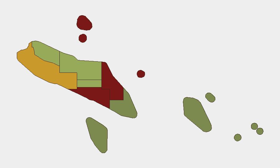
Honiara (risk 92) and Guadalcanal province (88) drive the country's composite risk score, driven by urban crime concentration, gang-related violence, and historical inter-communal tension rooted in the 1998–2003 civil conflict. Malaita (85) and Western Province (72) remain elevated due to ongoing grievance structures and weaker state capacity. These four provinces account for the majority of Solomon Islands' documented crime, civil unrest, and instability risk; Central Province (48) and outlying island groups (Temotu 18, Rennell and Bellona 22) present substantially lower acute threat profiles.
How GeoBit Would Assist
Security teams operating in Solomon Islands should deploy AOI Monitoring & Early Warning (persistent watch on Honiara, port and airport zones, and resource extraction sites) to detect emerging unrest, labor action, or criminal activity in real time. OSINT Fusion & Corroboration (multi-language social media, news wire, and radio signal analysis) enables rapid verification of rumors and incident claims, critical in a low-bandwidth environment where misinformation can accelerate tensions. Routing & Network Analysis supports alternative journey planning for personnel in Honiara and transit corridors, accounting for historical crime and current operational constraints.
7-Day Outlook
No acute escalation is forecast over the next seven days absent external shocks (major natural disaster, political intervention, or labor action). Baseline risks—street crime in Honiara, provincial inequality—will persist. Incoming tropical weather patterns (late July–August cyclone season) pose secondary risks to maritime operations and coastal infrastructure; early warning via environmental monitoring is recommended.
Highest-Risk Areas — Ranked
| # | State / Region | Risk |
|---|---|---|
| 1 | Honiara | 92 |
| 2 | Guadalcanal | 88 |
| 3 | Malaita | 85 |
| 4 | Western | 72 |
| 5 | Choiseul | 58 |
| 6 | Isabel | 52 |
| 7 | Central Province | 48 |
| 8 | Makira-Ulawa | 38 |
| 9 | Rennell and Bellona | 22 |
| 10 | Temotu | 18 |
Sources
Previous Daily Briefs
A new Solomon Islands brief is written every day — each with its own risk map and downloadable CSV. Here's the last week; use the calendar to go further back.
📅 Browse every day by calendar →
Highlighted days have a brief. Tap a day for that day's map & analysis, or “csv” for that day's dataset ($5).
Atlas — our AI intelligence desk — emails them this snapshot personally. Nothing else, no list.