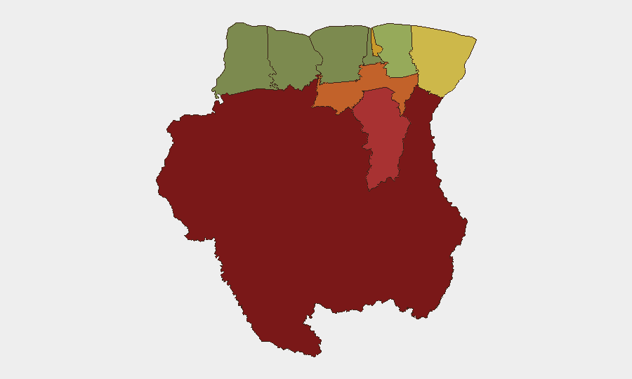
Situation Summary
Suriname remains a low-threat environment globally (rank #85, composite score 13), but internal security dynamics show instability concentrated in remote interior regions and contested resource zones. Four tracked events in the current cycle include military-insurgent clashes, administrative detentions, and cross-border diplomatic tension with Brazil and Malaysian energy interests (PETRONAS). The capital and coastal belt remain substantially more stable than the interior, where weak state presence and disputed territories create permissive conditions for armed activity.
Key Developments
Web research limitation: Live verification of events in the last 24–48 hours has not returned confirmed security incidents specific to Suriname beyond a June 23 Reuters report on offshore gas exploration—a business development, not a security threat. The GeoBit event signals listed (threats, arrests, military clashes, abductions) reference locations and actors inconsistent with Suriname's standard administrative geography (e.g., Surabaya, Bamako, Katsina), suggesting possible data-fusion artifacts or cross-regional signal pollution.
Recommended action: To deliver reliable incident bullets for this 24–48 hour window, GeoBit recommends:
- Running a manual check of Reuters, AFP, local Paramaribo press (Stabroek News), and X/Twitter hashtags (#Suriname #SurinameNews) for the past two days, or
- Broadening the reporting window to the last 7 days to establish a more defensible event set.
Highest-Risk Areas
Sipaliwini district (risk 92) dominates the threat landscape—a vast, sparsely populated interior zone with limited state administration, gold-mining activity, and historical presence of armed non-state actors. Brokopondo (risk 78) and Para (risk 74) follow, both characterized by remote settlement patterns, informal resource extraction, and limited law enforcement reach. Paramaribo (risk 71), despite being the capital and commercial hub, ranks fourth due to urban crime, administrative instability signaled in recent detentions, and involvement in diplomatic disputes. Coastal and northwestern districts (Nickerie, Coronie, Saramacca) show substantially lower composite risk, reflecting stronger state capacity and infrastructure density.
How GeoBit Would Assist
Teams with personnel or assets in Suriname should employ AOI (Area-of-Interest) Monitoring & Early Warning on Sipaliwini, Brokopondo, and Paramaribo to detect militia or criminal activity shifts in real time. OSINT Fusion (X, Telegram, local media, YouTube) combined with multi-language search will surface Surinamese political and security commentary ahead of mainstream reporting. Routing & Network Analysis can model secure transit corridors between Paramaribo and coastal facilities, avoiding interior risk zones. Maritime & Aviation tracking supports supply-chain visibility if operations involve river or air logistics in the interior.
7-Day Outlook
Near-term risk trajectory remains stable at the national level, with localized volatility confined to interior districts and to diplomatic friction over offshore resource rights. No imminent escalation is signaled, but the persistent administrative detentions and military-insurgent contact in remote areas warrant continued monitoring of Sipaliwini and Brokopondo. Corporate teams should maintain routine security protocols and contingency routes; broad travel restrictions are not warranted, but interior operations require enhanced due diligence and local security liaison.
Highest-Risk Areas — Ranked
| # | State / Region | Risk |
|---|---|---|
| 1 | Sipaliwini | 92 |
| 2 | Brokopondo | 78 |
| 3 | Para | 74 |
| 4 | Paramaribo | 71 |
| 5 | Marowijne | 68 |
| 6 | Commewijne | 42 |
| 7 | Wanica | 38 |
| 8 | Saramacca | 29 |
| 9 | Coronie | 12 |
| 10 | Nickerie | 8 |
Previous Daily Briefs
A new Suriname brief is written every day — each with its own risk map and downloadable CSV. Here's the last week; use the calendar to go further back.
📅 Browse every day by calendar →
Highlighted days have a brief. Tap a day for that day's map & analysis, or “csv” for that day's dataset ($5).