Situation Summary
Suriname remains a low–threat environment globally (ranked #172, composite threat score 6) but exhibits significant sub-national variation, with armed robbery, burglary, and narcotics-trafficking activity concentrated in interior and eastern districts. The past week saw police action against drug-trafficking infrastructure and continued street crime in urban areas, though incident frequency remains manageable. The security environment is stable but fragmented by geography: coastal urban zones face property and robbery crime, while remote interior regions present trafficking and organized-crime risks.
Key Developments
- 6 October, Goliath area (Para District): Surinamese Narcotics Brigade discovered an illegal airstrip, fuel containers, and a burned-out twin-engine aircraft with buried engines. No arrests or drug seizures were reported; investigation ongoing.
- 6 October, multiple locations (national): Heavy showers and strong wind gusts caused wind damage and loosened roofing on residential structures across several districts.
- 5 October, location unspecified: Armed robbery incident involving a masked gunman who stole a gold necklace and mobile phones from two brothers after a party; one victim (age 27) was shot in the genital area.
- 2 October, location unspecified: A 36-year-old man was arrested after allegedly breaking into a residence, removing three louvre panes from a bedroom window, and stealing a shoulder bag.
- 1–2 October, International area/apartment location (Paramaribo area): Police Major Crimes Division arrested six alleged fiber-gang members; gunfire was exchanged during the operations.
- September crime reporting (released early October, covering 1–28 September): Police statistics documented 105 burglaries, 28 armed robberies, 27 non-firearm robberies, and seizure of 10 firearms and 13 hunting guns across Paramaribo, Wanica, and other areas.
Highest-Risk Areas
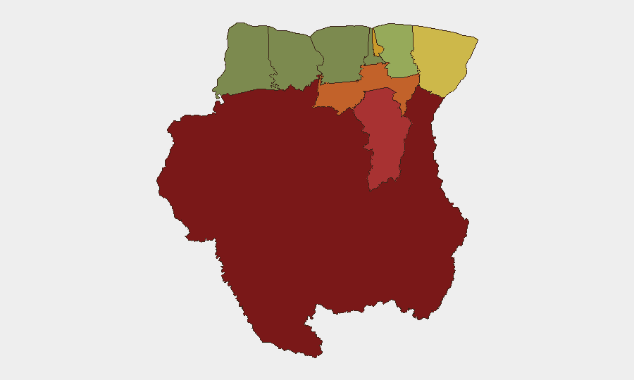
Sipaliwini District (risk score 92) dominates the threat landscape, driven by its remote interior location, limited state presence, and use as a trafficking corridor for narcotics and contraband. Brokopondo (78) and Para (74) follow, with Para's recent airstrip discovery underscoring its role in organized crime. Paramaribo (71), despite being the capital, ranks fourth due to concentrated armed robbery and burglary; Marowijne (68) presents border-adjacent risks. The coastal concentration of commercial activity and population means urban robbery and theft remain frequent, while interior and eastern districts face trafficking and organized-crime infrastructure.
How GeoBit Would Assist
Organizations with personnel or assets in Suriname should deploy AOI Monitoring & Early Warning on high-risk districts (Sipaliwini, Brokopondo, Para) to detect trafficking activity, airstrip construction, or organized-crime movements; couple this with OSINT fusion (social media, local news, police reporting) and Network & Actor Analysis to map criminal organizations and trafficking routes. GIS & Spatial Analysis linked to Maritime & Aviation tracking would provide persistent visibility on narcotics-trafficking hubs and flight corridors, while Routing & Network Analysis can inform secure travel planning for staff in or transiting Paramaribo and Commewijne.
7-Day Outlook
Armed robbery and burglary are expected to persist at current rates in urban areas, particularly Paramaribo and Wanica. Police enforcement actions targeting organized crime and narcotics trafficking will likely continue, with interior districts remaining focal points; the discovery of the Goliath airstrip may prompt heightened law-enforcement attention to Para and Brokopondo. No major escalation in national security is anticipated in the near term.
Highest-Risk Areas — Ranked
| # | State / Region | Risk |
|---|---|---|
| 1 | Sipaliwini | 92 |
| 2 | Brokopondo | 78 |
| 3 | Para | 74 |
| 4 | Paramaribo | 71 |
| 5 | Marowijne | 68 |
| 6 | Commewijne | 42 |
| 7 | Wanica | 38 |
| 8 | Saramacca | 29 |
| 9 | Coronie | 12 |
| 10 | Nickerie | 8 |
Sources
Previous Weekly Briefs
A new Suriname brief is written every Monday, covering the week — each with its own risk map and downloadable CSV. Use the calendar to go further back.
- October 6, 2026
- September 29, 2026
- September 22, 2026
- September 15, 2026
- September 8, 2026
- September 1, 2026
- August 29, 2026
📅 Browse past briefs by calendar →
Highlighted days have a brief. Tap a day for that day's map & analysis, or “csv” for that day's dataset ($5).
Atlas — our AI intelligence desk — emails them this snapshot personally. Nothing else, no list.