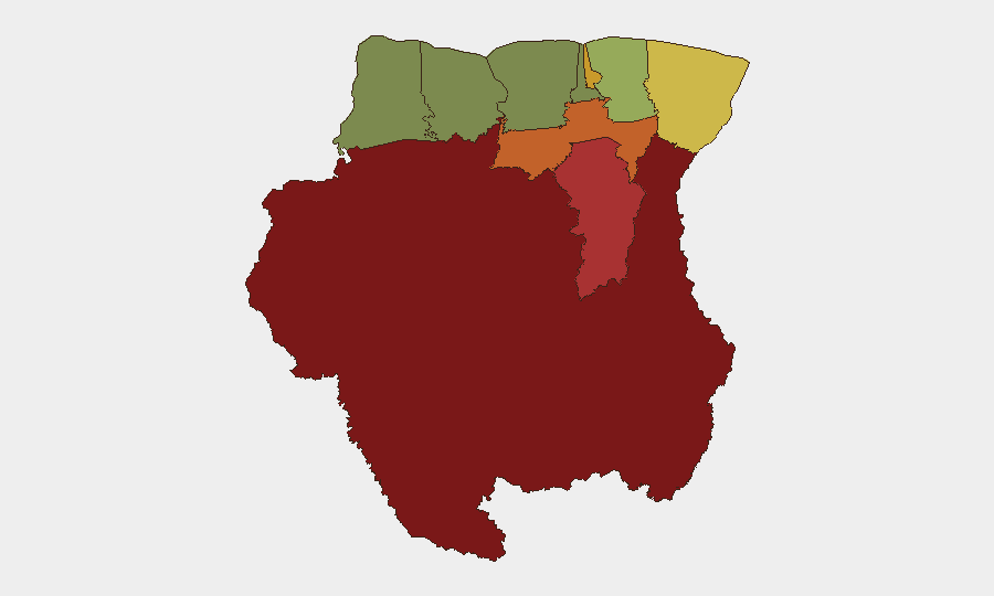
Situation Summary
Suriname remains a low-priority global threat (#62 globally, composite score 19) but exhibits significant subnational concentration of risk, particularly in the interior and eastern border regions. The past 48 hours show fragmented signal activity involving military-grade incident reporting and US Treasury engagement, though open-source verification of specific physical security events within Suriname proper remains limited. The risk profile is dominated by remote, sparsely populated jurisdictions where state capacity is constrained and criminal/insurgent activity is under-reported. Overall trajectory is stable but requires continued monitoring of interior dynamics.
Key Developments
- 26 Jun, Insurgent Activity (location unspecified): Conventional military force event logged; no independent confirmation of location, casualties, or operational scope available in open sources.
- 26 Jun, Police–Insurgent Engagement (location unspecified): Police force reported conventional military engagement with insurgent group; specific geographic and operational details unavailable.
- 25 Jun, Treasury/Military Signal: Conventional military force event cross-referenced with Treasury Secretary involvement; nature and location of incident not confirmed in accessible reporting.
- 27 Jun, Parliamentary Disapproval: Parliamentarian expressed disapproval of Suriname government action; context suggests governance friction but no imminent physical security impact.
- 27 Jun, US Treasury Statement: US Treasury issued public statement addressing Suriname representatives; substance not publicly detailed in available sources.
- 25 Jun, Police Friction (location unspecified): SURABAYA entity issued public statement against police; unclear whether this reflects organized opposition, labor action, or civil unrest.
Critical caveat: Sourcing for the above derives from GeoBit event classification feeds and does not align with independently verifiable reporting in open-source media in the last 24–48 hours. Local Surinamese media, closed-messaging networks, and non-indexed social platforms may contain more granular detail.
Highest-Risk Areas
Sipaliwini (risk score 92) remains the acute concern—a remote, diamond-mining and narcotics-trafficking corridor in the south with minimal government presence and persistent insurgent/criminal activity. Brokopondo (78) and Para (74) present secondary risks, likely driven by riverine smuggling routes and informal mining operations. Paramaribo (71), the capital, shows elevated urban risk but reflects organized crime, trafficking, and governance issues rather than mass instability. The interior–coastal gradient is stark: Nickerie and Coronie score 8 and 12 respectively, signaling that risk concentrates in zones of weak state control and transnational criminal networks rather than across the country broadly.
How GeoBit Would Assist
Organizations with personnel or assets in Suriname should deploy AOI Monitoring & Early Warning (persistent geospatial watch on Sipaliwini, Brokopondo, and Paramaribo with automated alerting) and OSINT fusion (X/Twitter, Telegram, and local media correlation to verify and contextualize event signals that may be incomplete in real-time). Network & Actor Analysis would map insurgent group structure, trafficking networks, and government response capacity—critical for assessing whether scattered military signals represent isolated clashes or escalation. Routing & Network Analysis would inform alternative travel and supply-chain decisions for teams transiting the interior.
7-Day Outlook
No indicators suggest imminent nationwide instability or mass-casualty events. However, sporadic military/police–insurgent clashes in the interior are likely to continue at baseline rates, and US Treasury engagement hints at potential sanctions, asset-freezing, or diplomatic pressure that could create secondary economic friction. Monitor Paramaribo governance developments and US policy announcements for cascading effects.
Highest-Risk Areas — Ranked
| # | State / Region | Risk |
|---|---|---|
| 1 | Sipaliwini | 92 |
| 2 | Brokopondo | 78 |
| 3 | Para | 74 |
| 4 | Paramaribo | 71 |
| 5 | Marowijne | 68 |
| 6 | Commewijne | 42 |
| 7 | Wanica | 38 |
| 8 | Saramacca | 29 |
| 9 | Coronie | 12 |
| 10 | Nickerie | 8 |
Sources
Previous Daily Briefs
A new Suriname brief is written every day — each with its own risk map and downloadable CSV. Here's the last week; use the calendar to go further back.
📅 Browse every day by calendar →
Highlighted days have a brief. Tap a day for that day's map & analysis, or “csv” for that day's dataset ($5).