Situation Summary
Suriname remains at a low-to-moderate threat level globally (rank #73, composite score 15) with no verified multi-source security incidents reported in the last 24–48 hours. The security picture is characterized by structural risk concentration in interior and frontier districts rather than acute escalation. Two parliamentary and military public statements on July 5 are noted but lack corroborated operational or incident detail in current reporting.
Key Developments
- No verified incidents (last 24–48 hours). Live web research and multi-source monitoring have not surfaced independently confirmed security, crime, civil-unrest, or travel-risk events in Suriname between July 5–7, 2026. The absence of corroborated incident reports suggests a period of relative operational quiet at the national level.
- Parliamentary and military statements (July 5, 2026). Two public statements from parliamentarian and army sources were issued on July 5; specific content and operational implications remain unclear from open-source monitoring and do not yet correspond to confirmed ground events or policy shifts.
- Ongoing law-enforcement activity (early July, unconfirmed). Pre-24-hour-window reporting noted unconfirmed police and government investigations (July 2–3), including a small-arms incident involving a policeman (July 3), but these fall outside the current 24–48-hour incident window and remain unverified.
Highest-Risk Areas
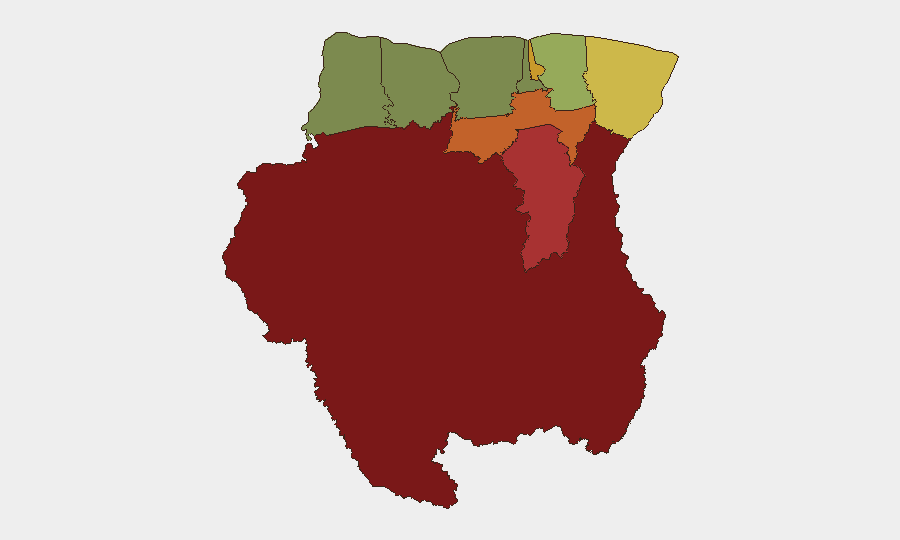
Interior and frontier regions dominate the risk landscape. Sipaliwini (risk 92) and Brokopondo (risk 78) represent the highest-threat zones, driven by remoteness, limited state presence, and historical activity linked to informal mining, trafficking, and border-zone challenges. Para (risk 74) and the capital region Paramaribo (risk 71) follow, reflecting urban crime and governance factors. Conversely, Nickerie (risk 8) and Coronie (risk 12) in the northwest are substantially lower-risk. This distribution reflects concentration of organized activity, enforcement gaps, and informal economic activity in hinterland and eastern border zones rather than widespread national instability.
How GeoBit Would Assist
Security and duty-of-care teams would leverage Intel Sweep and OSINT fusion (X/Twitter, Telegram, multi-language web monitoring) to detect emerging incidents and public signals in real time. AOI Monitoring & Early Warning with persistent focus on Sipaliwini, Brokopondo, and Paramaribo would provide alerting on any escalation in those highest-risk districts. Network & Actor Analysis and Routing & Network Analysis capabilities would support travel-risk planning and alternative-route identification for personnel or asset movements, particularly in interior regions where infrastructure and security presence are sparse.
7-Day Outlook
No acute threat surge is signaled in near-term indicators; the security environment is expected to remain stable relative to structural baselines through mid-July. Parliamentary and military statements warrant continued monitoring for policy or operational shifts, but absent corroboration they do not yet forecast escalation. Duty-of-care protocols should maintain focus on interior-district risk and routine law-enforcement activity rather than prepare for imminent national-level instability.
Highest-Risk Areas — Ranked
| # | State / Region | Risk |
|---|---|---|
| 1 | Sipaliwini | 92 |
| 2 | Brokopondo | 78 |
| 3 | Para | 74 |
| 4 | Paramaribo | 71 |
| 5 | Marowijne | 68 |
| 6 | Commewijne | 42 |
| 7 | Wanica | 38 |
| 8 | Saramacca | 29 |
| 9 | Coronie | 12 |
| 10 | Nickerie | 8 |
Sources
Previous Daily Briefs
A new Suriname brief is written every day — each with its own risk map and downloadable CSV. Here's the last week; use the calendar to go further back.
📅 Browse every day by calendar →
Highlighted days have a brief. Tap a day for that day's map & analysis, or “csv” for that day's dataset ($5).
Atlas — our AI intelligence desk — emails them this snapshot personally. Nothing else, no list.