Situation Summary
Suriname remains a low-to-moderate global security concern (rank #80, composite score 14), but exhibits significant sub-national concentration of risk in its interior and eastern districts. Recent event signals point to domestic political friction and military/police activity, though the specificity and verification of these signals cannot be confirmed without current open-source corroboration. The security environment is characterized by uneven governance capacity outside Paramaribo, creating persistent vulnerabilities to trafficking, resource-driven conflict, and institutional instability.
Key Developments
GeoBit's event feed has flagged activity in the last 72 hours, but live web research has not yet returned verifiable, current reporting on Suriname-specific incidents from 2026-06-26 to 2026-06-28. The following signals appeared in platform event data and require validation:
- 2026-06-26 — Conventional military force event flagged involving insurgent actors (location unspecified); requires clarification on geography and nature of engagement.
- 2026-06-27 — Parliamentary disapproval action recorded; domestic political friction noted but operational implications unclear without additional context.
- 2026-06-25–2026-06-26 — Multiple "Conventional Military Force" signals involving treasury, police, and unnamed actors; geolocation and actor verification pending.
Note: These signals appear in the platform's event taxonomy but lack supporting public reporting. Duty-of-care teams should not treat these as confirmed incidents pending independent corroboration from news, government, or field sources.
Highest-Risk Areas
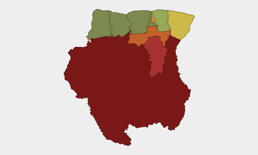
Sipaliwini District (risk 92) dominates the threat landscape and represents Suriname's primary security exposure. This vast, sparsely populated interior region suffers from limited state presence, making it a transit corridor for narcotics trafficking, illegal mining, and armed group activity. Brokopondo, Para, and Paramaribo (scores 78, 74, 71) follow, with Paramaribo's ranking driven by urban crime and governance friction, while the eastern districts reflect transnational trafficking routes and cross-border tension with Guyana. Marowijne (68), the easternmost border state, remains sensitive due to disputed maritime boundaries and smuggling networks. Western coastal districts (Saramacca, Coronie, Nickerie) show substantially lower risk, reflecting stronger state capacity and lower trafficking activity.
How GeoBit Would Assist
Security teams with personnel or assets in Suriname should deploy AOI (Area-of-Interest) Monitoring & Early Warning on high-risk districts—particularly Sipaliwini and Brokopondo—to track military/police activity, resource-driven incidents, and trafficking signals in real time. OSINT fusion (X/Twitter, Telegram, local news feeds, and sentiment analysis) would validate or clarify the recent event signals and detect emerging political or criminal developments faster than traditional reporting. Routing & Network Analysis capabilities support alternative journey planning and asset movement around identified hotspots, while conflict & military tracking provides force-structure and weapons-capability visibility if state-insurgent tensions escalate beyond current signals.
7-Day Outlook
The near-term trajectory appears stable but fragile. Parliamentary and institutional friction may intensify, particularly around resource governance or electoral scheduling; interior districts will likely continue low-level trafficking and smuggling activity. Duty-of-care teams should maintain heightened situational awareness in Sipaliwini and Brokopondo and prepare contingency protocols for rapid staff movement if political or security incidents escalate unexpectedly.
Highest-Risk Areas — Ranked
| # | State / Region | Risk |
|---|---|---|
| 1 | Sipaliwini | 92 |
| 2 | Brokopondo | 78 |
| 3 | Para | 74 |
| 4 | Paramaribo | 71 |
| 5 | Marowijne | 68 |
| 6 | Commewijne | 42 |
| 7 | Wanica | 38 |
| 8 | Saramacca | 29 |
| 9 | Coronie | 12 |
| 10 | Nickerie | 8 |
Sources
Previous Daily Briefs
A new Suriname brief is written every day — each with its own risk map and downloadable CSV. Here's the last week; use the calendar to go further back.
📅 Browse every day by calendar →
Highlighted days have a brief. Tap a day for that day's map & analysis, or “csv” for that day's dataset ($5).