Situation Summary
Tanzania remains a mid-range security environment (global rank #55, composite threat score 33) with fragmented sub-national risk concentrated in the northwest and central zones. The country has not experienced major civil unrest or large-scale criminal incidents in the reported 24–48-hour window; however, wildfire activity across multiple regions has generated humanitarian and infrastructure concerns. Overall political and security stability remains intact, though regional variations are significant and warrant differentiated monitoring by asset location.
Key Developments
Current event signals for Tanzania in the last 24–48 hours are limited to the following confirmed items:
- 2026-06-24 · Wildfire Activity – Multiple wildfires reported across Tanzania (events 1029022, 1028959, 1028919, 1028933); specific locations and impact assessments are under review. Wildfire activity can degrade road access, disrupt supply chains, and create localized displacement.
- 2026-06-24 · Rwanda Border Dynamics – An arrest/detention event flagged in Rwanda on 2026-06-24 may carry implications for cross-border movement and security posture in northern Tanzania (Kagera Region); details on persons or implications for Tanzanian nationals are not yet clear.
- Diplomatic Development (2026-06-23) – UN Security Council action on peacekeeping operations was reported 23 June; this reflects international governance but does not represent an on-the-ground security incident in Tanzania.
Note: Live web research has not yielded specific, time-stamped civil unrest, crime, or conflict incidents within Tanzania for 23–24 June 2026. To obtain granular 24–48-hour incident reporting (location, date, event type), corporate security teams should cross-reference professional crisis-intelligence feeds, Tanzanian government alert channels, and curated local media searches.
Highest-Risk Areas
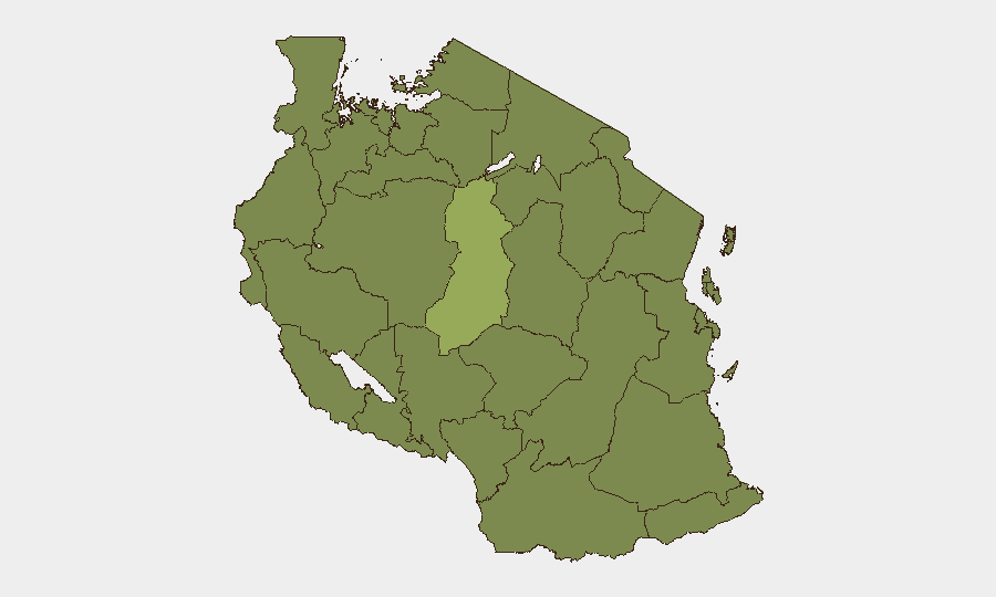
Singida Region stands substantially above all other zones (risk score 51.9), indicating concentrated vulnerability to crime, civil disorder, or humanitarian stress; this region warrants heightened monitoring and restricted movement by personnel without essential presence. A secondary tier of ten regions (Kigoma, Kagera, Mwanza, Geita, Shinyanga, Tabora, Katavi, Rukwa, Songwe, Mara, Simiyu) all score 21.9, reflecting elevated but more uniform background risk likely driven by limited state capacity, border permeability, and resource competition. The northwest corridor—spanning Kigoma, Kagera, and Mwanza—and central Tanzania (Singida) should be treated as priority zones for duty-of-care asset monitoring and contingency planning.
How GeoBit Would Assist
Security and risk teams should deploy GeoBit's AOI Monitoring & Early Warning capability to establish persistent watch on Singida, Kigoma, and Kagera regions, with automated alerting for incident clustering, movement of armed actors, or displacement events. OSINT fusion (X/Twitter, Telegram, YouTube, local media intelligence) across 24–48-hour windows will provide near-real-time ground-truth verification of incident reports and crowd sentiment that wire services may not capture. GIS & Spatial Analysis, combined with Routing & Network Analysis, enables security teams to model alternative movement corridors and identify safe passage windows around active wildfire zones and regional flashpoints.
7-Day Outlook
Wildfire activity is likely to persist through the dry season and may expand to additional regions, complicating logistics and creating secondary humanitarian pressures. No major escalation in political unrest or organized crime is signaled in the near term, though the Singida and northwest regional dynamics merit weekly reassessment. Duty-of-care teams should maintain heightened readiness posture for personnel in high-risk zones and ensure supply-chain redundancy given ongoing environmental disruption.
Highest-Risk Areas — Ranked
| # | State / Region | Risk |
|---|---|---|
| 1 | Singida Region | 51.9 |
| 2 | Kigoma Region | 21.9 |
| 3 | Kagera | 21.9 |
| 4 | Mwanza Region | 21.9 |
| 5 | Geita | 21.9 |
| 6 | Shinyanga Region | 21.9 |
| 7 | Tabora Region | 21.9 |
| 8 | Katavi Region | 21.9 |
| 9 | Rukwa Region | 21.9 |
| 10 | Songwe Region | 21.9 |
| 11 | Mara Region | 21.9 |
| 12 | Simiyu | 21.9 |
Sources
Previous Daily Briefs
A new Tanzania brief is written every day — each with its own risk map and downloadable CSV. Here's the last week; use the calendar to go further back.
📅 Browse every day by calendar →
Highlighted days have a brief. Tap a day for that day's map & analysis, or “csv” for that day's dataset ($5).