Situation Summary
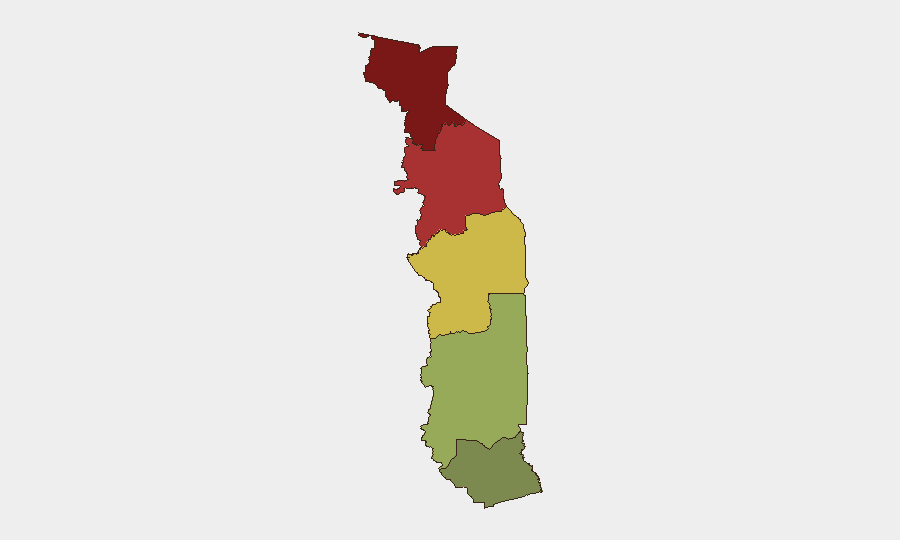
Togo's national composite threat score of 18 reflects a currently stable but fragmented security environment, with risk concentrated in the northern regions and specific urban crime hotspots. The last 48 hours have yielded limited discrete incident-level activity; however, persistent challenges in organized burglary, cross-border weapons trafficking, and northern regional instability remain baseline concerns. The Maritime Region (Lomé) experiences manageable crime pressure, while the Savanes and Kara regions in the north continue to drive the country's overall risk profile. No imminent national-level destabilization is evident, but northern vulnerabilities and transnational crime networks warrant sustained monitoring.
Key Developments
- Grand Lomé, 29 July 2026: National police dismantled a large-scale burglary network operating across Greater Lomé, recovering stolen goods and cash valued at approximately 4.5 million CFA francs. The operation signals renewed law enforcement capacity against organized street crime but underscores persistent targeting of commercial and residential properties in the capital.
- Kétao (Togo) to Malanville (Benin) axis, recent (date unconfirmed): Beninese customs intercepted a shipment of approximately 3,295 sticks of explosives (c. 500 kg) originating from Kétao in Togo's Kara Region and destined for Malanville. The seizure reflects ongoing cross-border weapons trafficking vulnerability and indicates organized criminal or militant supply networks operating along Togo–Benin transit corridors.
- No new event signals detected in the current 24–48-hour window beyond the above two incidents. Broader regional and political risk assessments are available but do not constitute discrete developments within the last two days.
Highest-Risk Areas
Savanes Region (risk score 92) and Kara Region (risk score 78) together account for the majority of Togo's tracked threat profile, driven by persistent border permeability, cross-border militant presence, and organized trafficking networks. The explosives seizure originating in Kétao (Kara Region) exemplifies how northern zones serve as transit and staging points for weapons destined for neighboring Benin and, potentially, further regional actors. Plateaux and Centrale regions show moderate baseline risk (65 and 45, respectively), while Maritime Region (28) reflects Lomé's relative security under active law-enforcement scrutiny, despite organized crime activity. Organizations with personnel or assets in the north should maintain heightened travel and facility protocols.
How GeoBit Would Assist
Security teams managing Togo operations would deploy AOI Monitoring & Early Warning to track developments in Savanes and Kara regions in near-real time, coupled with Border & Disputed-Territory Search and Network & Actor Analysis to map cross-border trafficking nodes and identify evolving criminal or militant actor structures. Intel Sweep and multi-language OSINT (including Telegram and local reporting) would sustain current-event awareness and early signals of trafficking spikes, militant activity, or political friction; GIS & Spatial Analysis would enable alternative routing and facility-risk assessment in high-threat zones.
7-Day Outlook
No imminent national security crisis is anticipated over the next seven days. However, cross-border weapons trafficking and northern regional fragmentation will likely persist, and organized urban crime in Lomé may see episodic surges. Monitoring should prioritize further explosives interdictions, militant activity in border zones, and any police or military escalation in response to northern threats.
Highest-Risk Areas — Ranked
| # | State / Region | Risk |
|---|---|---|
| 1 | Savanes Region | 92 |
| 2 | Kara Region | 78 |
| 3 | Centrale Region | 65 |
| 4 | Plateaux Region | 45 |
| 5 | Maritime Region | 28 |
Sources
Previous Daily Briefs
A new Togo brief is written every day — each with its own risk map and downloadable CSV. Here's the last week; use the calendar to go further back.
📅 Browse every day by calendar →
Highlighted days have a brief. Tap a day for that day's map & analysis, or “csv” for that day's dataset ($5).
Atlas — our AI intelligence desk — emails them this snapshot personally. Nothing else, no list.